

Published: 04 August ‘2025 | The English Chronicle Desk
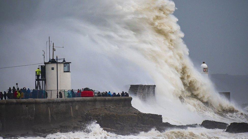
Travel across large swathes of northern Britain has been brought to a standstill as Storm Floris lashes the country with violent winds and relentless rain. With gusts reaching up to 85mph in parts of Scotland, the Met Office has issued multiple weather warnings, including amber alerts for vast regions of Scotland and yellow warnings extending into northern England and Northern Ireland.
Storm Floris, the sixth named storm of the 2024–25 season, intensified overnight and began its onslaught early Monday morning. The amber wind warning in Scotland, in effect from 10am to 10pm, has prompted widespread disruption to rail, road, air, and ferry services, while a yellow wind warning, which took effect at 6am, will remain in place across northern areas of the UK until early Tuesday.

Train operators have urged passengers to reconsider their travel plans, with major lines halting services northward. London North Eastern Railway (LNER) advised against travel beyond Newcastle, while Avanti West Coast issued similar guidance for routes north of Preston, both citing anticipated “significant impact” from the storm. Network Rail confirmed that several key Scottish routes — including Aberdeen, Dundee, Inverness, Fife, Perth, and the West Highland Line — would be closed from noon on Monday. Remaining lines are operating on reduced timetables with longer journey times expected.
Ferry operator CalMac pre-emptively cancelled multiple sailings as the storm surged toward the western coasts of Scotland. Bridges, particularly in exposed areas, are also at risk of closure as conditions deteriorate.
The Met Office has warned of severe wind damage, with exposed coastal areas bearing the brunt of gusts between 70mph and 85mph. Inland locations are not spared either, with speeds ranging from 40mph to 60mph expected to uproot trees, damage power lines, and heighten travel hazards. Forecasters say the strongest winds are likely to strike Scotland Monday afternoon and into the night, particularly along western shores.
Met Office chief meteorologist Matthew Lehnert emphasized the unpredictable nature of the storm’s path and intensity, adding, “Winds will first ease in the west during later Monday but remain very strong overnight in the east. Heavy rainfall may further complicate the situation, contributing to flooding in already vulnerable areas.”
Large public events are also feeling the impact. Edinburgh’s summer festivals — known globally for attracting thousands of visitors — may face disruptions as wind and rain sweep through the city during peak hours.

The storm marks another dramatic turn in a volatile weather season that began last September. Storm Éowyn in January brought widespread flooding and power outages across England, and now Storm Floris is testing the UK’s resilience once again as the country braces for more turbulent conditions in the coming days. Emergency services remain on high alert, while commuters and travellers are advised to monitor updates and avoid non-essential journeys wherever possible.
Related News:
 Storm Floris Sparks Amber Alert in Scotland Amid ‘Danger to Life’ Wind Forecast
 Storm Floris Slams the UK,‘Danger to Life’ Warnings as Ferocious 90mph Winds Cause Chaos Nationwide
 A Delicate Dance of Sunshine and Storms: UK’s Summer Forecast Holds Mixed Fortunes for Holidaymakers
 Fire Contained at Edinburgh’s Arthur’s Seat After Overnight Battle by Firefighters
 England Braces for Prolonged Dry Spell as National Drought Group Urges Urgent Water-Saving Measures
 England Faces “Nationally Significant” Water Shortfall as Fourth Heatwave of 2025 Strikes
 UK Heatwave Continues with Temperatures Soaring, Thunderstorms Forecast Across the Country
 UK Weather: Heat Alerts Extended as Temperatures Set to Reach 30°C This Weekend
 K Braced for 600-Mile Rainstorm with Eight Counties Set to Escape Downpours
 UK Faces One of Its Warmest Summers on Record, Met Office Confirms
 UK Rocked by Two Earthquakes in Three Hours as Tremors Strike Cumbria and Iconic Welsh Landmark
 UK Weather: Rain Expected Above Average This Autumn, but Drought Likely to Persist
 Yellow Weather Warning Issued as UK Braces for Winds Up to 80mph
 Storm Amy set to disrupt travel across UK with winds reaching 95mph
Storm Amy Ravages UK: Fatalities, Widespread Travel Chaos, and Power Outages
Storm Amy Wreaks Havoc Across UK and Ireland, Claims One Life
Storm Amy set to disrupt travel across UK with winds reaching 95mph
Storm Amy Ravages UK: Fatalities, Widespread Travel Chaos, and Power Outages
Storm Amy Wreaks Havoc Across UK and Ireland, Claims One Life
 What is anticyclonic gloom and why is it making the weather?
 UK braces for wet weekend as Met Office issues NI rain warning
 Hermer to face questions on alleged China spy case intervention
 Storm Benjamin Set to Lash UK with Heavy Rain and Strong Winds
 Northern Lights May Illuminate UK Skies Amid Strong Solar Storm
 Northern Lights may illuminate UK skies this week
 New weather warning issued with risk of flooding
Storm Claudia: Torrential Rain to Batter England and Wales
New weather warning issued with risk of flooding
Storm Claudia: Torrential Rain to Batter England and Wales
 Cold Snap Brings Snow Risk as Flood Recovery Continues
 Witnesses Recall Tragedy as Couple Die in Flood
 Commuters warned as yellow snow and ice alert hits Northern Ireland
 UK Energy Bills to Rise Slightly in January
 UK Must Act with Courage and Clarity on Israel-Palestine Conflict, Says Foreign Affairs Committee Report
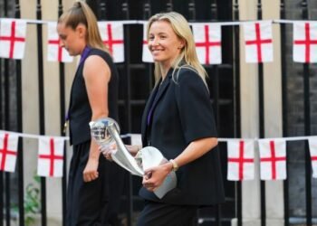 London Set to Honour Euro 2025 Champions as Lionesses Take Victory Parade Through the Capital
 Targeted Attack in Bury Sparks Murder Investigation as Community Awaits Justice
 UK Government Expands ‘Deport Now, Appeal Later’ Policy to 23 Countries
 Manchester Airport Faces Delays After EasyJet Planes’ Wings ‘Clip’ on Runway
 Access to Iconic Cornish Beach Cut Off by National Trust Amid Safety Concerns
 Where Is Prince William and Kate Middleton’s New House? Inside the Historic Lodge Set to Become Their ‘Forever Home’
 Larger Families Could Gain Thousands if Labour Ends Two-Child Benefit Cap
 Drunken Passenger Sexually Assaults Woman on Jet2 Flight from Manchester to Tenerife
 Palestine Action Ban Protesters Plan Tactic to Overwhelm Police at Next London Demonstration
 High Court Rules Against Noel Clarke in Libel Case Against Guardian Publisher
 Desperate Plea to ‘End This Tide of Misery’ as Children Struggle in the English Channel
 Grimsby Stun Manchester United in Dramatic Penalty Shootout
 Rachel Reeves’s Budget Advisor Proposes Sweeping Tax Hikes: What Could Hit Households Next
 Why E-Bikes and E-Scooters Are Making Streets a ‘Nightmare’ for Blind People
 Retail Sales See Uptick Amid Errors and Delays as ONS Faces Scrutiny
 Millions in the UK at Higher Risk of Heart Failure and Stroke Due to Air Pollution, Study Warns
 UK Launches Major Crackdown on Networks Profiting from Online Child Sexual Abuse
 UK Rejoining EU ‘Unlikely in My Lifetime,’ Says Starmer’s Europe Reset Negotiator
 Prime Suspect in Madeleine McCann Case Declines Metropolitan Police Interview Ahead of German Prison Release
 ‘Unite the Kingdom’ Rally Sparks Fears of Far-Right Normalisation Among Minority Britons
 Growing Crisis in UK Schools: One in Three Parents Seek Special Needs Assessments
 Thousands Gather in London to Protest Donald Trump’s Second UK State Visit
 Zarah Sultana Seeks Legal Action After Bitter Clash with Jeremy Corbyn Over Party Membership Funds
 Watchdog, Cornflakes and Courage: Remembering John Stapleton, a Broadcaster Who Did It All
 Mahmood Pledges Reform of Modern Slavery Laws After Court Blocks Deportation Appeal
 UK Government Backs Return of International Rail Travel to Kent Stations
 Arsenal VS Newcastle Hearts with Dramatic Late Turnaround at St James’ Park
 Ed Miliband Urges Labour to Confront Billionaire-Backed Opposition to Net Zero Goals
 Wetherspoon vows to keep prices low amid soaring energy and tax costs
 Digital ID Plans Ignite Debate Over £600m Treasury Tax Boost and Privacy Concerns
 Public Trust in SNP Hits Historic Low Amid NHS Concerns
 Strictly Celebs Starstruck as Cynthia Erivo Shines
 Johnson Suggests Mandelson Linked to China Spy Controversy
 Ministry of Justice fails to file £11bn in spending receipts
 Rachel Reeves signals welfare reform ahead of key budget
 Reform UK candidate fined £19,000 after using AI-generated cases to challenge election
 William Steps Up Over Prince Andrew Palace Response
 Hospice Cuts Raise Alarm Across England Amid Funding Crisis
 Green Party Surges Past Labour in Latest UK Poll
 Children to Learn Local History in Major Curriculum Overhaul
 Prince William Plants Trees with Brazil’s Nature Heroes
 King Charles to Lead Nation in Remembrance Sunday Service
 Starmer Faces Growing Dissent as Labour MPs Weigh Leadership Challenge
 Son Reveals UK Couple in Iran Resort to Hunger Strike for Help
 Former Lion Heskey Warns of Shortage of England Strikers
 ‘Traumatic Wait’: Northern Ireland Women Face Breast Cancer Delays
 Serial Rapist and Former Cop Found Guilty Again
 Most Tories Expect to Support a Farage-Led Government
 Karen Carney Stuns on Blackpool Week, Deserves Strictly Final
 Fibromyalgia Patients Struggle as NHS Fails to Provide Care
 Virgin Media Fined £23.8m Over Telecare Safety Failures


