

Published: 30th July 2025 | The English Chronicle Desk | The English Chronicle Online
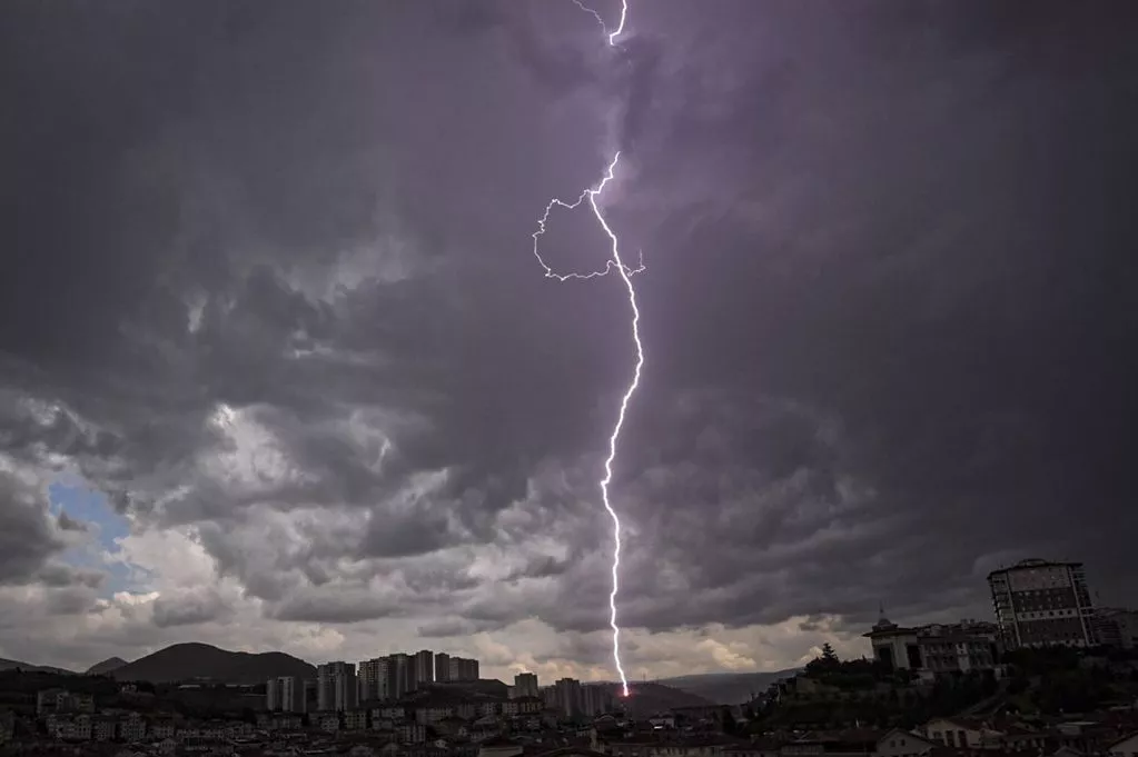
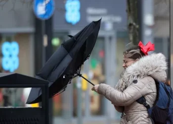
Millions across London and the south of England have been urged to brace for severe weather conditions, as the Met Office issued a yellow thunderstorm warning covering vast swathes of the region. The warning, in place from 10am to 9pm on Thursday, anticipates heavy rain, frequent lightning strikes, and potential flash flooding—all of which could cause widespread disruption to travel and daily life.
According to the Met Office, thunderstorms are expected to develop during the morning hours and intensify through the afternoon. While not all areas will experience the full force of the storm, forecasters are warning that some locations may witness torrential downpours, with rainfall levels ranging between 25 and 35 millimetres within just an hour—and up to 60 millimetres in two hours. Hail and strong, gusty winds are also expected, adding to the already heightened risk of hazardous conditions.
The storms are likely to shift further south and east as the day progresses, with forecasters suggesting they will begin to dissipate by the evening. Nevertheless, residents across affected counties—stretching from London and the South East to the South West of England—are being urged to prepare in advance for possible weather-related chaos.

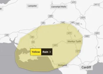
In addition to London, the weather alert encompasses a broad swathe of the country, including urban and rural areas in Suffolk, Kent, Hampshire, Oxfordshire, and Bristol. Towns and cities such as Brighton, Portsmouth, Southampton, and the Isle of Wight are also on alert. The Met Office has advised individuals living in flood-prone zones to consider creating a flood plan and assembling an emergency kit to reduce the risk of property damage or personal danger should flash floods occur.
Households are being advised to secure outdoor objects such as garden furniture, trampolines, tents, and wheelie bins in anticipation of high winds. The threat of power outages has also prompted calls for people to stock essentials like torches, spare batteries, and mobile phone power packs.
Motorists, meanwhile, are being strongly advised to check weather and road conditions before setting off and to avoid unnecessary travel during periods of peak storm activity. Public transport users should also verify timetables and allow for unexpected delays or cancellations.
In its broader UK forecast, the Met Office predicted more settled conditions later in the week. Friday is expected to bring scattered showers, particularly in the East, while Saturday looks to be largely dry with warm sunny intervals. However, Sunday may see the arrival of more locally heavy rainfall, although temperatures throughout the weekend are forecast to remain near seasonal averages.

The yellow warning covers a long list of administrative areas and local authorities across southern and central England. Among the locations under alert are Central Bedfordshire, Hertfordshire, Essex, Thurrock, Southend-on-Sea, Luton, and Suffolk in the East; Greater London, Surrey, Kent, East Sussex, West Sussex, and Hampshire in the South East; and further west, counties such as Bristol, Somerset, Gloucestershire, Dorset, and Wiltshire.
The scale and reach of this weather warning highlight the severity of the developing meteorological situation and the importance of preparedness. While some areas may escape the brunt of the storms, the risk of sudden downpours, flooding, and transport disruption remains high. The Met Office continues to monitor the situation closely and is expected to issue further updates as the conditions evolve.
As summer storms remind residents that severe weather is not confined to winter months, public attention turns once more to the resilience of infrastructure and the readiness of communities to cope with natural events that can quickly spiral beyond expectation.
Related News:
 Severe Thunderstorms Lash England and Scotland: Met Office Issues Amber and Yellow Warnings Amid Flooding Risks
 Scorching Skies: England Gripped by Record-Breaking Heatwave Amid National Alerts
 Tsunami Panic Grips Pacific Rim After One of Century’s Strongest Quakes Shakes Russia, Sparks Global Evacuations
 Massive Earthquake Off Russia’s Kamchatka Coast Sparks Widespread Tsunami Alerts and Volcanic Eruption
 Storm Floris Sparks Amber Alert in Scotland Amid ‘Danger to Life’ Wind Forecast
 Storm Floris Batters Northern UK With Ferocious Winds and Disrupts Travel Nationwide
 Storm Floris Slams the UK,‘Danger to Life’ Warnings as Ferocious 90mph Winds Cause Chaos Nationwide
 A Delicate Dance of Sunshine and Storms: UK’s Summer Forecast Holds Mixed Fortunes for Holidaymakers
 UK Weather Update: Hottest Day of Heatwave Forecast with Chance of Temperatures Reaching 35°C
 Fire Contained at Edinburgh’s Arthur’s Seat After Overnight Battle by Firefighters
 England Braces for Prolonged Dry Spell as National Drought Group Urges Urgent Water-Saving Measures
 England Faces “Nationally Significant” Water Shortfall as Fourth Heatwave of 2025 Strikes
 Europe Swelters Under Historic Heatwave as Wildfires Rage Across the Continent
 UK Heatwave Continues with Temperatures Soaring, Thunderstorms Forecast Across the Country
UK Weather: Heat Alerts Extended as Temperatures Set to Reach 30°C This Weekend
UK Heatwave Continues with Temperatures Soaring, Thunderstorms Forecast Across the Country
UK Weather: Heat Alerts Extended as Temperatures Set to Reach 30°C This Weekend
 Search Underway for Missing After Pakistan Flash Floods Kill Over 330
 K Braced for 600-Mile Rainstorm with Eight Counties Set to Escape Downpours
 UK Faces One of Its Warmest Summers on Record, Met Office Confirms
 UK Rocked by Two Earthquakes in Three Hours as Tremors Strike Cumbria and Iconic Welsh Landmark
 UK Weather Forecast: Rain and Storms to Break Summer Heatwave Across Britain
 Met Office Issues Urgent Rain Warning for Southeast England, Advises Residents to Prepare Emergency Kit
 Massive 641-Mile Storm Set to Batter UK with 15 Hours of Rain and Strong Winds
 UK Weather: Rain Expected Above Average This Autumn, but Drought Likely to Persist
 Met Office Issues Urgent Weather Warning as 80mph Winds Threaten Millions Across the UK
 Yellow Weather Warning Issued as UK Braces for Winds Up to 80mph
 Typhoon Ragasa Batters Taiwan, Hong Kong and China
 Storm Amy set to disrupt travel across UK with winds reaching 95mph
Storm Amy Ravages UK: Fatalities, Widespread Travel Chaos, and Power Outages
Storm Amy Wreaks Havoc Across UK and Ireland, Claims One Life
Storm Amy set to disrupt travel across UK with winds reaching 95mph
Storm Amy Ravages UK: Fatalities, Widespread Travel Chaos, and Power Outages
Storm Amy Wreaks Havoc Across UK and Ireland, Claims One Life
 Everest Blizzard Chaos: Hundreds Stranded as Rescuers Battle Deadly Snowstorm
 What is anticyclonic gloom and why is it making the weather?
 UK braces for wet weekend as Met Office issues NI rain warning
 Hermer to face questions on alleged China spy case intervention
 Storm Benjamin Set to Lash UK with Heavy Rain and Strong Winds
 Biggest Supermoon of the Year to Dazzle Sky on Wednesday
 Delhi Tightens Curbs as Citizens Protest Over Toxic Air
 Northern Lights May Illuminate UK Skies Amid Strong Solar Storm
 UK Faces Arctic Blast as Polar Vortex Disruption Brings Heavy Snow
 Northern Lights may illuminate UK skies this week
 New weather warning issued with risk of flooding
Storm Claudia: Torrential Rain to Batter England and Wales
New weather warning issued with risk of flooding
Storm Claudia: Torrential Rain to Batter England and Wales
 Cold Snap Brings Snow Risk as Flood Recovery Continues
 Snow and Ice Warnings Affect Scotland and Northern England
 Thousands at Risk in Gaza Amid Winter Flooding
 Witnesses Recall Tragedy as Couple Die in Flood
 Commuters warned as yellow snow and ice alert hits Northern Ireland
 Arctic Blast Hits UK as Snow and Ice Warnings Trigger Travel Disruption
 West Councils Falling Behind on Climate Goals
 Africa Demands Climate Justice Linked to Colonial Past
 Snow and Ice Cause Travel Chaos in North Yorkshire
 Turkey to Host COP31 After Breakthrough Deal with Australia
 UK Energy Bills to Rise Slightly in January
 Trump EPA Moves to Roll Back Soot Pollution Limits
 Delhi’s Toxic Air Crisis Leaves Children Sick and Vulnerable
 Australia Launches Major Environmental Law Reforms
 Sri Lanka Floods Leave 56 Dead, Dozens Missing
 Families wait in agony for missing after Hong Kong tower blaze
 Rare shark attack kills woman, injures man at remote NSW beach
 Delhi’s Toxic Air Drives Spike in Respiratory Illnesses
 ‘Extinct’ Antelope Returns to Sahara, Bringing Hope


