

Published: 09 February 2026. The English Chronicle Desk. The English Chronicle Online.
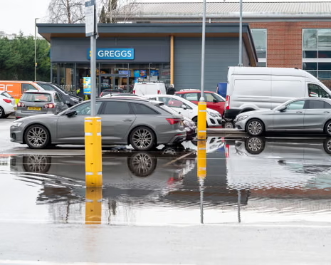
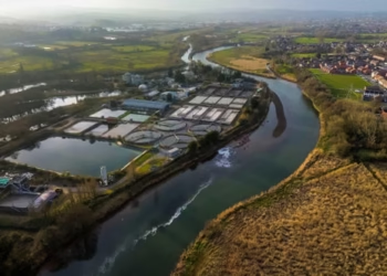
Communities across England and Wales are preparing for further heavy rainfall as UK flood alerts remain high. More than two hundred UK flood alerts are currently active after days of unsettled weather and repeated downpours. Verified reports from national weather services and emergency agencies confirm that ground conditions remain saturated in many areas. This raises the likelihood of fresh flooding as new rain bands approach from the southwest. Authorities are urging residents to stay informed and take precautions as conditions develop through the coming hours.
The Met Office has issued a fresh yellow weather warning for rain covering large sections of southern Wales and southern England. The warning period runs from midday through to midnight on Monday, with forecasters expecting steady rainfall across exposed coastal and inland regions. Meteorologists state that rainfall totals between ten and fifteen millimetres are likely across a wide area. Some elevated and windward locations could see totals reaching thirty millimetres under persistent rain bands and gusty winds.
Weather experts explain that the current system is being driven by moist air moving in from the south and southeast. This flow is pushing rain onto coastlines and higher ground that have already absorbed repeated storms. Because soils are already waterlogged, even moderate rainfall could quickly turn into runoff and surface flooding. That risk has kept UK flood alerts at elevated levels across multiple regions since the weekend.

Several of the affected zones are still recovering from earlier flooding linked to the recent storm system that struck parts of Britain. Local councils and response teams continue cleanup and inspection work in previously flooded neighbourhoods. Rivers remain swollen in some catchments, and drainage networks are under pressure after continuous wet weather. Emergency planners say that additional rainfall falling onto saturated catchments increases the chance of rapid water level rises.
The Environment Agency has issued dozens of formal flood warnings across England where flooding is considered expected rather than possible. Alongside these warnings, hundreds of advisory notices remain in place where flooding threats could develop quickly. Natural Resources Wales has also maintained multiple alerts covering vulnerable river basins and low-lying communities. These combined measures show how seriously authorities are treating the present UK flood alerts situation.
Officials warn that homes, small businesses, and transport links could be affected if rainfall intensifies during peak periods. Road flooding and standing water are considered likely on secondary routes and known low spots. Drivers are being advised to allow extra travel time and avoid water-covered roads where depth is uncertain. Rail operators are also monitoring track conditions in historically vulnerable corridors across the warning area.
Despite the unsettled pattern, temperatures across parts of central and eastern England may reach double figures. Forecasters say milder air is being drawn northward ahead of the rain system, making daytime conditions feel less wintry. However, the mild temperatures also support continued snowmelt in higher terrain, which can add extra water into river systems. That added runoff is another factor behind the continued UK flood alerts across several catchments.
Meteorologists note that wind direction will play an important role in how rainfall distributes across the landscape. South-easterly winds are expected to strengthen through the afternoon, especially near southwestern coasts and headlands. These winds can push moisture further inland and enhance rainfall on exposed slopes. When combined with saturated ground, that pattern increases the probability of localised flooding by evening.
Transport analysts are watching the Monday evening rush period closely due to projected rainfall timing. Surface water accumulation is considered likely in urban areas with limited drainage capacity. Poor visibility and spray could also create hazardous driving conditions on major roads and motorways. Commuters are being encouraged to check live travel updates before starting their journeys.
Recent official estimates suggest that at least several hundred properties have already experienced flooding during the latest wet spell. At the same time, many thousands more have been protected due to permanent and temporary flood defences. Barriers, storage basins, and improved river channels have reduced the overall damage footprint in defended areas. Even so, emergency managers stress that defences reduce risk but cannot eliminate it entirely.
Flood duty managers monitoring the situation say groundwater flooding remains a concern in parts of southern England. Counties with chalk geology are especially vulnerable because groundwater levels respond slowly but persistently after prolonged rain. In these places, flooding can continue for days even after rainfall eases. That delayed effect is another reason UK flood alerts may stay active beyond the immediate weather warning window.
Field teams have been deployed across multiple regions to inspect flood barriers and clear debris from channels. Crews are removing blockages from culverts and small rivers to maintain steady water flow where possible. Monitoring equipment is also being checked and recalibrated to ensure accurate river level readings. These operational steps help authorities respond quickly if thresholds are exceeded.
Community response groups are again playing an important role in supporting vulnerable residents. Volunteers are helping distribute sandbags, share verified updates, and check on isolated neighbours. Local resilience forums say early information sharing reduces panic and improves practical decision making. They encourage the public to rely on official sources rather than unverified social media claims.
Insurance advisers are also reminding property owners to document any damage as soon as it is safe. Photographs and written records can help speed up later claims and assessments. People in flood-prone zones are being advised to move valuables upstairs and prepare basic emergency kits. Simple steps taken early often reduce losses when water levels rise unexpectedly.
Climate researchers observing recent seasons note that rainfall patterns are becoming more variable and intense. Short periods of very heavy rain are appearing more often within otherwise mild winters. This shift places greater stress on drainage systems designed for older weather averages. Long-term infrastructure planning is increasingly factoring in repeated UK flood alerts scenarios.
Water management experts argue that natural floodplain restoration can reduce downstream risk over time. Allowing certain upstream areas to store excess water can lower peak river levels further along. Projects involving wetland recovery and river re-meandering are already underway in several regions. These approaches aim to balance environmental benefits with practical flood reduction.

For now, attention remains focused on the approaching rain band and its immediate impacts. Forecast models suggest the heaviest bursts will be scattered rather than continuous across the warning area. Even so, scattered heavy cells can still produce disruptive local flooding within a short period. That uncertainty keeps response agencies on a heightened readiness footing.
Residents in affected areas are being urged to check river level dashboards and local authority guidance regularly. Signing up for automated warning messages can provide early notice of changing conditions. Officials stress that personal safety should always come before property protection during flood incidents. Entering floodwater on foot or by vehicle remains one of the most common causes of harm.
As the latest system moves through, updated assessments will determine whether warnings can be reduced or must expand. Weather and river models will be reviewed continuously throughout the day and evening. Until then, the message from authorities remains cautious and consistent across all regions. Continued vigilance is advised while UK flood alerts remain widely in force.
Related News:
 Peterborough Mosques Tighten Security After Attack
 Reeves Faces Setback as Labour May Miss Homes Target
 Hospice Cuts Raise Alarm Across England Amid Funding Crisis
 Kate Winslet to Narrate Film Highlighting King’s Environmental Mission
 Green Party Surges Past Labour in Latest UK Poll
 Trump’s UK Ambassador Urges North Sea Drilling to Strengthen US Ties
 Children to Learn Local History in Major Curriculum Overhaul
 Granit Xhaka Rescue Earns Everton Draw at Sunderland
 French Taxi Driver Cleared in David Lammy Theft Case After Fare Dispute
 UK Bans Fake Numbers: Scammers Lose Their Trick
 Prince William Plants Trees with Brazil’s Nature Heroes
 M&S Profits More Than Halve After Cyber-Attack
 Just Stop Oil Protesters Convicted Amid Climate Defence Row
 Kent village told to remove flags before Christmas lights go up
 Patients to Test Health at Home to Ease NHS Winter Pressure
 King Charles to Lead Nation in Remembrance Sunday Service
 How to get help when a child goes missing – call 999 urgently
 Palace May Restore Hyphen to Andrew Mountbatten-Windsor’s Name
 Millionaires group urge Reeves to introduce wealth tax to ‘lift kids out of poverty’
 Starmer Faces Growing Dissent as Labour MPs Weigh Leadership Challenge
 Shouting Works Best to Deter Gulls, UK Study Finds
 Reeves rejects £1bn plea for NHS redundancy payouts
 Northern Lights may illuminate UK skies this week
 PM Condemns Leaks, Vows Loyalty to Ministers and Stability
 Son Reveals UK Couple in Iran Resort to Hunger Strike for Help
 Major Rent Reform Ends No-Fault Evictions in England
 Peers Flood Assisted Dying Bill with 942 Amendments
 Former Lion Heskey Warns of Shortage of England Strikers
 Criminal Gangs Pose as Truckers to Hijack UK Supply Chains
 Stroke Patient Mistaken for Drunk, Care Delayed
 Mother Watches in Horror as Teen Daughter Dies on Tracks
 Van Dwellers Face Eviction After Park Misuse Sparks Outcry
 ‘Traumatic Wait’: Northern Ireland Women Face Breast Cancer Delays
 Serial Rapist and Former Cop Found Guilty Again
 Royal Navy Shadows Russian Warships Entering the Channel
 Inside the Helpline Protecting Missing Children in the UK
 Most Tories Expect to Support a Farage-Led Government
 Boots Showstopper Beauty Bundle Outshines Many Advent Calendars This Holiday Season
 Bill Murray Terrified Wes Anderson but Became His Closest Collaborator
 Labour’s ‘blinkered’ drive to build risks pushing wildlife to point of no return, nature experts warn
 PlayStation PS5 Deals Hit Lowest Prices Ahead of Black Friday
 Karen Carney Stuns on Blackpool Week, Deserves Strictly Final
 Five-Year-Old Dies After Rare Tonsil Surgery Complication
 Fibromyalgia Patients Struggle as NHS Fails to Provide Care
 Starmer Says Labour’s Economic Plan Needs Years to Deliver
 Virgin Media Fined £23.8m Over Telecare Safety Failures
 More Patients Now Contacting GPs Online, Data Shows
 UK unemployment rises to four-year high of 5.1% before budget
 Culture secretary to review Telegraph takeover by Daily Mail owner
 Wiltshire Police Use Lasso to Catch Rampaging Village Goat
 Prince George Helps Father at London Homelessness Charity
 Children to Receive Home Vaccines as England Acts
 Cambridge College Faces Backlash Over Private School Recruitment
 NHS Violence Crisis: Staff Face Daily Assaults
 Celebrity Campaign Highlights SMA Screening Failures
 Bereaved Fathers Gain New Paternity Leave Rights in UK
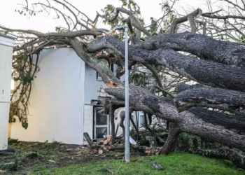 Storm Goretti leaves Cornwall homes without power
 New Documentary Examines Teen’s Zombie Knife Murder
 Woman Jailed for Life After Killing E-Bike Rider in Tragic Mistaken Identity Case
 Right Must Unite After Jenrick Defection, Urges Rees-Mogg
 UK Ministers Drop Foreign Student Targets for Global Education Push
MPs warn AI financial risks threaten UK stability
UK Ministers Drop Foreign Student Targets for Global Education Push
MPs warn AI financial risks threaten UK stability
 No Gas Boiler Ban as UK Warm Homes Plan Backs Heat Pumps
 UK Glaucoma Rise Signals Looming Eye Health Crisis by 2060
 Shinzo Abe’s killer receives life sentence in Japan
 Police response times face strict new national limits
 Edinburgh, Glasgow Lead UK Nightlife Hotspots, Uber Data
 Labour policing overhaul sparks fears over growing central control
 Devon hosts first high-density hydro power system
 Pornhub blocks new UK users over age checks dispute
 Reform candidate sparks British identity row in byelection
 Starmer warns of toxic division politics in Reform challenge
 Households in England Face Rising Water Bills in April
 UK New Car Discounts Near £6,000 as Prices Are Slashed
 Pneumonia Surge Pushes England Emergency Cases Higher
 Harvey Willgoose School Stabbing Red Flags Missed
 Email Appears to Confirm Photo of Andrew With Virginia Giuffre Is Real
 Wigan Dump Crisis Sparks Health and Safety Alarm
 Palantir contracts face UK halt calls over transparency
 Teen Girl Chased in Broad Daylight in Ipswich


