


Published: 27 March 2026. The English Chronicle Desk. The English Chronicle Online.
The natural world has displayed its immense power this week through a series of dramatic events. From the frozen peaks of the Alps to the sun-scorched coasts of Australia, weather patterns shifted. A significant weather tracker monitored the rapid progression of these systems across two very different hemispheres yesterday. The contrast between the biting cold in Europe and the tropical fury in the Pacific is stark. Scientists and meteorologists are watching these developments with increasing concern as the month of March concludes. These events remind us of the fragile balance that governs our global climate and daily lives.
In Southern Europe, a powerful area of low pressure has dictated the rhythm of the week. This system originally brought a sharp chill to the United Kingdom before sliding further southwards recently. As it moved, it dragged a cold front across western and central parts of the continent. The transition was swift, turning mild spring afternoons into scenes reminiscent of the deepest midwinter months. Rain soon turned to heavy snow across the majestic peaks of the high Alpine regions. By Wednesday, the mountains were white, and the air carried a distinct and freezing northern bite.
The Swiss Alps have seen particularly heavy accumulations of snow over the last forty-eight hours. Forecasts predicted between sixty and one hundred centimetres of fresh powder above one thousand metres today. Lower elevations were not spared either, with significant snowfall recorded as low as six hundred metres. This sudden return of winter has delighted some skiers but created hazardous conditions on mountain roads. Local authorities have issued several warnings to travelers and residents living in these high-altitude areas. The sheer volume of snow in such a short period has surprised many seasoned local observers.
Further east, the Adriatic Sea became the central stage for this turbulent and freezing weather system. The low-pressure centre established itself firmly over the water on Thursday, bringing intense atmospheric instability. Sharp, thundery showers lashed the coastal regions, accompanied by sleet and heavy rain in lower areas. In the mountains surrounding the sea, the rain quickly transitioned into thick and heavy hill snow. Croatia has emerged as one of the most adversely affected nations during this recent cold snap. The Gospić region, in particular, faced a forecast of up to fifty centimetres of white snow.
Strong north-easterly winds have exacerbated the situation by creating dangerous blizzard conditions and deep snowdrifts. These winds are not merely gusts but a specific and powerful regional phenomenon known as bora. The bora is a cold, dense katabatic wind that pours down from the coastal mountain ranges. At Rijeka international airport, sensors recorded a powerful gust reaching nearly seventy miles per hour recently. National weather agencies in Croatia and Slovenia have maintained high alert levels for their coastal populations. Peak gusts could potentially reach one hundred miles per hour before the current weather system finally.
While conditions are expected to ease slightly by Friday evening, the danger has not fully passed. Residual ice and drifting snow continue to pose a threat to transport and essential local infrastructure. The influence of the bora winds remains a primary concern for safety officials in the region. Emergency services have been working around the clock to clear vital routes and assist stranded motorists. It is a stark reminder of how quickly seasonal transitions can be interrupted by polar air. This European cold wave has certainly left a lasting impression on the start of the spring.
On the opposite side of the globe, a different kind of meteorological drama has been unfolding. Northern Australia has been grappling with the immense power of a storm named Cyclone Narelle lately. This tropical system formed in the south-west Pacific Ocean back on the fifteenth day of March. It intensified rapidly, reaching the formidable status of a category four storm on the Saffir-Simpson scale. With gusts exceeding one hundred and sixty-five miles per hour, it posed a massive coastal threat. Queensland was the first to feel the outer bands of this swirling and dangerous vortex.
Cyclone Narelle has performed a rare and remarkable feat of navigation across the vast Australian continent. After making its initial landfall, the storm moved steadily along the entire northern coast of Australia. Most cyclones dissipate quickly over land, but Narelle maintained its core structure with surprising seasonal resilience. It eventually re-emerged over the warm and energizing waters of the Indian Ocean this past Tuesday. This path mimics the legendary journey of Cyclone Steve, which occurred over twenty-five years ago. Such a long-lasting trans-continental journey is an exceptionally rare event in modern Australian history.
By Thursday, the storm regained its category four strength as it turned sharply towards the south. The North West Cape of Australia sat directly in the path of this re-energized tropical beast. Residents in Western Australia have been bracing for the final leg of this long storm tour. The system is expected to move inland near Perth, the capital of the Western Territory. While it may weaken slightly over land, the threat of flooding and wind remains high. Local communities have spent the week securing property and preparing for the arrival of the rain.
The scale of these two weather events highlights the global nature of our complex climate system. While Europe deals with unseasonal snow, Australia confronts the raw power of a persistent tropical cyclone. These phenomena are being documented closely by every major international and regional weather tracker today. Such data is vital for understanding how these systems evolve and impact various human populations. Both the cold in the north and the heat in the south provide valuable scientific insights. They show us that the atmosphere is a single, interconnected web of energy and moisture.
The social and economic impacts of these weather systems are often felt long after they pass. In Europe, the agricultural sector faces challenges from the sudden and deep frost in late March. Early blossoms and emerging crops can be easily destroyed by a sudden drop in evening temperatures. In Australia, the infrastructure of the north-west must withstand the battering of heavy rain and wind. Mining operations and shipping lanes are often disrupted, leading to significant delays in global trade. Resilience and preparation are the only defenses against such overwhelming and unpredictable natural forces.
As we look ahead, the importance of accurate forecasting and international cooperation has never been clearer. Sharing data across borders allows nations to prepare for incoming threats with much greater precision. The use of a reliable weather tracker helps save lives and protect valuable property every year. As the climate continues to change, these extreme events may become more frequent or more intense. Staying informed and adaptable is the best way for society to navigate an increasingly turbulent world. For now, the world watches as these two powerful systems begin their slow final decay.
Related News:
 ‘Extinct’ Antelope Returns to Sahara, Bringing Hope
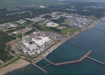 Japan Prepares for Kashiwazaki Restart After Fukushima Legacy
 Half the World’s Largest Cities Face Rising Water Stress
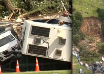 The Sound of Mayhem’: Terror and Loss at Mount Maunganui
 Reindeer Deaths Rise as Finnish Herders Blame Border Wolves
 Greenpeace $345m Ruling Sparks Appeal Battle
 Musk’s xAI Permit Sparks Fury Over Power Plant Expansion
 The Truth Behind Rising Energy Costs and Fossil Fuel Myths
 BBC to Apologise Over Edited Trump Speech Amid Backlash
 Britain deploys RAF specialists to assist Belgium with drone threats
 Palace May Restore Hyphen to Andrew Mountbatten-Windsor’s Name
 Greene Pushes Epstein Files Amid Trump Fallout
 Trump Deploys DHS to Charlotte in Major Arrest Operation
 December Run-Off in Chile as Election Produces No Winner
 Zelenskyy Signs Fighter Jet Deal Amid Russian Drone Attacks
 Orban Says Ukraine Has ‘No Chance’ as EU Support Continues
 Canada Passes Carney’s First Budget in Tight Parliamentary Vote
 Shadow Fleet at Sea: Europe’s Battle Against Illicit Oil Shipping
 Tiny Curacao Makes History as Smallest Nation to Reach World Cup
 Deadly Russian Strikes Hit Western Ukraine, 20 Killed in Ternopil
 Ukraine Peace Plan: Zelensky Ready for Dialogue
 Royal Navy Shadows Russian Warships Entering the Channel
 US Suspends Afghan Immigration After White House Shooting
 Two National Guard Soldiers Critically Injured Near White House
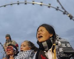
 Georgians Defy Government Crackdown After Year of Protests
 Tokyo court rules Japan’s same-sex marriage ban constitutional
 American Mother Extradited From UK to U.S. on Murder Charges
 Facebook Slow to Remove Bondi Attack Praise, Anti-Hate Group Claims
 Albanese Opens Door to Bondi Royal Commission Amid Rising Pressure
 Iran Protesters Defy Crackdown as Violent Clashes Intensify
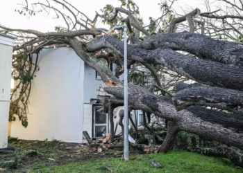 Storm Goretti leaves Cornwall homes without power
 US Clears Nvidia AI Chip Sales to China in Policy Shift
 Gulf states warn Trump Iran strikes risk wider Middle East war
 EU weighs response amid Greenland tariff crisis with Trump
 Sydney Shark Attack Surge Shocks Australia Beaches
 No Gas Boiler Ban as UK Warm Homes Plan Backs Heat Pumps
 EU Says US Ties Have Suffered ‘Big Blow’ After Greenland Crisis
 Devon hosts first high-density hydro power system
 US-Style Pickup Trucks Surge on UK Roads
 Videos reveal earlier clash before Alex Pretti shooting
 UK New Car Discounts Near £6,000 as Prices Are Slashed
 Israel Moves to Bar MSF From Gaza Operations
 Tragic Ski Lift Accident Claims Australian Snowboarder
 Wigan Dump Crisis Sparks Health and Safety Alarm
 Portugal Election Delivers Socialist Win as Far Right Surges
 Australian Families Leave Syrian Camp for Home
 SA Police Intensify Search in Gus Lamont Case
 Trump Attacks UK-California Energy Pact
 Andrew Arrest Sparks Republic Debate in Australia
 Farage Chagos Islands Row Sparks Fury
 Storm Hernando: Edinburgh Airport Flights Cancelled in US Travel Chaos
 Germany Faces Backlash Over Scrapped Renewable Heating Mandate
 Hilary Knight speaks out on Trump’s recent hockey remarks
 Has Europe truly learned from the failures of 2022?
 Social Media Trial: Woman Says Addiction Began at Six
 Trump Faces Questions Over Iran Conflict Plan
 Iran Civilian Deaths Surge Past 200 Amid Fear
 Herzog Asio meeting sparks security storm
 Trump rebukes Starmer over Iran strikes
 Middle East attacks intensify as Trump rejects Iran talks
 Iran-Iraq border airstrikes spark new tensions
 Petrol Prices Soar as Retailers Accused of Gouging Amid Global Tension
 Penny Wong silent on Australian crew in sub strike
 Australians on US Submarine in Iranian Warship Strike
 Oil Prices Surge Above $100 Amid Iran War
 India T20 World Cup Triumph Seals Historic Title Defence
 Trump Pressures Congress Over Save America Act
 Iranian Football Squad Asylum Drama Shocks Australia
 Goma Drone Attack Kills Three as Conflict Escalates
 Queensland Protest Laws Spark Free Speech Backlash
 Eswatini Deal Sparks Global Outcry Over US Deportations
 Yvette Cooper: UK Must Follow Principles, Not US Pressure
 Trump Iran War Stance Hardens as Conflict Widens
 Iranian Captain Departs Australia Amid Asylum Tension
 Trump Nato threats expose Iran strategy vacuum
 Iran War Warning: Starmer Backs Ukraine Visit
 Iran World Cup Move Talks Raise Global Concerns
 Philippines energy emergency sparks coal power surge
 Australia Imposes Sudden Travel Ban on Iranian Visitors
 Trump Facing Backlash from Epstein Survivors Over Files


