

Published: 06 April 2026. The English Chronicle Desk. The English Chronicle Online.
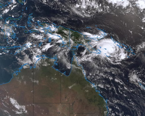
The tropical waters of the Coral Sea are once again stirring with a familiar and frightening intensity this week. Residents across far north Queensland find themselves looking toward the horizon with a deep sense of weary apprehension today. Recent reports from the Bureau of Meteorology suggest that a new threat is looming quite large over the coast. Severe Tropical Cyclone Maila is currently gathering significant strength as it moves through the warm Solomon Sea waters. This developing weather system threatens to strike the region just three weeks after another powerful storm hit. The memory of Severe Tropical Cyclone Narelle remains very fresh for many families living in the north. That previous storm left a trail of destruction that communities are still working hard to repair now.
On Monday morning the bureau confirmed that Maila was located roughly 590 kilometres west of Honiara city. The storm is currently classified as a category three system with very dangerous and powerful wind gusts. Experts have recorded these gusts reaching speeds of up to 185 kilometres per hour near the eye. Sustained winds are hovering around 130 kilometres per hour as the system slowly rotates in open water. For several days the storm has been performing strange circles between Papua New Guinea and the Solomon Islands. This erratic movement has made it quite difficult for many meteorologists to predict its exact future path. However the latest atmospheric data suggests a significant shift in its direction will occur very soon. Most models indicate that the storm will begin a south-westerly turn toward the Australian coastline midweek.

Helen Reid from the Bureau of Meteorology provided a sobering update regarding the potential for landfall soon. She noted that the most likely scenario involves the storm crossing the coast near Cape York. This specific area is still reeling from the impact of the previous category four storm last month. It would be a cruel blow for a region that has not yet finished basic cleanup. While the Cape York Peninsula remains the primary target researchers are not ruling out other paths. There is a possibility that the cyclone could swing further south toward more populated urban centres. Cities like Cairns and Townsville are being advised to monitor the situation very closely this week. Conversely there is also a slight chance that the system might miss the coast entirely later.
The uncertainty surrounding the storm is a major concern for emergency services and local residents alike today. Forecasting the exact strength and path of a cyclone involves many complex and shifting environmental variables. Reid emphasized that the jury is still out on exactly where the center will make landfall. The bureau expects the system to intensify into a category four storm within the next few days. This would mean sustained winds reaching between 160 and nearly 200 kilometres per hour at the core. Such force is capable of unroofing houses and causing widespread long-term damage to the local power grid. If it maintains this intensity it will pose a severe threat to both life and property. The warm ocean temperatures are currently providing the perfect fuel for this rapid and dangerous intensification.
Interestingly the same warm waters that powered Cyclone Narelle are now feeding this new atmospheric giant as well. Ocean temperatures have not had sufficient time to cool down since the last major storm passed through. The sea remains rich with the thermal energy required to sustain such a massive weather event now. Narelle was the strongest storm of the season so far when it struck on March twentieth. It carved a devastating path through remote areas and made landfall in three different Australian states. Such a feat has not been recorded by meteorologists in more than twenty-one long years until now. The fact that Maila follows so closely behind is a testament to the current climate conditions. Residents are finding it difficult to find the resources needed to prepare for another major hit.
Historical records show that severe cyclones in the month of April are somewhat rare for this region. The last time a major April storm crossed the Queensland coast was back in the year 2014. That system was known as Severe Tropical Cyclone Ita and it made landfall near the town of Cooktown. Like the current threat Ita brought heavy rainfall and damaging winds to the far north Queensland area. The current situation serves as a stark reminder of the volatile nature of the tropical storm season. People living in coastal communities are being urged to update their emergency kits and plans immediately. Local councils are also working to ensure that drainage systems are clear of any recent storm debris. Preparation is the only defense against the unpredictable power of a severe category four tropical cyclone.
The emotional toll on the community is becoming more apparent as the weekend forecast remains quite grim. Many farmers in the Cape York region are still assessing the damage to their crops from Narelle. Another hit could mean the total loss of harvests that have managed to survive the first round. Infrastructure such as roads and bridges may not withstand another massive surge of water and wind pressure. The bureau will continue to provide regular updates as the storm nears the Great Barrier Reef. Satellite imagery is being monitored every hour to catch any sudden changes in the storm’s central pressure. For now the people of Queensland can only wait and hope for a sudden change in direction. The next forty-eight hours will be critical in determining the true scale of the impending danger.

As the midweek approach begins the atmosphere across the north remains heavy with a sense of quiet dread. The sounds of hammers and saws are still echoing through many small towns as repairs continue daily. It is a race against time to secure properties before the winds begin to pick up speed. Authorities are reminding everyone to stay informed through official radio broadcasts and trusted online news platforms. Safety must remain the top priority for every individual and family in the potential path of Maila. Even if the storm weakens before landfall the expected rainfall could still cause significant flash flooding issues. The resilience of the Queensland people is legendary but this season is testing them like never before. Everyone is hoping for the best while preparing for the worst possible outcome this coming weekend.
In the coming days the turn toward the southwest will reveal the true intentions of this storm. If Maila continues to follow the current projections emergency evacuations may become necessary for some remote areas. The logistical challenge of moving people in the far north is always a significant and difficult task. Many communities are isolated by road even during moderate rain events due to the unique local geography. Helicopters and high-clearance vehicles are being placed on standby to assist with any urgent rescue operations. The government has promised that all necessary resources will be made available to those in the path. Despite the looming threat there is a strong sense of community spirit visible across the entire region. Neighbors are helping each other to clear yards and secure loose items that could become projectiles.
The scientific community is also watching this event with great interest due to its rare back-to-back nature. Having two severe category four systems strike the same area within a month is a statistical anomaly. It raises important questions about the long-term trends of tropical weather patterns in the southern hemisphere regions. For the average citizen however the focus remains purely on survival and protecting their homes and families. The beauty of the tropical north is often matched by its terrifying capacity for extreme weather events. As Monday draws to a close the eye of Maila remains over the deep blue sea. It is a calm before a potential storm that could rewrite the history books for this season. We will remain vigilant and continue to report on every development as this situation unfolds further.
Related News:
 Evacuations Ordered as California Wildfires Spread Fast
 Dutch Nationwide Fireworks Ban Expected to Transform New Year Traditions
 Dozens of Flood Warnings in England After Days of Non-Stop Rain
 Fast-moving Wildfires Rage Across Southwestern US
 As Trump Retreats from Climate Goals, China Is Becoming a Green Superpower
 Scotland’s Climate Plans Face Scrutiny Over ‘Science Fiction’ Targets
 Ocean Warming Drives Massive Marine Life Loss, Study Warns
 Tropical Flowers Shift Blooming Due to Climate Crisis
 UK Winter Nowhere Near a Record Breaker Despite Floods and Storms
 UK Records Warmest Day of the Year as Temperatures Exceed 18 °C
 UK Records Earliest Spring as Nature Awakens Fast
 ‘Extinct’ Antelope Returns to Sahara, Bringing Hope
 Eden Project Founder Celebrates 25 Years of Nature’s Hope
 Capitol Attack Anniversary Sparks Deep Political Divide
 Saudi Officials Report Zubaidi Flee Before Yemen Peace Talks
 UK Targets in New York Bomb Threat Hoax: Man Jailed
 Gambia Supreme Court Hears Case to Overturn FGM Ban
 Storm Goretti leaves Cornwall homes without power
 Trump targets Iran trade with 25% tariff warning
 US Senate rejects resolution limiting Trump military powers
 Gulf states warn Trump Iran strikes risk wider Middle East war
 Machado Trump medal gesture reshapes Venezuela power struggle
 Greenland defence seen as shared Nato duty amid troop arrivals
 Geopolitical football: Iran, Trump and the World Cup clash
 Canada-China trade gains momentum in new strategic partnership
 Trump Receives Machado’s Nobel Medal in White House Meeting
 Syria President Declares Victory as Ceasefire Reached with SDF
 US Considers Asylum for British Jews Amid Rising Antisemitism
 Trump slams UK ‘stupidity’ over Chagos Islands, eyes Greenland takeover
 No Gas Boiler Ban as UK Warm Homes Plan Backs Heat Pumps
 Shinzo Abe’s killer receives life sentence in Japan
 Record-Breaking Heat Looms Over South-East Australia as Catastrophic Fire Risk Escalates
 China General Under Investigation Amid Leadership Purge
 Philippines ferry disaster leaves 15 dead, dozens missing
 Devon hosts first high-density hydro power system
 US-Style Pickup Trucks Surge on UK Roads
 Cambridge Faces Scrutiny Over Arms Investment Transparency
 Wigan Dump Crisis Sparks Health and Safety Alarm
 What is Groundwater Flooding and Why Dorset is Seeing ‘Historical Highs’
 Epstein UAE Emails Shake British Royal Andrew’s Legacy
 Christchurch gunman seeks to vacate guilty plea
 Infantino Faces Russia Threat and Trump Concerns at Uefa Congress
 Concerns rise for Canberra boy amid Iran detention fears

 BRRRITAIN: Met Office Issues Yellow Weather Warning for More Snow
 Gentoo Penguins First Birds on Australian Territory Hit by Bird Flu
 Temperatures Dip Below Freezing as Arctic Air Sweeps Across the UK
 Flooding May Worsen Before It Improves as More Rain Forecast for the UK
 Storm Hernando: Edinburgh Airport Flights Cancelled in US Travel Chaos
 Caribbean Leaders Urge Dialogue Amid US Oil Embargo on Cuba
 Germany Faces Backlash Over Scrapped Renewable Heating Mandate
 Group Expands Legal Claim Over South West Water Pollution
 Greenpeace $345m Ruling Sparks Appeal Battle
 Ukraine Sends Drone Experts to Defend US Bases in Jordan
 New Zealand Covid Response Praised Despite Lingering Scars
 Abramovich Chelsea Sale Cash Faces Jersey Probe
 Net Zero by 2050 ‘Cheaper Than One Fossil Fuel Crisis’
 London Considers New SUV Charges to Improve Road Safety
 Yvette Cooper: UK Must Follow Principles, Not US Pressure
 Slovenia Election: A Nation at a Crossroads
 MPs Slam Agency Over Failing Fight Against Waste Dumping
 Jury Rules Meta and YouTube Liable for Addictive Design
 Saudi Arabia Urging US to Keep Up Iran Attacks
 Trump Softens Cuba Oil Stance as Russian Tanker Nears
 The Woman Guarding Earth From the Threat of Asteroids
 IMF Predicts Global Economic Crisis Due to Gulf Unrest
 California Defies Trump With Strict New AI Standards
 Germany Grapples With AI Abuse Following TV Star Scandal
 Exiled Tycoon Warns of New Russian Attacks on UK Soil
 Labor Under Fire Over Stalled University Fee Reform
 LA 2028: Millions of Affordable Olympic Tickets Announced
 Trump Slams Europe as Transatlantic Tensions Boil Over
 Inside the Deceptive Machine: A Former Producer Speaks Out
 Italy Faces Third Successive World Cup Absence After Loss
 Starmer Urges Ambitious EU Ties Amid Middle East Conflict
 Spain Faces Backlash Over Xenophobic Chants in Egypt Draw
 A Global Voice For Justice: Stephen Lewis Dies At Age 88
 Trump Issues Stark Warning After Strike On Iran’s Largest Bridge
 Red Skies and Raging Floods: One Dead as Storm Erminio and Saharan Dust Grip Greece
 Hope and Fear as Iranians Flee Across the Turkish Border


