

Published: 23 February 2026. The English Chronicle Desk. The English Chronicle Online.
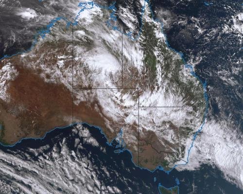
A powerful monsoon low is threatening to drench vast stretches of Australia’s interior, with forecasters warning that some regions could receive a year’s worth of rain within days. The unfolding monsoon low system has already triggered severe weather alerts across several states, raising fears of flash flooding and widespread disruption. Just weeks after record-breaking heat gripped inland communities, the dramatic shift has left residents bracing for another extreme weather event.
Australia’s Bureau of Meteorology has issued severe weather warnings covering north-western New South Wales, north-eastern South Australia, south-western Queensland and parts of Victoria. Meteorologists say the slow-moving monsoon low is drawing deep tropical moisture into areas that have endured prolonged dryness. Forecast models indicate that between 200mm and 300mm of rain could fall over parts of north-eastern South Australia and north-western New South Wales within days. More broadly, inland districts may record widespread totals of 100mm to 200mm.
Such figures are striking in landscapes more accustomed to dust and drought than persistent downpours. Senior Bureau meteorologist Dean Narramore described the projected totals as significant for regions that have struggled through a very dry year. In some towns, rainfall so far this year has barely registered. Now, forecasters warn that intense bursts of rain could fall within short periods, heightening the risk of flash flooding.

Communities including Tibooburra and areas north of Broken Hill in New South Wales are expected to see substantial rainfall. In Queensland, Birdsville is also in the path of the system. These remote towns are used to harsh extremes, yet the speed and scale of this event present fresh challenges. Authorities have urged residents to stay informed as conditions may change rapidly.
In South Australia’s outback, the small town of Marree could surpass its average annual rainfall in less than a week. Marree typically records about 142mm across an entire year. Yet during 2025, only 37mm fell in total, underscoring the severity of the recent dry spell. Residents also endured five consecutive days above 48C earlier this summer, highlighting the sharp contrast between heat and deluge.
Forecasters say thunderstorms embedded within the broader system could extend into central Victoria. Melbourne may experience heavy showers and isolated downpours as the weather band shifts eastwards. While February is traditionally among the wetter months for Sydney, several days of showers are forecast from midweek through to the weekend, adding to cumulative totals.
Transport networks have already felt the impact. The Indian Pacific passenger train, operated by Journey Beyond Rail, was forced to turn back towards Perth after floodwaters damaged sections of track. Parts of the line were reportedly washed away for distances approaching 100 metres. The disruption underscores the vulnerability of key infrastructure when heavy rainfall follows extended dry conditions.
The track in question forms part of the East West rail corridor managed by the Australian Rail Track Corporation. Inspection teams have been assessing damage near Broken Hill and Port Augusta. Early indications suggest repairs may take more than a week, particularly if further rainfall compounds existing problems. Officials warned that another significant system later this week could slow recovery efforts.
Road closures have also begun to mount. Several outback routes, including the Birdsville Track, were shut as floodwaters made travel unsafe. These closures can isolate communities, disrupt freight deliveries and affect access to essential services. Emergency authorities have advised travellers to reconsider non-essential journeys and monitor official updates.
Despite the disruption, meteorologists note that the rainfall will bring some longer-term benefits. Years of below-average precipitation have depleted aquifers, dams and rainwater tanks across inland districts. The current monsoon low is expected to recharge underground water reserves and replenish catchments. For farmers and pastoralists facing ongoing drought pressures, this replenishment could offer cautious optimism.
One of the most closely watched areas is Kati Thanda-Lake Eyre in northern South Australia. Heavy rain has been falling directly over the lake and across its vast catchment. Water from surrounding river systems is also expected to flow into the basin in coming days. If projections hold, the lake could fill significantly by next week, creating a rare and dramatic transformation of the arid landscape.
Recent rainfall records hint at the system’s potency. In the New South Wales Hunter region, Scone recorded 102.6mm at its airport in a single day, setting a new February record. Such intense daily totals illustrate how rapidly conditions can escalate when tropical moisture interacts with unstable air masses. Authorities continue to monitor river levels and issue updates as required.
The broader context of extreme weather remains central to public discussion. Climate scientists have repeatedly linked the increasing frequency of intense rainfall events to global heating. The warming climate allows the atmosphere to hold more moisture, which can then be released in heavier bursts. Australia has experienced a series of weather extremes in recent years, ranging from devastating bushfires to severe floods.
Communities across the affected states are now preparing for possible evacuations or temporary isolation. Local councils have activated emergency response plans, while state authorities coordinate resources. Residents have been advised to secure loose property, clear drainage areas and avoid driving through floodwaters. Experience from previous events shows that even shallow water can pose serious risks.
The psychological toll of rapid weather swings should not be underestimated. Many residents endured scorching temperatures only weeks ago, and some are still recovering from previous drought impacts. The sudden arrival of heavy rain can bring relief, yet it also generates anxiety about property damage and personal safety. Clear communication from meteorological services remains crucial.

Forecasters stress that predicting rainfall totals from a monsoon low can be challenging. Small shifts in the system’s path may concentrate heavier falls over particular districts. As the week progresses, updated modelling will refine expectations. However, the message remains consistent: residents in warned areas should stay alert and prepared.
While metropolitan centres such as Melbourne and Sydney may experience inconvenience, the most dramatic consequences are likely inland. Sparse infrastructure and vast distances complicate emergency responses in remote regions. Helicopters, satellite communications and community networks often play essential roles when roads become impassable.
For now, attention remains fixed on radar images and rainfall gauges. The monsoon low continues to funnel moisture across state borders, blurring the lines between relief and risk. In some towns, children may witness flowing creeks that have remained dry for years. In others, sandbags may line doorways as residents guard against encroaching water.
The coming days will reveal the full extent of the system’s impact. Whether the event proves transformative or merely disruptive, it serves as another reminder of Australia’s climatic volatility. From searing heat to torrential rain, extremes define life across much of the continent. As authorities coordinate responses and communities support one another, the resilience forged in past crises will again be tested.
For observers abroad, the scale of Australia’s interior can make such events seem distant. Yet for those living beneath darkening skies, the rumble of thunder carries immediate urgency. The monsoon low has reshaped forecasts and routines alike, leaving residents watchful and hopeful that preparation will mitigate harm.
Related News:
 Top Christmas Books Reads: Classics to Cozy Romcoms
 Just Stop Oil Protesters Convicted Amid Climate Defence Row
 BBC to Apologise Over Edited Trump Speech Amid Backlash
 Britain deploys RAF specialists to assist Belgium with drone threats
 Palace May Restore Hyphen to Andrew Mountbatten-Windsor’s Name
 US Senate Passes Funding Bill to End Historic Shutdown
 US Justice Department Files Lawsuit Against California Over Partisan Voting Maps
 Greene Pushes Epstein Files Amid Trump Fallout
 Trump Deploys DHS to Charlotte in Major Arrest Operation
 December Run-Off in Chile as Election Produces No Winner
 Zelenskyy Signs Fighter Jet Deal Amid Russian Drone Attacks
 Orban Says Ukraine Has ‘No Chance’ as EU Support Continues
 Canada Passes Carney’s First Budget in Tight Parliamentary Vote
 Israeli Strike Kills 13 Near Palestinian Camp in Lebanon
 Shadow Fleet at Sea: Europe’s Battle Against Illicit Oil Shipping
 Tiny Curacao Makes History as Smallest Nation to Reach World Cup
 Haiti Qualifies for World Cup Despite Coach Never Visiting Country
 Deadly Russian Strikes Hit Western Ukraine, 20 Killed in Ternopil
 Pentagon Officials in Ukraine to Discuss War End
 Ukraine Peace Plan: Zelensky Ready for Dialogue
 Vietnam Battles Deadly Floods as Rains Continue
 Venezuela Threatens Nobel Winner Machado with Fugitive Status
 At Least Three Dead in Bangladesh Earthquake
 Royal Navy Shadows Russian Warships Entering the Channel
 Israel Confirms Hamas Returned Dror Or’s Body
 US Suspends Afghan Immigration After White House Shooting
 Two National Guard Soldiers Critically Injured Near White House
 Georgians Defy Government Crackdown After Year of Protests
 Southern Lebanon reels as Israeli strikes shatter communities
 Mbappe Scores 4 as Real Madrid Edge Olympiakos
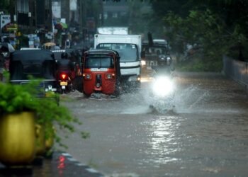 Sri Lanka Floods Leave 56 Dead, Dozens Missing
 Tokyo court rules Japan’s same-sex marriage ban constitutional
 ‘Extinct’ Antelope Returns to Sahara, Bringing Hope
 EU plans $105bn Ukraine aid using frozen Russian assets
 Global campaign launched to free Palestinian leader Barghouti
 American Mother Extradited From UK to U.S. on Murder Charges
 Khaleda Zia, Bangladesh’s First Female Prime Minister, Dies at 80
 Russia losses Ukraine war peace talks intensify amid rising deaths
 Facebook Slow to Remove Bondi Attack Praise, Anti-Hate Group Claims
 Australian Cruise Ship Freed After Reef Grounding in Papua New Guinea
 Zelenskyy Accuses Russia of Sabotaging Peace Talks
 US Cities Erupt in Protests Against Trump’s Venezuela Military Action
 Albanese Opens Door to Bondi Royal Commission Amid Rising Pressure
 Trump Escalates Minnesota Immigration Surge Amid Rising Tensions
 Iran Protesters Defy Crackdown as Violent Clashes Intensify
 US Clears Nvidia AI Chip Sales to China in Policy Shift
 Trump Threatens Strong Action If Iran Executes Protesters
 Gulf states warn Trump Iran strikes risk wider Middle East war
 Machado Trump medal gesture reshapes Venezuela power struggle
 Greenland defence seen as shared Nato duty amid troop arrivals
 Trump Receives Machado’s Nobel Medal in White House Meeting
 EU weighs response amid Greenland tariff crisis with Trump
 Syria President Declares Victory as Ceasefire Reached with SDF
 US Considers Asylum for British Jews Amid Rising Antisemitism
 Sydney Shark Attack Surge Shocks Australia Beaches
 ICE street raids expose a chilling future for public freedoms
 Thousands Flee Cambodia Scam Centres Amid Global Pressure
 EU Says US Ties Have Suffered ‘Big Blow’ After Greenland Crisis
 Andrew Hastie Emerges as Leadership Rival to Ley
 Starmer China visit raises human rights pressure on Beijing
 US Launches Multi-Day Air Drills Amid Rising Iran Tensions
 Videos reveal earlier clash before Alex Pretti shooting
 China Executes 11 Linked to Myanmar Scam Networks
 UK New Car Discounts Near £6,000 as Prices Are Slashed
 Israel Moves to Bar MSF From Gaza Operations
 Tragic Ski Lift Accident Claims Australian Snowboarder
 Thousands Left Without Heating in Ukraine Amid Russia Strikes
 Trump Praises ‘Terrific’ Petro After White House Talks
 Portugal Election Delivers Socialist Win as Far Right Surges
 Sydney Protest Escalates and Elderly Woman Suffers Severe Injury
 Tarique Rahman’s Rise Toward Bangladesh’s Top Job
 Australian Families Leave Syrian Camp for Home
 SA Police Intensify Search in Gus Lamont Case
 Trump Attacks UK-California Energy Pact
 Kim Jong-un Unveils Housing for War Families
 Trump and Chagos Deal Rift Over Iran Strikes
 Andrew Arrest Sparks Republic Debate in Australia
 Global corruption crisis: Who Washington shields
 El Mencho Killed as Mexico Faces Violence
 Farage Chagos Islands Row Sparks Fury


