

Published: 27 March 2026. The English Chronicle Desk. The English Chronicle Online.
The intense power of Cyclone Narelle has caused widespread devastation across the vast coastline of Western Australia today. Residents in several coastal communities are now dealing with the aftermath of terrifying wind gusts and heavy rain. Many families watched in horror as strong winds tore the roofs off their sturdy family homes. Hundreds of properties have lost electricity as the storm continues to move through the Gascoyne region. Emergency services have been working tirelessly to ensure the safety of everyone in the impact zone. This massive storm has already traveled across the northern parts of Australia over the last week. It initially struck Queensland as a category four system before moving into the Northern Territory. Now the people of Western Australia are facing the full brunt of this natural disaster.
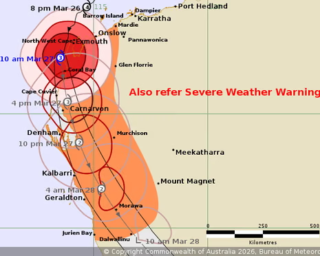
The weather system weakened slightly to a category three storm by late Friday morning local time. Despite this slight reduction in intensity, the storm produced dangerous wind gusts reaching 220km/h near Exmouth. The local emergency center in Exmouth actually suffered significant damage during the peak of the storm. Officials had to move people seeking shelter to a nearby church for their own safety. The Shire President, Matthew Niikkula, described the experience as truly terrifying for the local community members. He noted that many people will be very emotional as they assess the property damage. Driving rain has flooded many houses while horizontal winds shook the foundations of large buildings. One boat reportedly sank in the canals of Exmouth due to the rising water levels.

In the tourist town of Carnarvon, more than six hundred properties were left without any power. Horizon Power crews are waiting for conditions to improve before they can safely begin repairs. The storm is expected to make another landfall near Carnarvon during the Friday afternoon period. Residents in Denham have also bunkered down and completed sandbagging to protect their local businesses. The streets of Denham were described as eerie and deserted as the red alert began. Schools across the state remained closed on Friday to keep children and staff members safe. More than fifty educational facilities were affected by the safety closures throughout the coastal regions. Road closures are also in effect across the Pilbara to prevent travelers from entering danger.
The Bureau of Meteorology has been tracking Cyclone Narelle very closely as it moves south. Meteorologist Ilana Cherny explained that the storm might cross the coast near the Cape Cuvier area. If the system remains offshore longer, it could impact the Shark Bay region later tonight. Very destructive wind gusts of up to 250km/h are possible along the coast near Coral Bay. This specific weather event is quite rare due to its long and destructive path. It is the first system in twenty years to hit three different Australian states. The last storms to achieve this were Cyclone Ingrid and the very famous Cyclone Steve. Scientists suggest that record ocean temperatures in the Coral Sea helped fuel this massive storm. Global heating is frequently cited as a reason for such rapid and intense storm formations.
Perth is also feeling the indirect effects of the storm with heavy rainfall arriving early. Locations such as Bickley and Swanbourne have already recorded over 30 millimetres of rain today. The city could see up to 100 millimetres of rain over the coming weekend period. This amount of precipitation often leads to dangerous flash flooding in the metropolitan Perth area. A flood watch has been officially issued from the north-west Cape down to Swan River. Some residents further south in Dawesville have only seen cloudy skies and small local thunderstorms. However, they are preparing for the rain that is forecast to arrive on Saturday evening. The state government has pre-deployed emergency generators to Geraldton to help with the recovery.
Prime Minister Anthony Albanese stated that the federal government stands ready to provide urgent assistance. He spoke about the importance of supporting local governments during these difficult natural disaster events. Premier Roger Cook noted that it will take some time to determine the full extent. Emergency teams have already received dozens of calls for assistance across the entire Pilbara region. Many people who evacuated their homes are now returning to find scattered debris and wreckage. The clean-up efforts are expected to last well into next week for many northern towns. Cyclone Narelle is forecast to move into the Southern Ocean by late Saturday night. The transition into a tropical low should hopefully reduce the wind speeds for inland residents.
The psychological impact of such a strong storm can be very difficult for small communities. Many locals in the Gascoyne region have never experienced winds of this specific extreme magnitude. The sound of lifting roofs and crashing debris has left many residents feeling quite shaken. Emergency workers are prioritizing the restoration of essential services like water and electricity for everyone. They are also clearing fallen trees from main roads to allow for emergency vehicle access. The community spirit remains strong as neighbors help each other clear away the heavy debris. Local businesses in tourist areas are worried about the impact on the upcoming holiday season. Much of the infrastructure in Shark Bay will require significant repairs before tourists can return.
The environmental impact of the storm on the world heritage-listed Shark Bay is also concerning. Strong surges and heavy rain can damage delicate marine ecosystems and coastal vegetation in the area. Wildlife rescuers are on standby to help any animals displaced by the flooding or winds. The Department of Fire and Emergency Services continues to provide regular updates via their website. Residents are encouraged to stay indoors until the official all-clear is given by authorities. The unpredictable nature of the storm means that conditions can change very rapidly indeed. Safety remains the number one priority for all government agencies involved in the response. Further rainfall totals will be monitored closely as the system passes through the southern districts.

As the sun sets on Friday, the wind continues to howl across the rugged coastline. The resilience of the Western Australian people is being tested by this record-breaking weather event. Families are huddled together with torches and candles while they wait for the storm to pass. The heavy rain creates a constant drum beat on the metal roofs that remain intact. Tomorrow will bring a clearer picture of the path of destruction left by Cyclone Narelle. For now, the focus remains on keeping people safe and warm during the long night. The English Chronicle will continue to provide updates as more information becomes available. Our thoughts are with those who have lost their homes or businesses today.
The history of Australian cyclones shows that recovery is often a slow and steady process. It takes a lot of coordination between different levels of government and the local community. The damage to the power grid in the north is particularly extensive this time around. Western Power has reported dozens of active outages that require specialized equipment to fix properly. Some remote properties may be without power for several days due to the road conditions. Helicopter surveys will likely begin on Saturday morning to check on isolated cattle stations. These stations often face the worst of the flooding without any immediate physical help available. The scale of the Western Australian landscape makes the rescue operations very challenging for teams.
Despite the destruction, there have been no reports of serious injuries or deaths so far. This is a testament to the effectiveness of the early warning systems and evacuations. People took the warnings seriously and prepared their homes as best as they possibly could. The experience gained from previous storms helped the emergency services manage the situation with professionalism. As Cyclone Narelle eventually fades away, the lessons learned will help prepare for future weather events. The climate continues to change, making these powerful storms a more frequent reality for Australia. For the residents of the west coast, tonight is about survival and waiting for morning. The strength of the community will be the foundation for the rebuilding process next week.
Related News:
 Storm Hernando: Edinburgh Airport Flights Cancelled in US Travel Chaos
 Storm Hernando: Edinburgh Airport Flights Cancelled in US Travel Chaos
 UK Must Act with Courage and Clarity on Israel-Palestine Conflict, Says Foreign Affairs Committee Report
 Radioactive Leak at UK’s Nuclear Warhead Base Sparks Outcry Over Safety and Secrecy
 Mutual Inconvenience: Why Alaska Was Chosen for the Trump-Putin Summit on Ukraine
 Terence Stamp, ’60s British Film Legend and Star of Superman, Dies at 87
 Where Is Prince William and Kate Middleton’s New House? Inside the Historic Lodge Set to Become Their ‘Forever Home’
 FIFA Eyes Biennial Club World Cup from 2029, Plans Possible Expansion
 EuroMillions Record-Breaking £210m Jackpot Won by Lucky Lottery Ticket Holder
 Is the UK Ready to Put Boots on the Ground in Ukraine? Assessing Military Capacity and Challenges
 Shein UK Faces Allegations of Shifting Majority of Profits to Singapore to Reduce UK Tax
 British Couple Among 16 Killed in Lisbon Funicular Tragedy
 Protests Expected as Israeli Arms Firms Join Global Defence Trade Fair in London
 Serbia Humiliated 0-5 by England in World Cup Qualifier
 Thousands Gather in London to Protest Donald Trump’s Second UK State Visit
 Trump Urges UK to “Call Out the Military” to Secure Borders Amid State Visit
 British AI Startup Outshines Human Forecasters in Global Prediction Contest
 Liverpool Vs outhampton Set for Carabao Cup Clash at Anfield
 UK Fighter Jet Purchase Could Breach Nuclear Treaty, Warns CND
 A Third of EU Citizens in UK Report Discrimination by Public Bodies Post-Brexit
 Public Trust in SNP Hits Historic Low Amid NHS Concerns
 Cooper Unveils £4m Cyber Plan Against Russian Hackers
 Johnson Suggests Mandelson Linked to China Spy Controversy
 Witness statements reveal the CPS China spy row collapse in the UK
 China warns UK over delayed London mega embassy decision
 Rachel Reeves signals welfare reform ahead of key budget
 Kosovo agrees to host Britain’s refused asylum seekers
 Fabio Wardley stuns Joseph Parker to earn Usyk title shot
 British Woman in Iran ‘Losing Hope’ Amid Ongoing Detention
 Johnson Approved China’s London ‘Super-Embassy’ in 2018
 Top Christmas Books Reads: Classics to Cozy Romcoms
 Just Stop Oil Protesters Convicted Amid Climate Defence Row
 I’m a Celebrity 2025 line-up revealed: Osbourne joins
 Palace May Restore Hyphen to Andrew Mountbatten-Windsor’s Name
 Royal Navy Shadows Russian Warships Entering the Channel
 “Enough is Enough”: Local MP Vows to Fight Rainham Quarry Plans
 ‘Extinct’ Antelope Returns to Sahara, Bringing Hope
 Local Fish Could Boost UK Health and Economy Significantly
 Storm Goretti leaves Cornwall homes without power
 Robo-Vaccination Could Transform Fight Against Bovine TB
 No Gas Boiler Ban as UK Warm Homes Plan Backs Heat Pumps
 UK joins North Sea wind grid pact with nine European nations
 Devon hosts first high-density hydro power system
 Starmer China visit raises human rights pressure on Beijing
 UK New Car Discounts Near £6,000 as Prices Are Slashed
 Wigan Dump Crisis Sparks Health and Safety Alarm
 What is Groundwater Flooding and Why Dorset is Seeing ‘Historical Highs’
 Dozens of Flood Warnings in England After Days of Non-Stop Rain
 Universities and Politicians Briefed on China and Russia Spy Threat
 Temperatures Dip Below Freezing as Arctic Air Sweeps Across the UK
 Snow and Rain Warnings as Cold Snap Continues in the UK
 Flooding May Worsen Before It Improves as More Rain Forecast for the UK
 Dual Nationals Face Scramble for UK Passports as New Rules Come Into Force
 Shutting North Sea ‘Will Drive Up Carbon Emissions’
 Trump and Chagos Deal Rift Over Iran Strikes
 How Much Could Andrew’s Arrest Hurt the Royal Family?
 Fly-Tippers to Be Hunted by ‘Drone Squad’ in Crackdown from the Sky
 Australian PM Says Former Prince Andrew Has Suffered ‘Extraordinary Fall’ but That Won’t Prompt Republic Referendum
 Farage Chagos Islands Row Sparks Fury
 US Will Not Back Out of Tariff Deals with UK and Others, Says Trump Trade Representative
 Trump Tariffs Threat Spark UK and EU Alarm
 ‘We’ve been paying for happy endings for Andrew for years’: inside the royal disgrace, biographer says
 Group Expands Legal Claim Over South West Water Pollution
 Greenpeace $345m Ruling Sparks Appeal Battle
 RAF Responding to Suspected Drone Strike at UK Cyprus Base
 Islanders Advised on Travel to Middle East Amid Escalation
 Brit ‘in Good Spirits’ Amid Dubai Missile Attacks, Stranded but Safe
 Trump rebukes Starmer over Iran strikes
 Stranger ‘On Drugs’ Stabbed Saudi Student to Death in Cambridge
 Minister Meets Crews Who Will ‘Take Out’ Iranian Drones
 ‘We Must Finish This’: Israelis Rally Behind War Effort as Iran Strikes Tel Aviv
 UK Prepares Aircraft Carrier for Middle East Crisis
 UK–US Tensions Ease as Starmer and Trump Hold First Call Since Iran Row
 Yvette Cooper: UK Must Follow Principles, Not US Pressure
 Iran War Warning: Starmer Backs Ukraine Visit
 UK Wage Growth Slows as Jobs Market Holds Firm
 MPs Slam Agency Over Failing Fight Against Waste Dumping
 Australia Imposes Sudden Travel Ban on Iranian Visitors
 UK Forces Ready to Seize Russian Shadow Fleet Vessels


