


Published: 06 February 2026. The English Chronicle Desk. The English Chronicle Online.
Storm Leonardo continues to cause severe disruption across parts of Europe and northern Africa, as emergency teams struggle with flooding, damage, and mass evacuations. The powerful weather system has moved slowly across the region, increasing rainfall totals and intensifying risks for vulnerable communities. Authorities in several countries have issued top-level alerts, while rescue operations remain active in multiple locations. The scale of the Storm Leonardo impact has drawn urgent attention from meteorological agencies and disaster response units across affected zones.
The Iberian peninsula remains one of the worst hit areas, with Spain and Portugal facing relentless rain and dangerous winds. Weather officials confirm that the system has stalled, which has allowed rainfall totals to build rapidly over several days. In southern Spain, the mountain town of Grazalema recorded more than 700 millimetres of rain since midweek. That figure is close to what many areas normally receive over an entire year. Rivers have burst their banks, rural roads have vanished under water, and farmland has turned into temporary lakes.

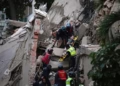
Regional authorities across Andalucía ordered widespread evacuations as water levels rose near residential zones and transport corridors. Around 3,500 residents have been moved from risk areas into temporary shelters and municipal facilities. Schools closed across several districts, and rail and bus services were suspended due to unsafe conditions. Local officials described the situation as fast changing and highly dangerous, especially near rivers and steep valleys. The human toll remains uncertain as search teams continue to check flooded neighbourhoods and damaged vehicles.
Spain’s national weather agency issued its highest red warning level for parts of Cádiz and Málaga provinces. Forecasters measured around 150 millimetres of rainfall within only twelve hours in some locations. Such rainfall intensity overwhelms drainage systems and increases the speed of surface runoff. Emergency services reported multiple water rescues involving drivers trapped inside vehicles and families stranded in homes. In Málaga province, responders continue searching for a missing girl believed swept away by a swollen river channel during peak flooding.
Portugal is also facing renewed danger while still recovering from a deadly storm system last week. Saturated ground conditions made the country more vulnerable to fresh downpours linked to the same circulation pattern. Floodwaters entered homes, damaged bridges, and triggered landslides in hilly terrain across central and southern regions. Officials confirmed that more than 200 people were evacuated as a precautionary measure. In the Alentejo region, a man died after his car was carried away by fast moving floodwater during night hours.
Meteorologists explain that the unusual behaviour of the current system is linked to large scale atmospheric patterns. A southward shifted jet stream has helped trap the storm over the same general zone for days. At the same time, a long plume of tropical moisture has fed into the circulation. This process, often called an atmospheric river, continuously supplies new rainfall energy into the storm core. Because soils were already wet after weeks of unsettled weather, runoff increased quickly and worsened flood severity.
The continuing Storm Leonardo pattern shows how slow moving systems can produce more damage than faster, more intense storms. Duration often matters more than peak wind speed when it comes to flooding disasters. Hydrologists warn that even moderate additional rainfall could trigger new river surges in southern Spain. Reservoir managers are releasing controlled volumes of water to protect dam structures from excessive pressure. That action reduces one risk but can increase downstream river levels temporarily.
Beyond Europe, northern Morocco has also experienced serious consequences from the same broad weather setup. Overflowing rivers and stressed reservoirs forced very large scale precautionary evacuations in several districts. Government sources estimate that more than 100,000 people have been moved from exposed floodplain communities. The city of Ksar El-Kebir stands among the hardest hit urban areas so far. Streets filled with muddy water, and local markets and workshops reported heavy losses to stock and equipment.
Infrastructure strain is becoming another major concern as the emergency continues into a new phase. Power interruptions, damaged road surfaces, and weakened bridges complicate relief and supply movements. Aid groups are coordinating with local authorities to deliver food, blankets, and medical support to shelters. Public health teams are also watching for water contamination risks after floodwater entered distribution networks. Quick testing and temporary treatment units are being deployed where necessary.
Forecast models suggest that Storm Leonardo will remain near the north west of the Iberian region for several more days. Northern and central Portugal could receive another 150 to 250 millimetres of rain before conditions improve. That projection has prompted pre-emptive closures and travel advisories across exposed districts. Officials are urging residents to avoid unnecessary journeys and respect road closure barriers. Experience shows that many flood fatalities occur when drivers attempt to cross moving water.
While Europe and North Africa face flooding danger, another tropical system has been active in Southeast Asia. Tropical Storm Penha developed over the Philippine Sea and tracked west toward Mindanao this week. The system produced strong wind gusts and intense rainfall as it approached land. Coastal zones prepared for storm surge heights reaching up to two metres in some areas. Inland provinces also received heavy rain warnings due to flash flood and landslide threats.

Related News:
 British Woman in Iran ‘Losing Hope’ Amid Ongoing Detention
 BBC Journalist Held and Interrogated in Vietnam
 UK University Suspends Human Rights Research Following Pressure from China
 Top Christmas Books Reads: Classics to Cozy Romcoms
 World Whisky Tour: 9 Global Gems
 Just Stop Oil Protesters Convicted Amid Climate Defence Row
 Tension and Turmoil at Aston Villa v Maccabi Match
 BBC to Apologise Over Edited Trump Speech Amid Backlash
 Lando Norris Dominates Brazil GP to Strengthen F1 Title Bid
 Britain deploys RAF specialists to assist Belgium with drone threats
 Palace May Restore Hyphen to Andrew Mountbatten-Windsor’s Name
 US Senate Passes Funding Bill to End Historic Shutdown
 Suicide Bombing at Islamabad Court Kills 12, Injures Dozens
 Hitler’s DNA Confirms He Truly Had Only One Testicle
 US Justice Department Files Lawsuit Against California Over Partisan Voting Maps
 Oklahoma Governor Grants Last-Minute Clemency to Death Row Inmate
 Greene Pushes Epstein Files Amid Trump Fallout
 Trump Deploys DHS to Charlotte in Major Arrest Operation
 December Run-Off in Chile as Election Produces No Winner
 Zelenskyy Signs Fighter Jet Deal Amid Russian Drone Attacks
 Orban Says Ukraine Has ‘No Chance’ as EU Support Continues
 Canada Passes Carney’s First Budget in Tight Parliamentary Vote
 Israeli Strike Kills 13 Near Palestinian Camp in Lebanon
 Zelensky Meets US Envoy in Turkey to Push Ukraine Peace Talks
 Shadow Fleet at Sea: Europe’s Battle Against Illicit Oil Shipping
 Tiny Curacao Makes History as Smallest Nation to Reach World Cup
 Haiti Qualifies for World Cup Despite Coach Never Visiting Country
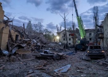 Deadly Russian Strikes Hit Western Ukraine, 20 Killed in Ternopil
 Pentagon Officials in Ukraine to Discuss War End
 Ukraine Peace Plan: Zelensky Ready for Dialogue
 Vietnam Battles Deadly Floods as Rains Continue
 Venezuela Threatens Nobel Winner Machado with Fugitive Status
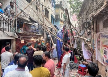 At Least Three Dead in Bangladesh Earthquake
 Royal Navy Shadows Russian Warships Entering the Channel
 Israel Confirms Hamas Returned Dror Or’s Body
 US Suspends Afghan Immigration After White House Shooting
 Two National Guard Soldiers Critically Injured Near White House
 Georgians Defy Government Crackdown After Year of Protests
 Southern Lebanon reels as Israeli strikes shatter communities
 Mbappe Scores 4 as Real Madrid Edge Olympiakos
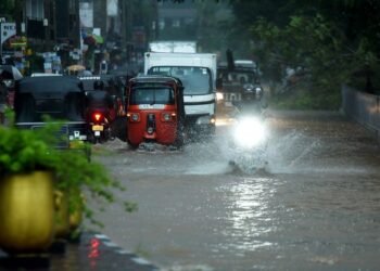 Sri Lanka Floods Leave 56 Dead, Dozens Missing
 India’s Labour Law Overhaul Sparks Fierce Debate
 Tokyo court rules Japan’s same-sex marriage ban constitutional
 ‘Extinct’ Antelope Returns to Sahara, Bringing Hope
 EU plans $105bn Ukraine aid using frozen Russian assets
 Global campaign launched to free Palestinian leader Barghouti
 American Mother Extradited From UK to U.S. on Murder Charges
 Khaleda Zia, Bangladesh’s First Female Prime Minister, Dies at 80
 Russia losses Ukraine war peace talks intensify amid rising deaths
 Facebook Slow to Remove Bondi Attack Praise, Anti-Hate Group Claims
 Australian Cruise Ship Freed After Reef Grounding in Papua New Guinea
 Zelenskyy Accuses Russia of Sabotaging Peace Talks
 US Cities Erupt in Protests Against Trump’s Venezuela Military Action
 Albanese Opens Door to Bondi Royal Commission Amid Rising Pressure
 Trump Escalates Minnesota Immigration Surge Amid Rising Tensions
 Iran Protesters Defy Crackdown as Violent Clashes Intensify
 US Clears Nvidia AI Chip Sales to China in Policy Shift
 Trump Threatens Strong Action If Iran Executes Protesters
 Gulf states warn Trump Iran strikes risk wider Middle East war
 Machado Trump medal gesture reshapes Venezuela power struggle
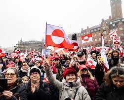
 Greenland defence seen as shared Nato duty amid troop arrivals
 Trump Receives Machado’s Nobel Medal in White House Meeting
 EU weighs response amid Greenland tariff crisis with Trump
 Syria President Declares Victory as Ceasefire Reached with SDF
 US Considers Asylum for British Jews Amid Rising Antisemitism
 Sydney Shark Attack Surge Shocks Australia Beaches
 ICE street raids expose a chilling future for public freedoms
 Thousands Flee Cambodia Scam Centres Amid Global Pressure
 EU Says US Ties Have Suffered ‘Big Blow’ After Greenland Crisis
 Andrew Hastie Emerges as Leadership Rival to Ley
 Starmer China visit raises human rights pressure on Beijing
 Arizona border shooting leaves suspect hospitalised after agent pursuit
 US Launches Multi-Day Air Drills Amid Rising Iran Tensions
 Videos reveal earlier clash before Alex Pretti shooting
 China Executes 11 Linked to Myanmar Scam Networks
 UK New Car Discounts Near £6,000 as Prices Are Slashed
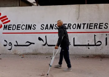 Israel Moves to Bar MSF From Gaza Operations
 Tragic Ski Lift Accident Claims Australian Snowboarder
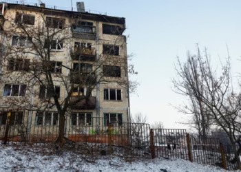 Thousands Left Without Heating in Ukraine Amid Russia Strikes
 Trump Praises ‘Terrific’ Petro After White House Talks


