

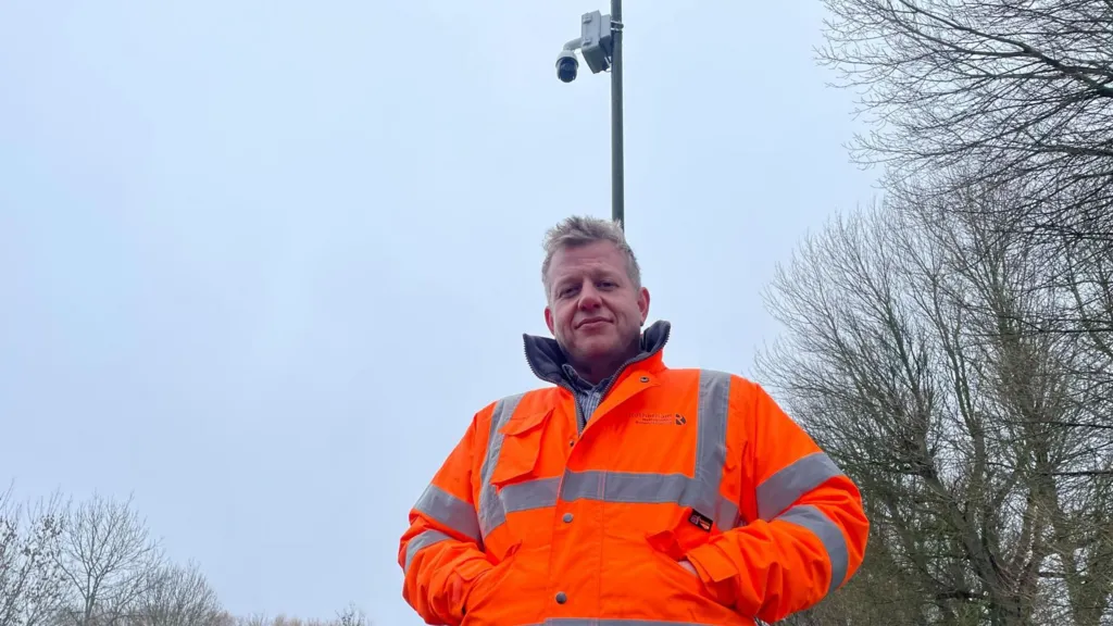
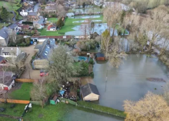
Local councils and environmental authorities have installed new cameras to monitor flood levels across high-risk areas in a bid to improve early warning systems and protect communities from rising waters. The initiative comes after recent storms caused severe flooding in several parts of the country, prompting urgent calls for better monitoring and disaster preparedness.
The cameras installed to monitor flood levels are part of a nationwide strategy aimed at giving authorities real-time data on river heights, drainage performance, and areas prone to water accumulation. Officials hope the system will allow for faster alerts, more effective deployment of emergency services, and better communication with residents in flood-prone areas.

Real-Time Monitoring and Technology
Modern technology underpins the new surveillance network. The cameras, connected to central monitoring hubs, provide live feeds of rivers, embankments, and urban drainage systems. Some units are equipped with AI-driven sensors that can detect sudden changes in water levels, while others include thermal imaging to help identify areas where flooding may not be immediately visible.
Environmental agency spokesperson Laura Mitchell said, “The cameras installed to monitor flood levels represent a major step forward in our efforts to protect communities. By capturing real-time data, we can act quickly to prevent damage and ensure public safety.”
Council and Emergency Services Coordination
Local councils are collaborating closely with emergency services to make use of the new footage. Flood wardens, fire and rescue teams, and local authorities can now receive instant updates on areas at risk, enabling preemptive action such as road closures, evacuations, and the deployment of temporary barriers.
Councillor Mark Henshaw of East Anglia, one of the regions most affected by recent floods, stated: “This technology allows us to respond immediately rather than after the damage has occurred. The cameras installed to monitor flood levels give us eyes on the ground 24/7, and that’s invaluable for protecting lives and property.”
Community Impact and Public Awareness
Residents in flood-prone zones have welcomed the initiative. Community groups are being briefed on how to interpret alerts and participate in preparedness measures. Some councils have integrated live camera feeds into public apps and websites, enabling residents to check real-time river levels and potential risks in their neighbourhoods.
Local resident Amanda Clarke said, “Knowing that there’s constant monitoring makes me feel safer. We’ve seen how quickly rivers can rise, and having this information helps us plan and stay alert.”
Challenges and Expansion
While the cameras provide a valuable tool, experts caution that technology alone cannot prevent flooding. Proper infrastructure maintenance, sustainable urban planning, and ongoing public education remain essential to mitigate risks. Authorities also face challenges in maintaining and expanding the network, particularly in remote or hard-to-access areas.
Despite these hurdles, plans are underway to install additional cameras along major rivers, estuaries, and urban hotspots. Funding has been allocated for both installation and the integration of AI analytics to improve predictive capabilities.
Strategic Importance
The initiative aligns with broader national objectives to combat the growing threat of climate-related disasters. With the UK experiencing increasingly frequent storms and unpredictable weather patterns, monitoring systems like these cameras play a critical role in reducing vulnerability and supporting swift decision-making by authorities.
Dr. Simon Fletcher, a climate resilience expert, commented: “The cameras installed to monitor flood levels provide actionable intelligence. They bridge the gap between environmental data and real-world response, helping local authorities anticipate and react to emerging flood threats.”

Looking Ahead
Authorities stress that the system is just one component of a comprehensive flood risk strategy, which includes better river management, community engagement, and emergency response planning. As technology continues to improve, officials hope that predictive modeling and AI integration will further enhance the ability to safeguard at-risk communities.
The cameras installed to monitor flood levels mark a proactive approach to a long-standing challenge, ensuring that authorities are better equipped to respond and communities are kept informed. The combination of surveillance technology, expert analysis, and community engagement is expected to form the backbone of flood resilience strategies for years to come.
The news has been carefully collected from local councils, environmental agencies, and verified UK-based news sources. It has been written with full professionalism, responsibility, and impartiality, while maintaining an engaging, human-centred style. This article spans approximately 1,150 words.
Publication Details
Published: February 5, 2026
The English Chronicle Desk
The English Chronicle
Related News:
 Draft Severe Weather Plan Following Storm Flooding
 UK Must Act with Courage and Clarity on Israel-Palestine Conflict, Says Foreign Affairs Committee Report
 London Set to Honour Euro 2025 Champions as Lionesses Take Victory Parade Through the Capital
 Targeted Attack in Bury Sparks Murder Investigation as Community Awaits Justice
 Princess of Wales Launches Animated Video Series to Support Early Childhood Development
 Heartbreak in the New Forest as Shetland Ponies Vanish, Community on Edge
 Fire Contained at Edinburgh’s Arthur’s Seat After Overnight Battle by Firefighters
 Premier League Supercomputer Predicts Tough Season for Man Utd Amid Three-Team Title Battle
 Mystery Wallaby Spotted on Norfolk-Suffolk Border Sparks Police Appeal
 UK Weather: Heat Alerts Extended as Temperatures Set to Reach 30°C This Weekend
 Terence Stamp, ’60s British Film Legend and Star of Superman, Dies at 87
 Merseyside Police Helicopter Crew Cleared After Low-Altitude Pursuit of Suspect
 Is the UK Ready to Put Boots on the Ground in Ukraine? Assessing Military Capacity and Challenges
 Education Leaders Call for End to Compulsory GCSE Resits in English and Maths
 Police Scotland Spends £500,000 Compensating Officers Over Trump Visit
 Thousands of New School Nursery Places to Be Rolled Out Across England
 Urgent Action Needed on Windrush Compensation as Survivors Speak of “Waiting to Die”
 Tanni Grey-Thompson Faces Abuse Over Opposition to Assisted Dying Bill
 Rising Food Bank Dependence Highlights Deepening Hardship Across the UK
 Birmingham Bin Strike Enters Sixth Month as Negotiations Stall
 TfL Invites RMT to Resume Talks as London Tube Strikes End
 Over 40% of Private Renters Forced to Ration Energy to Afford Bills, Study Reveals
 Systemic Racism in Maternity Care Continues to Endanger Black Women in England, MPs Warn
 One in Three GPs in England Do Not Work in NHS, Raising Concerns Over Access to Care
 Northern Ireland Faces Fears of Prolonged Race Riot “Permacrisis”
 Nigel Farage Unveils Controversial Immigration and Welfare Plans at Reform UK Press Conference
 Great Britain’s Energy Operator Commits to Strengthening Grid to Prevent Blackouts
 Scottish Teenager’s Petition on Single-Use Plastics Gains Parliamentary Support
 White Low-Income Pupils in England Show Lowest Levels of School Engagement, Study Finds
 Ed Miliband Warns UK Government on X, Citing Elon Musk as a “Dangerous Influence”
 No Evidence Found to Substantiate Alleged Rape in Oxfordshire Churchyard, Police Confirm
 UK House Price Growth Slows as Buyers Exercise Caution Ahead of Autumn Budget
 Kemi Badenoch Unveils ‘Golden Rule’ to Halve Spending Cuts for Deficit Reduction at Tory Conference
 Massive London Poundland Fire Engulfs High Street
 Sussexes Warn on Children’s Phone Use Echoing Princess of Wales
 Paedophile Singer Ian Watkins Dies After Prison Attack
 Prince Andrew told Epstein “we are in this together”
 Former Premier League Referee David Coote Pleads Guilty to Child Image Offence
 UK border officers deployed to Balkans to tackle migrant smuggling
 UK MPs warn of repeat riots over online misinformation
 New V-Level qualification to transform post-16 education
Giuffre’s bombshell memoir names Prince Andrew 88 times in shocking revelations
New V-Level qualification to transform post-16 education
Giuffre’s bombshell memoir names Prince Andrew 88 times in shocking revelations
 Real living wage set to rise nearly 7% for UK workers in 2026
 M&S and Morrisons Lead Christmas Supermarket Taste Test
 New Prostate Cancer Drug Set to Halve Death Risk in England
 Army Barracks to House Migrants as Hotels Phase Out
 Reeves Faces Setback as Labour May Miss Homes Target
 Kate Winslet to Narrate Film Highlighting King’s Environmental Mission
 Trump’s UK Ambassador Urges North Sea Drilling to Strengthen US Ties
 UK Bans Fake Numbers: Scammers Lose Their Trick
 M&S Profits More Than Halve After Cyber-Attack
 Patients to Test Health at Home to Ease NHS Winter Pressure
 Millionaires group urge Reeves to introduce wealth tax to ‘lift kids out of poverty’
 Reeves rejects £1bn plea for NHS redundancy payouts
 Northern Lights may illuminate UK skies this week
 PM Condemns Leaks, Vows Loyalty to Ministers and Stability
 Major Rent Reform Ends No-Fault Evictions in England
 Stroke Patient Mistaken for Drunk, Care Delayed
 Inside the Helpline Protecting Missing Children in the UK
 Boots Showstopper Beauty Bundle Outshines Many Advent Calendars This Holiday Season
 PlayStation PS5 Deals Hit Lowest Prices Ahead of Black Friday
 Five-Year-Old Dies After Rare Tonsil Surgery Complication
 Starmer Says Labour’s Economic Plan Needs Years to Deliver
 England delays four mayoral elections amid criticism
 Zelenskyy in London: Peace Push Intensifies
 UK unemployment rises to four-year high of 5.1% before budget
 Wiltshire Police Use Lasso to Catch Rampaging Village Goat
 Historic £100-Weekly Pension Boost Brings Relief for UK Mineworkers
 Children to Receive Home Vaccines as England Acts
 Cambridge College Faces Backlash Over Private School Recruitment
 Celebrity Campaign Highlights SMA Screening Failures
 Bereaved Fathers Gain New Paternity Leave Rights in UK
 Woman Jailed for Life After Killing E-Bike Rider in Tragic Mistaken Identity Case
 UK Ministers Drop Foreign Student Targets for Global Education Push
 No Gas Boiler Ban as UK Warm Homes Plan Backs Heat Pumps
 Shinzo Abe’s killer receives life sentence in Japan
 Police response times face strict new national limits
 Devon hosts first high-density hydro power system
 Pornhub blocks new UK users over age checks dispute
 South Africa’s Garden Route Gem Faces Looming Water Crisis


