


Published: March 5, 2026
The English Chronicle Desk
The English Chronicle Online
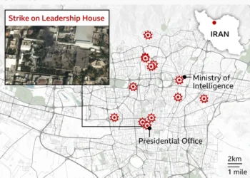
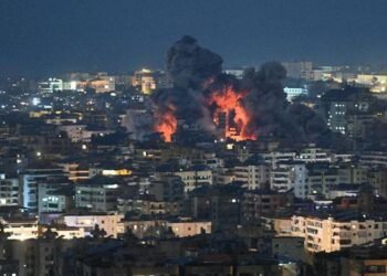
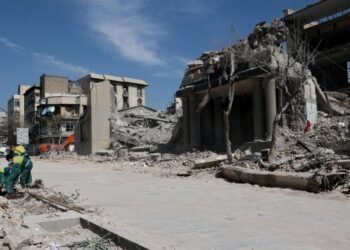
Newly released satellite imagery has provided one of the clearest visual records yet of the extensive damage inflicted on Iranian military infrastructure and nuclear complexes following coordinated US and Israeli airstrikes in recent days, highlighting the widening military conflict in the Middle East. Intelligence analysts and imaging firms have shared before‑and‑after photos showing strikes on naval bases, warships and facilities connected to Iran’s nuclear programme, illustrating the growing intensity of the offensive.

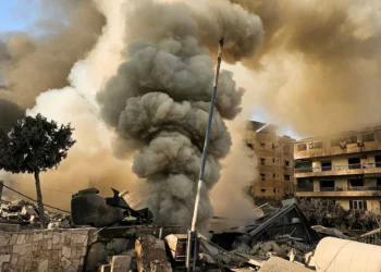
The satellite images from companies such as Planet Labs and Vantor — independently reviewed by analysts — show warships burning and damaged at Iran’s Konarak naval base on the Gulf of Oman, with plumes of smoke visible rising from the port area near Bandar Abbas where Iranian naval headquarters are located. Several vessels, including major frigates and support ships, appear to have been hit or sunk in the strikes, underscoring the focus on degrading Iran’s maritime capabilities.
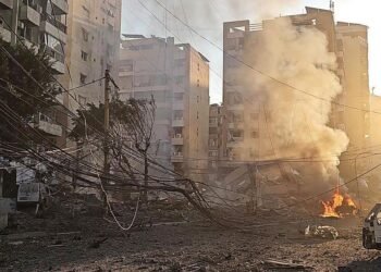
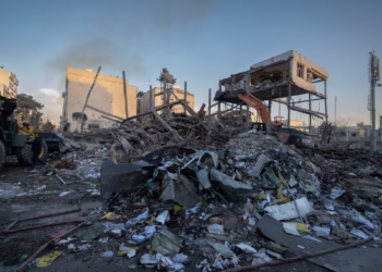
Imagery also reveals destroyed buildings, collapsed structures and scorched terrain at key military installations across Iran. At the Konarak Naval Base, aircraft shelters, tarmac and support facilities show visible breaches and damage consistent with precision strikes, while nearby infrastructure such as radar arrays and airfield installations has also been hit.
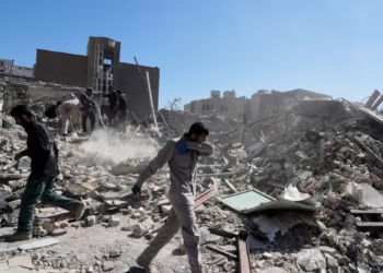
In addition to naval targets, the satellite data appears to show damage at the Natanz nuclear complex, a site long associated with Iran’s uranium enrichment activities. High‑resolution before‑and‑after photos capture destruction to outer buildings and access points that support deeper underground enrichment halls; independent experts caution that while the core underground facilities may not be directly penetrated, the visible damage could hamper logistical operations.
The imagery further documents damage at drone bases and missile-related infrastructure in western Iran, including collapsed tunnel entrances at the Tabriz North Missile Base, indicating that substantial underground and surface facilities have been compromised by recent attacks. Analysts note that these visual records offer a stark illustration of the scale of the offensive beyond traditional battlefield reports.
Officials in Washington and Tel Aviv have publicly acknowledged a broad campaign targeting scores of military and strategic locations in Iran, aimed at reducing the country’s capacity to launch missile, drone and naval operations. Iranian authorities have condemned the strikes as violations of sovereignty and warned of further retaliation, contributing to an increasingly volatile regional situation.

Experts say that while satellite imagery cannot independently verify the identity of the attackers or every specific strike, the photos provide unmistakable evidence of widespread destruction at Iranian military and nuclear‑linked sites. As the conflict evolves, continued monitoring from space forms a critical part of international efforts to document and analyse developments in near‑real time.
Related News:
 Bill Gates Pulls Out of India’s AI Summit Over Epstein Files Controversy
 Zuckerberg Defends Meta in Landmark Social Media Addiction Trial
 Russian Troops Executed by Commanders, Soldiers Tell BBC
 US Submarine Sinks Iranian Warship in Indian Ocean, Hegseth Says
 British AI Startup Outshines Human Forecasters in Global Prediction Contest
 UK Fighter Jet Purchase Could Breach Nuclear Treaty, Warns CND
 Google at 27: The Untold Story of Ruth Kedar, the Woman Behind the Iconic Logo
 Russia repeatedly targets UK military satellites, warns Space Command chief
 Cooper Unveils £4m Cyber Plan Against Russian Hackers
 Experts Warn Russia’s Burevestnik Missile Could Destabilise Arms Control
 Britain deploys RAF specialists to assist Belgium with drone threats
 Hitler’s DNA Confirms He Truly Had Only One Testicle
 Pokémon to open world’s first theme park in Japan next year
 Poll Reveals China Leads World in Trusting AI Technology
 US Clears Nvidia AI Chip Sales to China in Policy Shift
 Iran Signals Permanent Break From Global Internet, Activists Warn
 UK New Car Discounts Near £6,000 as Prices Are Slashed
 Musk Wants City on the Moon Within 10 Years
 Indian University Kicked Out of AI Summit for Claiming Chinese Robot Dog as Its Own Invention
 China Shows Off Nunchuck‑Wielding Humanoid Robots for Lunar New Year
 The Chinese AI App Sending Hollywood Into a Panic
 How Do You Modernise Mango Farming? India’s Growers Urged to Innovate as Climate Change Hits
 Billionaire Les Wexner Tells US Lawmakers He Was ‘Naive’ and ‘Conned’ by Epstein
 Etsy Sells Second‑Hand Fashion App Depop to eBay for $1.2bn
 Trump Vows UFO File Release After Obama Interview
 Musk Cuts Starlink Access for Russian Forces – Giving Ukraine an Edge at the Front
 Ukraine Negotiator Reveals What It Feels Like Facing Russia
 Mandelson Arrested Amid Political Turmoil as Ukraine Marks Four Years of Conflict
 Inside Kyiv’s resolve as conflict nears five‑year mark
 Ukraine war briefing: Why Ukraine remains defiant and does not feel close to defeat
 ‘Anyone who runs is shot’: Russian soldiers describe killings of troops who refuse orders
 Ukraine remembers its dead as war enters a fifth year
 ‘Fear Is Everywhere’: Reports From Mexican City Turned Into War Zone by Drug Cartel Feud
 Orbán Accuses Ukraine of Disrupting Oil Supplies to Hungary
 Social Media Trial: Woman Says Addiction Began at Six
Instagram Investigating AI Profiles ‘Fetishising’ Disabled People
Social Media Trial: Woman Says Addiction Began at Six
Instagram Investigating AI Profiles ‘Fetishising’ Disabled People
 Anthropic Boss Rejects Pentagon Demand to Drop AI Safeguards
 Epstein Tried to Buy a Palace in Morocco Days Before His 2019 Arrest
 Iran’s Regime Still Intact — Coming Days Will Test Its Survival
 Allies of US in the Gulf Bear Brunt of Iran Attacks
 Hopes and Fears as US Iranians Take to Streets After Toppling of Supreme Leader
 Retaliations Continue on Day Two of US-Israel Attacks on Iran
 At Least 153 Dead After Reported Strike on School, Iran Says
 Iran, the US, and a World Cup That Starts in Three Months
 Allies of US in the Gulf Bear Brunt of Iran Attacks
 Israeli Attacks Kill 31 in Lebanon, Iran Strikes Across Region, US Warplanes Crash in Kuwait
 In Maps: Strikes Across Iran and the Middle East
 Months of Planning Behind US‑Israeli Mission to Target Iran’s Supreme Leader
 UK Will Allow US to Use Bases to Strike Iranian Missile Sites, PM Says
 Why Russia Controls Its People With a Flick of a Switch
 Cooper: Joining US Strikes on Iran ‘Not in Britain’s Interest’
 What Khamenei’s Death Means for Russia and China
 Tehran Makes New Threat to Gulf Shipping as US Says ‘Hardest Hits’ on Iran ‘Yet to Come’
 Trump’s Iran Endgame Unclear After Mixed Messaging on War Aims
 Did Trump Declare War and Did Congress Approve Iran Attacks? What to Know
 Rubio Responds to Reported Strike on Iranian School
 The Third Day of the US‑Israeli War With Iran
 Why the US and Israel attacked Iran
 Israel Launches Fresh Strikes on Tehran & Beirut; US Warns “Hardest Hits” Ahead
 Three Days In, This War’s End Is Still Unclear
 US Has ‘Enough Weapons for Forever War,’ Trump Says
 At Least 169 Killed in South Sudan ‘Surprise’ Attack
 Israel Strikes Lebanon After Hezbollah Rocket Fire as Iran Conflict Widens
 Amazon Says Drones Damaged Three Facilities in UAE and Bahrain
 Man Recalls ‘Terrifying’ Dubai Missile Ordeal During Iran Strikes
 Israel’s New Airstrikes on Tehran & Beirut After US Embassy in Riyadh Is Hit
 Israel Launches Ground Invasion of Lebanon Amid Widening Middle East War
 The US Now Has the Medicine for Cheap Swarming Drone Attacks
 Iranian Rockets Are Testing the Resolve of Dubai’s Instagram Stars
 Boy George Says He’s Using ChatGPT to Help Write New Songs
 US Embassy in Riyadh Hit by Iranian Drones as Israeli Troops Enter Southern Lebanon
 US Strikes on Iran Triggered by Israel’s Plan to Launch Attack, Rubio Says
 Civilian Deaths in Iran Pass 700 Amid Fear of Bombs and Regime Clampdown
 US Senate Backs Trump War Powers Amid Iran Missile Barrage
 Russia Blames Ukrainian Naval Drones as Tanker Sinks
 Nepal Holds First General Election Since Gen Z Protests Toppled Government
 UK Government’s First Repatriation Flight to Leave Middle East, More Planned
 Why Aren’t Our Dirtiest Roads Getting Cleaned?
 Global Order Is ‘Breaking Down’, Carney Tells Australian Parliament
 Spain’s Sánchez Hits Back at Trump Threat to Sever Trade, Says ‘No to War’


