
Published: 08 April 2026. The English Chronicle Desk. The English Chronicle Online.
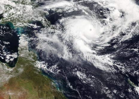
Severe Tropical Cyclone Maila has reached a terrifying level of intensity over the Solomon Sea. This massive storm system now ranks as a category five cyclone during this active season. Experts believe it will become one of the strongest storms to hit Australia this year. The Bureau of Meteorology is watching the system closely as it approaches the northern coast. Residents in far north Queensland are preparing for another major impact in very short order. This news comes only weeks after the region was battered by Severe Tropical Cyclone Narelle. Narelle made landfall on 20 March as a powerful and destructive category four weather system. Now the local communities must face an even stronger threat from the open tropical waters. Maila was located over the Solomon Sea on Wednesday while gathering more dangerous kinetic energy. Forecasters expect the storm to make landfall along the Cape York peninsula early next week. This timeline gives emergency services only a few days to prepare the local coastal towns.
Senior meteorologists are describing the current atmospheric conditions as extremely volatile for the southern hemisphere. Ilana Cherny noted that another major storm system is also developing further to the east. Severe Tropical Cyclone Vaianu is expected to hit New Zealand at the same time. This rare double threat across the Tasman Sea has put multiple nations on high alert. Maila has recorded a minimum central pressure of 924hPa which indicates a very powerful core. This measurement is significantly lower than the 930hPa pressure recorded during the peak of Narelle. Lower pressure readings generally suggest a much greater storm intensity and higher potential for damage. Cherny stated the storm would likely start to weaken as it moves toward the mainland. There is still a range of possibilities regarding the exact speed of the weather system. The system will likely cross the coast on Monday if current tracking models remain accurate.

The path of the storm appears to follow a trajectory very similar to Cyclone Narelle. Experts predict the cyclone will hit the coast between the Lockhart River and Cairns region. This specific area remains a significant watch point for authorities over the next few days. Queensland communities could start to see the first impacts from the weekend onwards throughout Saturday. These impacts include heavy rain and a high risk of flooding in many saturated catchments. Strong winds and hazardous surf conditions are also expected to develop along the eastern beaches. There is still some uncertainty about the exact strength of the cyclone upon its arrival. Maila looks like it will move very close to the southernmost islands of PNG. The interaction with land could disrupt the core of the storm before it reaches Australia. The effects of the cyclone were already being felt in the Solomon Islands on Wednesday.
Social media images show the destruction of property in remote parts of the Western province. Choiseul province has also reported significant damage to local infrastructure and many residential homes. Maila is the seventh storm to reach severe tropical cyclone strength during this current season. An Australian cyclone season typically runs from November through the end of April each year. Data since 1980 shows that only three or four cyclones usually make landfall annually. Only about five storms reach severe intensity in a standard year for the Australian region. Maila is likely to be the seventh tropical cyclone to make landfall this busy season. It will also be the third storm to cross the Queensland coast in recent months. Tropical Cyclone Koji was downgraded to a low just prior to hitting in January. Last month Narelle became the first system to hit three different states and territories.
Looking further east across the Pacific Ocean, the situation remains equally tense for other nations. Severe Tropical Cyclone Vaianu was classified as a category three system on Wednesday morning. It was located about 400km south-west of Nadi in the beautiful islands of Fiji. The system will likely weaken as it moves out of the warm tropical waters. It is expected to transition into an extra-tropical cyclone as it moves further south. The storm will track south-southwest towards New Zealand during the coming weekend for residents there. Most tracking models show the system crashing into the North Island with significant force. The New Zealand MetService has issued warnings of damaging and potentially life-threatening wind speeds. Professor Liz Ritchie-Tyo from Monash University has studied the formation of these two storms. Both Maila and Narelle formed relatively close to the equator during this warm period.
A specific circulation pattern has been steering these storms directly toward the western coastlines. Global heating is expected to make cyclones less frequent but significantly more intense over time. Preliminary observations suggest that modern cyclones seem to be moving a bit slower than before. When they make landfall the effects are felt for a much longer period of time. These storms also weaken more slowly once they have moved over the dry land mass. Adaptation becomes a really important factor for coastal communities facing these changing weather patterns. It might not just be about the most intense wind speed recorded during the peak. We must consider how long those strong winds stay active as they move inland. Many areas have not prepared or adapted for these kinds of prolonged extreme weather conditions. The duration of a storm can be just as damaging as its peak gust speed.
Emergency kits are being restocked across northern Queensland as the weekend approach draws near. Local officials are urging people to clear their properties of any loose or flying debris. The memory of Narelle is still fresh in the minds of those living in Cairns. Many homes are still undergoing repairs from the wind damage caused only three weeks ago. Now they face a category five system that could bring even more intense rainfall totals. Disaster response teams are being positioned in key areas to ensure a rapid reaction time. The state government has pledged full support for the region during this double weather event. Satellite imagery shows a very well-defined eye in the center of Cyclone Maila tonight. This visual evidence confirms the immense power contained within the swirling clouds and heavy rain. Ships in the Solomon Sea have been advised to seek safe harbor immediately to avoid.

The economic impact of consecutive storms is a growing concern for the local agricultural industry. Many crops were destroyed during the previous month and new plantings are now at risk. Farmers are working around the clock to secure equipment and protect what remains of their livelihoods. The tourism sector in far north Queensland is also bracing for a period of disruption. Flights to and from regional airports may be cancelled if the weather conditions continue to deteriorate. Travelers are being advised to check their itineraries and stay informed through official news channels. The resilience of the Australian people is being tested by this unprecedented string of cyclones. However, the sense of community spirit remains strong as neighbors help each other prepare for. Meteorologists will continue to provide updates every few hours as the storm gets much closer. The situation remains fluid and residents must stay vigilant until the danger has fully passed.
As Maila approaches the Cape York peninsula the sea state is expected to become mountainous. Large swells will likely cause significant coastal erosion along the sandy beaches of the north. This could impact local habitats and coastal infrastructure that was already weakened by previous tides. The combination of a high tide and a storm surge is a major worry. Such a surge can push seawater far inland and cause devastating floods in low areas. Local councils have started distributing sandbags to residents in the most vulnerable flood-prone zones. Power companies are also on standby to repair lines that might be downed by falling. Communication is vital during these times and radio stations will broadcast emergency alerts throughout the. Everyone is encouraged to have a battery-powered radio ready in case of power outages. The next forty-eight hours will be critical in determining the final path of Maila. We hope for the best but must prepare for the worst possible outcome tonight.
Related News:
 Dutch Nationwide Fireworks Ban Expected to Transform New Year Traditions
 Queensland Braces for Potential Second Severe Cyclone Hit
 Tragic End to Outback Search as Floods Claim a Life
 US Waste Crisis: Mexico Branded a Toxic Garbage Sink
 ‘Extinct’ Antelope Returns to Sahara, Bringing Hope
 Eden Project Founder Celebrates 25 Years of Nature’s Hope
 Capitol Attack Anniversary Sparks Deep Political Divide
 Saudi Officials Report Zubaidi Flee Before Yemen Peace Talks
 UK Targets in New York Bomb Threat Hoax: Man Jailed
 Gambia Supreme Court Hears Case to Overturn FGM Ban
 Storm Goretti leaves Cornwall homes without power
 Trump targets Iran trade with 25% tariff warning
 Rudd successor: Defence chief and former ministers considered
 US Senate rejects resolution limiting Trump military powers
 Venezuela regime claims release of political prisoners signals new era
 Gulf states warn Trump Iran strikes risk wider Middle East war
 Machado Trump medal gesture reshapes Venezuela power struggle
 Greenland defence seen as shared Nato duty amid troop arrivals
 Geopolitical football: Iran, Trump and the World Cup clash
 Canada-China trade gains momentum in new strategic partnership
 Trump Receives Machado’s Nobel Medal in White House Meeting
 Syria President Declares Victory as Ceasefire Reached with SDF
 US Considers Asylum for British Jews Amid Rising Antisemitism
 Trump slams UK ‘stupidity’ over Chagos Islands, eyes Greenland takeover
 No Gas Boiler Ban as UK Warm Homes Plan Backs Heat Pumps
 Trump Tightens Grip on EU and UK Energy Supply
 Shinzo Abe’s killer receives life sentence in Japan
 Record-Breaking Heat Looms Over South-East Australia as Catastrophic Fire Risk Escalates
 UK joins North Sea wind grid pact with nine European nations
 China General Under Investigation Amid Leadership Purge
 Philippines ferry disaster leaves 15 dead, dozens missing
 Devon hosts first high-density hydro power system
 US-Style Pickup Trucks Surge on UK Roads
 Cambridge Faces Scrutiny Over Arms Investment Transparency
 James Valentine Retires from ABC After Cancer Battle
 Wigan Dump Crisis Sparks Health and Safety Alarm
 Epstein UAE Emails Shake British Royal Andrew’s Legacy
 Christchurch gunman seeks to vacate guilty plea
 Liberal Fallout: Taylor Challenge Casts Shadow Over Sussan Ley’s Leadership
 Infantino Faces Russia Threat and Trump Concerns at Uefa Congress
 Concerns rise for Canberra boy amid Iran detention fears
 Gentoo Penguins First Birds on Australian Territory Hit by Bird Flu
 Caribbean Leaders Urge Dialogue Amid US Oil Embargo on Cuba
 Germany Faces Backlash Over Scrapped Renewable Heating Mandate
 Group Expands Legal Claim Over South West Water Pollution
 Greenpeace $345m Ruling Sparks Appeal Battle
 Ukraine Sends Drone Experts to Defend US Bases in Jordan
 New Zealand Covid Response Praised Despite Lingering Scars
 Abramovich Chelsea Sale Cash Faces Jersey Probe
 London Considers New SUV Charges to Improve Road Safety
 Yvette Cooper: UK Must Follow Principles, Not US Pressure
 US Strike on IRIS Dena Strains Strategic Indian Security Ties
 Slovenia Election: A Nation at a Crossroads
 MPs Slam Agency Over Failing Fight Against Waste Dumping
 Jury Rules Meta and YouTube Liable for Addictive Design
 Saudi Arabia Urging US to Keep Up Iran Attacks
 Trump Softens Cuba Oil Stance as Russian Tanker Nears
 The Woman Guarding Earth From the Threat of Asteroids
 IMF Predicts Global Economic Crisis Due to Gulf Unrest
 California Defies Trump With Strict New AI Standards
 Germany Grapples With AI Abuse Following TV Star Scandal
 Exiled Tycoon Warns of New Russian Attacks on UK Soil
 Labor Under Fire Over Stalled University Fee Reform
 LA 2028: Millions of Affordable Olympic Tickets Announced
 Trump Slams Europe as Transatlantic Tensions Boil Over
 Inside the Deceptive Machine: A Former Producer Speaks Out
 Italy Faces Third Successive World Cup Absence After Loss
 Starmer Urges Ambitious EU Ties Amid Middle East Conflict
 Spain Faces Backlash Over Xenophobic Chants in Egypt Draw
 A Global Voice For Justice: Stephen Lewis Dies At Age 88
 Trump Issues Stark Warning After Strike On Iran’s Largest Bridge
 Hope and Fear as Iranians Flee Across the Turkish Border
 Evacuations Ordered as California Wildfires Spread Fast
 Ben Roberts-Smith Arrested Over Alleged War Crimes
 Reform UK Pledges To Halt Visas Over Reparations Demands
 US and Iran Agree to Two-Week Provisional Ceasefire
 Starmer visits Gulf as US and Iran agree ceasefire
 Gaza Child Arrives in UK for Life-Changing Care
 UK Fossil Fuel Expansion Risks Global Climate Collapse
 Israel Defies Ceasefire as Lebanon Operations Persist