
Published: 24 August 2026 | The English Chronicle Desk | The English Chronicle Online
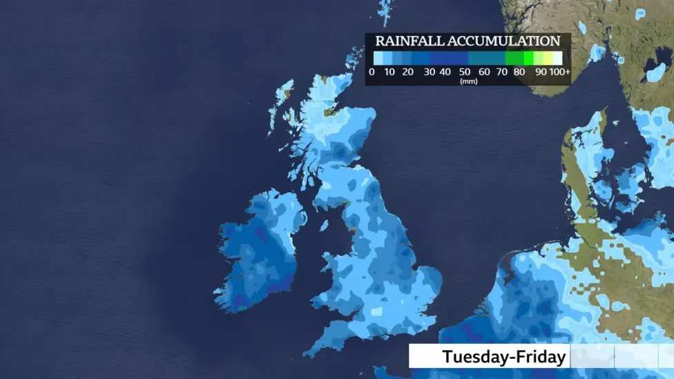
After a prolonged spell of dry and, in some areas, exceptionally warm weather, rain is set to return to parts of the UK this week, bringing the possibility of thunderstorms, torrential downpours and localised flooding.
The change in weather will be welcomed in regions struggling with drought and depleted water supplies, but forecasters warn that a few days of rainfall will not be enough to reverse the effects of a prolonged period of dry conditions.
Some areas could see showers from Tuesday, while more widespread rain is expected from Wednesday as low pressure moves in from the south-west. The unsettled spell could continue through Friday, with southern England and Wales facing the greatest risk of heavy and potentially thundery rainfall.
At the same time, warmer air moving north from southern Europe could push temperatures towards 27C (81F) in parts of England and Wales, creating an unusual combination of warmth, humidity and heavy rain.

Rain arrives as the weather turns unsettled
Monday is expected to remain largely dry, with sunny spells across much of the country. However, the weather pattern will begin to change on Tuesday as low pressure approaches from the south-west.
Showery conditions are expected to develop across parts of southern England and south Wales, marking the beginning of a wetter period.
By Wednesday, rainfall is forecast to become more widespread across England, Wales and Northern Ireland. Scotland is likely to remain drier in many areas, although conditions could change as the weather system develops.
Some of the showers may be heavy, with thunderstorms possible in places.
The greatest concern comes later in the week, when the combination of warm air and increased atmospheric moisture could produce intense downpours.
From Wednesday evening through Friday, there is a heightened possibility of torrential rain, hail and thunderstorms, particularly across southern England and Wales.
Heavy rainfall falling over a short period can overwhelm drainage systems, streams and smaller rivers, creating localised flooding even when wider rainfall totals are not exceptionally high.
Why flooding could become a concern
The return of rain might appear entirely positive after weeks of dry weather, but the way rainfall arrives is important.
Much of the ground in affected areas has become unusually dry and hard. When intense rain falls on compacted or baked soil, water may initially run across the surface rather than soaking efficiently into the ground.
This can increase the risk of surface-water flooding, particularly in urban areas and locations close to steep slopes, streams and drainage channels.
Thunderstorms can make the situation more difficult because they often produce very intense rainfall over relatively small areas.
One town may receive little rain while another nearby location experiences a sudden downpour capable of causing flooding within a short period.
The risk is therefore expected to be localised rather than uniform across the country.
For communities that have experienced drought conditions, the arrival of rain also presents a complicated picture. While rainfall can improve soil moisture and river flows, sudden heavy rainfall is not necessarily the most effective way to replenish deeper water stores.
Rain will help, but drought will not end quickly
The wet weather will provide some relief to parts of the UK that have experienced prolonged dry conditions.
Rain can gradually increase soil moisture, support vegetation and improve river levels. It can also provide some additional water to reservoirs and other surface-water supplies.
But experts stress that drought recovery takes considerably longer than a single spell of rainfall.
The British Geological Survey has previously explained that significant cumulative rainfall over an extended period is required before drought conditions can fully ease.
A drought is not officially over simply because rain has returned. Soil moisture, rivers, groundwater and reservoirs all need to recover to levels considered normal for the time of year.
The UK’s groundwater systems have nevertheless shown some resilience during the current period of dry weather.
The British Geological Survey recently reported that, among 35 groundwater monitoring sites surveyed around the UK, only eight were showing notably low levels.
That suggests the situation underground is not uniformly severe, even though some areas are experiencing significant water stress.
Rainfall during the coming week could therefore be useful, but the benefits will depend on how much rain falls, where it falls and whether further dry weather follows.
Warm air could push temperatures towards 27C
The unsettled conditions will not necessarily mean a return to cool weather.
Instead, warmer air moving north from southern Europe is expected to push temperatures upwards during the middle of the week.
Scotland and Northern Ireland could see temperatures around 21C by Wednesday, while parts of southern England and Wales could approach 27C.
The south-east of England is expected to experience some of the highest temperatures.
The combination of warmth and moisture could contribute to the development of heavy showers and thunderstorms.
However, the warmer spell is expected to be relatively short-lived. Current indications suggest temperatures are unlikely to reach heatwave thresholds again before the end of August.
This would represent a marked change from the more persistent periods of hot and dry weather experienced earlier in the summer.
What happens after the unsettled spell?
Beyond Friday, the forecast becomes less certain.
Weather models are currently suggesting that higher pressure could begin to build towards the second week of September. If that pattern develops, it could once again encourage warmer air to move towards the UK.
Southern England is expected to have the greatest potential for higher temperatures under such a pattern.
Long-range forecasts remain subject to considerable uncertainty, however, and changes in atmospheric circulation can alter the UK’s weather considerably from one week to the next.
For now, the immediate focus is on the transition from dry conditions to a wetter and more unstable pattern.
The contrast could be particularly striking in areas that have recently experienced water restrictions or drought concerns.
A complicated end to the summer
The return of rain highlights the difficulty of interpreting the UK’s increasingly variable summer weather.
For people affected by dry conditions, rainfall will be welcomed. Farmers, gardeners and water managers will benefit from improved soil moisture, while rivers and reservoirs could gradually begin to recover.
But the possibility of intense thunderstorms means the rain will also bring hazards.
The risk of flooding is particularly relevant because the ground in some areas has become less capable of absorbing large amounts of water quickly. Heavy downpours could therefore cause disruption even while the wider country remains short of the rainfall required to fully recover from drought.
The situation illustrates why rainfall totals alone cannot determine whether water shortages have been resolved.
A sustained period of moderate rainfall may ultimately be more beneficial for groundwater and reservoirs than a handful of intense thunderstorms.

For residents in southern England and Wales, the coming days could therefore bring rapidly changing conditions, from warm sunshine to sudden downpours and thunderstorms.
People travelling, walking or taking part in outdoor activities may need to remain alert to local weather developments, particularly when thunderstorms are forecast.
The immediate forecast points towards a wetter and more unsettled period, but the longer-term picture remains uncertain.
Rain will return, temperatures will rise again and thunderstorms could develop. Yet despite the prospect of significant rainfall in some areas, experts caution that the UK’s drought conditions will require much more than a few wet days to disappear.
For now, the country faces a distinctly mixed weather pattern: welcome rain for parched landscapes, potential disruption from intense storms and another brief spell of summer warmth before the next shift in the UK’s weather.
Related News:
 Storm Dave Disrupts Travel but Conditions Set to Ease
 UK Must Act with Courage and Clarity on Israel-Palestine Conflict, Says Foreign Affairs Committee Report
 London Set to Honour Euro 2025 Champions as Lionesses Take Victory Parade Through the Capital
 Targeted Attack in Bury Sparks Murder Investigation as Community Awaits Justice
 Princess of Wales Launches Animated Video Series to Support Early Childhood Development
 Heartbreak in the New Forest as Shetland Ponies Vanish, Community on Edge
 Fire Contained at Edinburgh’s Arthur’s Seat After Overnight Battle by Firefighters
 Premier League Supercomputer Predicts Tough Season for Man Utd Amid Three-Team Title Battle
 UK Weather: Heat Alerts Extended as Temperatures Set to Reach 30°C This Weekend
 Merseyside Police Helicopter Crew Cleared After Low-Altitude Pursuit of Suspect
 Education Leaders Call for End to Compulsory GCSE Resits in English and Maths
 Thousands of New School Nursery Places to Be Rolled Out Across England
 Tanni Grey-Thompson Faces Abuse Over Opposition to Assisted Dying Bill
 Birmingham Bin Strike Enters Sixth Month as Negotiations Stall
 Over 40% of Private Renters Forced to Ration Energy to Afford Bills, Study Reveals
 Systemic Racism in Maternity Care Continues to Endanger Black Women in England, MPs Warn
 Northern Ireland Faces Fears of Prolonged Race Riot “Permacrisis”
 Nigel Farage Unveils Controversial Immigration and Welfare Plans at Reform UK Press Conference
 Scottish Teenager’s Petition on Single-Use Plastics Gains Parliamentary Support
 White Low-Income Pupils in England Show Lowest Levels of School Engagement, Study Finds
 No Evidence Found to Substantiate Alleged Rape in Oxfordshire Churchyard, Police Confirm
 UK House Price Growth Slows as Buyers Exercise Caution Ahead of Autumn Budget
 Massive London Poundland Fire Engulfs High Street
 Paedophile Singer Ian Watkins Dies After Prison Attack
 UK border officers deployed to Balkans to tackle migrant smuggling
 UK MPs warn of repeat riots over online misinformation
 Kate Winslet to Narrate Film Highlighting King’s Environmental Mission
 Trump’s UK Ambassador Urges North Sea Drilling to Strengthen US Ties
 UK Bans Fake Numbers: Scammers Lose Their Trick
 Millionaires group urge Reeves to introduce wealth tax to ‘lift kids out of poverty’
 Reeves rejects £1bn plea for NHS redundancy payouts
 PM Condemns Leaks, Vows Loyalty to Ministers and Stability
 Inside the Helpline Protecting Missing Children in the UK
 PlayStation PS5 Deals Hit Lowest Prices Ahead of Black Friday
 Five-Year-Old Dies After Rare Tonsil Surgery Complication
 Starmer Says Labour’s Economic Plan Needs Years to Deliver
 Historic £100-Weekly Pension Boost Brings Relief for UK Mineworkers
 Starmer Faces Parliamentary Battles Over UK-EU ‘Reset’ Plan
 Met Police Vetting Failures Let Serial Rapists Remain
 Fatal Bolton Taxi Crash Claims Three Teens and Driver
 ScottishPower Tops List of Worst UK Energy Suppliers
 Judi Dench Champions Fight to Save London’s Green Spaces
 Crowborough Camp Welcomes First Asylum Seekers
 BBC Funding Crisis: Tim Davie Warns of Jeopardy Ahead
 Artificial intelligence will cost jobs, admits Liz Kendall
 Older Women Vanish from BBC Screens, Review Confirms Bias
 Streeting moves on doctor pay to end strike dispute
 Send spending gap leaves deprived areas behind
 Hidden Crisis: Domestic Abuse Suicide Toll in UK
 UK Unemployment Rate Climbs to 5.2% Peak
 BBC World Cup Presenting Duties Shared Among Trio
 Wales Approves Assisted Dying Bill Consent
 CPS Updates Guidance on Honour-Based and Dowry Abuse
 Asylum Seekers to Work After Year-Long Wait
 Inquiry into HMRC child benefit errors launched by NAO
 Rising Costs Force Families to Rethink Days Out
 Scott Mills Sacked by BBC Over Personal Conduct Claims
 Palantir Boss Defends NHS Deal Amid Government Break Clause
 Relationship with Trump may be beyond repair, Starmer warned
 UK Government Poised to Revive Stalled Hillsborough Law
 Blue Badge Abuse: The Rising Tide of Public Hostility
 Scott Parker Leaves Burnley After Premier League Drop
 Silent Tracks: Rail Line Without Passengers
 RFU Backs Borthwick Despite England’s Poor Six Nations
 Major test for Labour as polls open in Great Britain
 Keir Starmer Struggles to Secure His Grip on Downing Street
 Farage Faces Standards Probe Over Cash Property Purchase
 Closing the Gap: UK Pensions Commission Demands Action
 Russian Electronic Attack Targets UK Defence Chief Jet
 UK Shoppers Face Prolonged Price Rises At Tills
 Tube Strike Brings Capital to a Standstill Over Shift Disputes
 Makerfield Voters Demand Real Change as Election Looms
 Ryanair Faces Probe Over Mandatory Family Seating Fees
 Britain’s Crowning Butterfly Takes the Nation by Storm
 Stirchley Community Housing Scheme Faces Crisis
 Watchdog Warns Ministers to Pause Impending HS2 Reset
 EU Slashes Steel Quotas But Grants UK Favourable Rates
 Welfare System Faces Radical Overhaul After Timms Review
 Burnham Pledges New Era of Open Debate for Labour MPs
 Unions Warn Labour Over Zero-Hours Contract Reforms