

Published: 12 November 2025 | The English Chronicle Desk | The English Chronicle Online
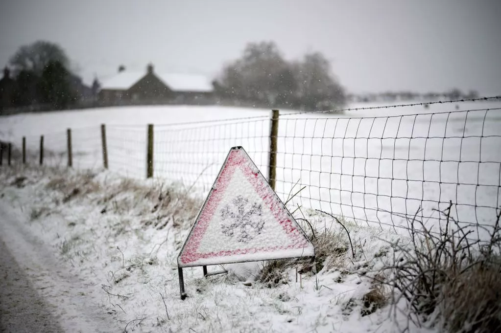
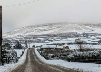
The UK is bracing for a significant cold snap, with temperatures expected to drop to lows of -7C, as icy winds and heavy snowfall sweep across much of the country. Meteorologists attribute the plunge in temperatures to a major disruption of the Polar Vortex caused by an unusually early Sudden Stratospheric Warming (SSW) event.
The Polar Vortex, a large area of low pressure and cold air surrounding the Earth’s poles, plays a crucial role in regulating winter weather across the Northern Hemisphere. When this vortex is disrupted, Arctic air can spill southward, leading to sudden cold spells and heavy snowfall in regions that are typically milder at this time of year.
For most of November, the UK has experienced unsettled conditions, with frequent rain and relatively mild temperatures. However, as high pressure builds over the North Atlantic and the Arctic air mass pushes south, forecasters predict a dramatic shift. Snowfall is likely to affect much of the country, with the heaviest accumulations expected in northern England, Scotland, and parts of Wales. Icy conditions will pose challenges for commuters, particularly on untreated roads and rural routes.

Experts warn that temperatures will remain well below seasonal averages over the weekend and into the second half of November. “This is a classic example of how sudden stratospheric warming can influence weather patterns in the UK,” says Dr. Eleanor Marks, a climate scientist at the Met Office. “We expect prolonged periods of frost and snow, which could have a serious impact on travel, infrastructure, and energy demand.”
Authorities are advising the public to prepare for hazardous conditions, especially those traveling for work or leisure. Schools and local councils may implement contingency plans, including snow clearance and safety alerts, to ensure public safety during the extreme weather period.
The early arrival of this Arctic blast has implications beyond daily life, with energy consumption expected to rise as households heat homes and businesses brace for the cold. Experts note that prolonged exposure to such low temperatures could strain the energy supply network and increase the risk of frozen pipes and other winter-related damage.

In addition to the cold temperatures, forecasters are monitoring the potential for drifting snow and localized blizzards in higher-altitude areas. Drivers and pedestrians are urged to exercise caution, and those living in vulnerable areas should prepare for possible disruptions to transport and utilities.
While the Polar Vortex phenomenon is not unusual, the timing and intensity of this stratospheric warming event are considered early and significant for the UK. Scientists continue to study these events to improve long-range forecasting and better understand the complex interactions between Arctic atmospheric conditions and weather patterns further south.
Residents are encouraged to stay updated with local forecasts and follow guidance from the Met Office and local authorities. For those hoping for a winter spectacle, the snow may offer a picturesque scene, but officials emphasize that safety should remain a priority as the icy conditions take hold.
Related News:
 Delhi’s Toxic Air Crisis Leaves Children Sick and Vulnerable
 Delhi’s Toxic Air Drives Spike in Respiratory Illnesses
 UK Weather: Rain Expected Above Average This Autumn, but Drought Likely to Persist
 Prince William Plants Trees with Brazil’s Nature Heroes
 Nicola Sturgeon Urges SNP to Oppose New Oil Fields
 Jailed UK climate protesters face extremist-style restrictions
 Delhi Tightens Curbs as Citizens Protest Over Toxic Air
 New weather warning issued with risk of flooding
 Cold Snap Brings Snow Risk as Flood Recovery Continues
 Snow and Ice Warnings Affect Scotland and Northern England
 Thousands at Risk in Gaza Amid Winter Flooding
 Witnesses Recall Tragedy as Couple Die in Flood
 Commuters warned as yellow snow and ice alert hits Northern Ireland
 Arctic Blast Hits UK as Snow and Ice Warnings Trigger Travel Disruption
 West Councils Falling Behind on Climate Goals
 Africa Demands Climate Justice Linked to Colonial Past
 Snow and Ice Cause Travel Chaos in North Yorkshire
 Turkey to Host COP31 After Breakthrough Deal with Australia
 UK Energy Bills to Rise Slightly in January
 Australia Launches Major Environmental Law Reforms
 Sri Lanka Floods Leave 56 Dead, Dozens Missing
 Families wait in agony for missing after Hong Kong tower blaze
 Rare shark attack kills woman, injures man at remote NSW beach
 Southeast Asia floods claim 241 lives, rescue efforts continue
 Severe Thunderstorms Lash England and Scotland: Met Office Issues Amber and Yellow Warnings Amid Flooding Risks
 Britain’s Butterfly Numbers Rebound but Remain Average
 Scottish Teenager’s Petition on Single-Use Plastics Gains Parliamentary Support
 King urges faster action on climate change initiatives
 Peterborough Mosques Tighten Security After Attack
 Hospice Cuts Raise Alarm Across England Amid Funding Crisis
 UK Woman Loses Child Benefit After Booking Flight She Never Took
 UK launches search for first-ever ‘town of culture’ to highlight overlooked areas
 Army Officers Orders to Cut Ties with Men-Only Clubs
 Children to Learn Local History in Major Curriculum Overhaul
 Experts Warn on Home Birth Risks, Call for Skilled Midwives
 The Lowry Hotel: Manchester’s Iconic Five-Star Retreat
 World Whisky Tour: 9 Global Gems
 Greta Thunberg Backs Student Facing UK Visa Revocation
 Kent village told to remove flags before Christmas lights go up
 Earl of Yarmouth Faces £1.3m Legal Bill Over Family Estate
 Newcastle United Lifts Ban on Fan Over Gender-Critical Views
 How to get help when a child goes missing – call 999 urgently
 ‘Reckless’ cuts to victims’ services will cost more than they save
 From Lego to Pokémon: How Adults Are Driving UK Toy Market Growth
 Seven Conditions That Automatically Qualify You for a Free Bus Pass
 UK toy market enjoys bumper year as ‘kidults’ fuel demand
 Politics latest: Starmer ‘will fight any leadership coup’ as Streeting denies attempt to oust Labour PM
 Leading doctors issue warning amid ‘bad’ flu season
 Son Reveals UK Couple in Iran Resort to Hunger Strike for Help
 South Korea’s Jeju Island Faces Rising Tide of Illicit Drugs
 Working-Class Men with Prostate Cancer Left Behind by NHS
 Pat Butcher Returns to EastEnders in Touching Dementia Storyline
 Australia Mourns Paralympic Champion Paige Greco
 UK Asylum Overhaul Sparks Debate Over Human Rights and Deportations
 UK Asylum Reforms: Temporary Refugee Status and Faster Deportations
 Mum Calls for New Licence Rules After Teen Road Death
 Mother Watches in Horror as Teen Daughter Dies on Tracks
 Agency Workers Vote to Join Picket Lines Amid Dispute
 Irish Hero Parrott Says Goal Brought First Tears in Years
 107-Year-Old Veteran Credits Whiskey for Longevity
 Seven Countries, One Winner: Europe’s Best Christmas Market
 ‘Traumatic Wait’: Northern Ireland Women Face Breast Cancer Delays
 Healthy Habits in Your 30s That Boost Life in Your 70s
 Woman Meets Boy Whose Life She Saved with Kidney
 Vietnam Battles Deadly Floods as Rains Continue
 Raccoons Could Become America’s Next Pet
 Kate Forbes: Motherhood Harder Than Politics
 Coffins Now Too Large to Cremate Amid Rising Obesity Crisis
 Clifftop Lodges Spark Fears Over Jurassic Coast Stability
 Labour MP claims devolution bill is ‘blatant discrimination’ against Cornwall
 Vicki Fears Losing Motability Car
 Planned Palestinian Flag Raising at Belfast City Hall Faces Delay Amid Legal Concerns
 Residents Face £3.6m Bill for Unsafe Kirkby Flats
 Fibromyalgia Patients Struggle as NHS Fails to Provide Care
 Scotland Gains 33 New Towns – Life in Growing Communities
 Machynlleth High Street Left Without Christmas Lights
 A Colourful Cultural Escape in Mexico’s Querétaro
 Search underway for British man overboard off Tenerife
 Virgin Media Fined £23.8m Over Telecare Safety Failures
 Pavarotti statue frozen in Italian ice rink sparks backlash


