


The UK snow forecast Arctic blast has put the nation on high alert as forecasters warn of severe winter conditions developing across much of the country. According to the Met Office, the UK snow forecast Arctic blast will usher in heavy snowfall, freezing temperatures and gale-force northerly winds, with some areas at risk of seeing up to 11 inches of snow. As the UK snow forecast Arctic blast intensifies toward the New Year period, travel disruption, power outages and hazardous conditions are expected, particularly in northern and eastern regions.

Meteorologists say the cold spell will affect much of the country, with daytime temperatures expected to drop as low as minus four degrees Celsius in places. Night-time lows are likely to fall even further, increasing the risk of ice and making already hazardous travel conditions more dangerous. Snow showers are forecast to become increasingly widespread through Thursday and Friday, initially affecting higher ground before spreading to lower levels as the cold air deepens.
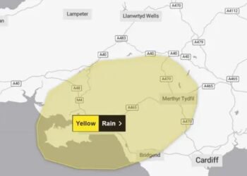
The Met Office has issued a weather warning for snow and ice covering New Year’s Day and Friday, highlighting the potential for significant accumulations, particularly across northern and eastern regions. Forecasters explain that showers will increasingly turn to snow as a strong, and in some places locally gale-force, northerly wind develops. While early snowfall is expected to be more limited to upland routes, accumulations are forecast to build rapidly by Thursday evening, even at low levels.
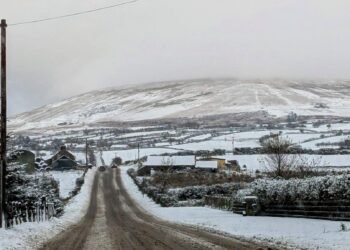
By Friday morning, many areas could see between two and five centimetres of lying snow, with isolated locations recording as much as ten centimetres. Above 200 metres, the risk is more severe, with ten to twenty centimetres of snow likely in some places. On the highest hills and exposed routes, accumulations of 30 centimetres or more are possible through the period. The Met Office has warned that the strength of the wind will lead to significant drifting, potentially blocking roads and cutting off rural communities.
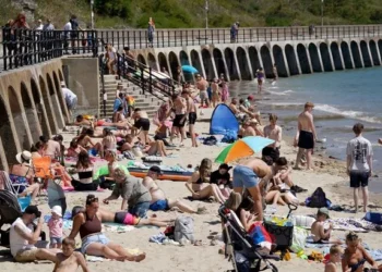
Scotland is expected to bear the brunt of the worst conditions, with heavy and persistent snow forecast across the Highlands and Aberdeenshire. Travel disruption is considered highly likely, particularly on major routes and rail lines serving the north of the country. With Hogmanay celebrations taking place, authorities are urging caution as weather conditions could disrupt events and pose safety risks for revellers.
Strong northerly winds will compound the hazards, especially along the east coast. Gusts of up to 60 miles per hour are expected around the North Sea coastline, including parts of Humberside, creating blizzard-like conditions in exposed areas. These winds are forecast to peak from New Year’s Day evening through Friday, making driving conditions treacherous and increasing the likelihood of delays and cancellations across road, rail and air networks.
While Scotland faces the heaviest snowfall, much of England and Wales will also experience wintry conditions. Snow showers are expected to reach as far south as Kent by Saturday, an unusual extent that underlines the severity of the cold air mass. Weather maps issued by Metdesk, an independent meteorological service, show snow spreading across large swathes of the country, with flurries possible across London during Saturday night.
In England, forecasters are particularly concerned about the East Midlands, including counties such as Lincolnshire and Leicestershire, where heavier snow is feared on Saturday evening. The snow is expected to move steadily east overnight, with Norfolk likely to see a dusting by Sunday morning. Although accumulations in southern areas may be lighter and more intermittent, even small amounts of snow could cause disruption given the strength of the winds and the likelihood of ice.
The Met Office has stressed that the cold, northerly flow will persist through at least the early part of the period, meaning conditions may remain unsettled and wintry for several days. Subtle shifts in wind direction will determine which areas are most exposed to snow showers on any given day, but where these showers occur, significant accumulations are possible. Coastal and eastern areas facing onshore winds are considered particularly vulnerable.
Despite the seriousness of the forecast, the Met Office has so far issued no additional weather warnings beyond those already in place for New Year’s Day and Friday. However, forecasters have cautioned that new alerts could be issued at short notice, especially for Saturday, as confidence grows in the extent and intensity of the snowfall. Members of the public are being advised to keep up to date with the latest forecasts and warnings as conditions evolve.

Travel disruption is a major concern, particularly as transport hubs are expected to be busy following New Year celebrations. Snow, ice and high winds can cause delays, cancellations and dangerous driving conditions, and authorities are urging people to plan ahead. The Met Office has advised motorists to check routes for delays and closures, allow extra time for journeys and amend travel plans if necessary.
Drivers are also being encouraged to prepare their vehicles before setting off, ensuring they are winter-ready and stocked with essential items in case of delays. Warm clothing, food, water, blankets and torches are among the items recommended, along with ice scrapers, de-icer and phone chargers. Officials also highlight the importance of being prepared for potential power cuts or temporary isolation, particularly in rural or upland areas where heavy snow and drifting could cut off access to services.
As the Arctic air mass tightens its grip on the UK, the coming days are set to provide a stark reminder of winter’s power. While snow can bring scenes of beauty, the Met Office is keen to emphasise the risks posed by severe winter weather and the importance of preparation. With the possibility of significant snowfall, strong winds and freezing temperatures coinciding with a busy travel period, vigilance and caution will be essential for communities across the country.
Related News:
 Storm Floris Sparks Amber Alert in Scotland Amid ‘Danger to Life’ Wind Forecast
 Storm Floris Batters Northern UK With Ferocious Winds and Disrupts Travel Nationwide
 Storm Floris Slams the UK,‘Danger to Life’ Warnings as Ferocious 90mph Winds Cause Chaos Nationwide
 A Delicate Dance of Sunshine and Storms: UK’s Summer Forecast Holds Mixed Fortunes for Holidaymakers
 Fire Contained at Edinburgh’s Arthur’s Seat After Overnight Battle by Firefighters
 England Braces for Prolonged Dry Spell as National Drought Group Urges Urgent Water-Saving Measures
 England Faces “Nationally Significant” Water Shortfall as Fourth Heatwave of 2025 Strikes
 UK Heatwave Continues with Temperatures Soaring, Thunderstorms Forecast Across the Country
 UK Weather: Heat Alerts Extended as Temperatures Set to Reach 30°C This Weekend
 K Braced for 600-Mile Rainstorm with Eight Counties Set to Escape Downpours
 UK Faces One of Its Warmest Summers on Record, Met Office Confirms
 UK Rocked by Two Earthquakes in Three Hours as Tremors Strike Cumbria and Iconic Welsh Landmark
 UK Weather: Rain Expected Above Average This Autumn, but Drought Likely to Persist
 Yellow Weather Warning Issued as UK Braces for Winds Up to 80mph
 Storm Amy set to disrupt travel across UK with winds reaching 95mph
Storm Amy Ravages UK: Fatalities, Widespread Travel Chaos, and Power Outages
Storm Amy Wreaks Havoc Across UK and Ireland, Claims One Life
Storm Amy set to disrupt travel across UK with winds reaching 95mph
Storm Amy Ravages UK: Fatalities, Widespread Travel Chaos, and Power Outages
Storm Amy Wreaks Havoc Across UK and Ireland, Claims One Life
 What is anticyclonic gloom and why is it making the weather?
 UK braces for wet weekend as Met Office issues NI rain warning
 Hermer to face questions on alleged China spy case intervention
 Storm Benjamin Set to Lash UK with Heavy Rain and Strong Winds
 Northern Lights May Illuminate UK Skies Amid Strong Solar Storm
 Northern Lights may illuminate UK skies this week
 New weather warning issued with risk of flooding
Storm Claudia: Torrential Rain to Batter England and Wales
New weather warning issued with risk of flooding
Storm Claudia: Torrential Rain to Batter England and Wales
 Cold Snap Brings Snow Risk as Flood Recovery Continues
 Witnesses Recall Tragedy as Couple Die in Flood
 Commuters warned as yellow snow and ice alert hits Northern Ireland
 UK Energy Bills to Rise Slightly in January
 “Enough is Enough”: Local MP Vows to Fight Rainham Quarry Plans
 ‘Extinct’ Antelope Returns to Sahara, Bringing Hope
 Man Escapes as Giant Hole Swallows Boats on Shropshire Canal
 Heat, Drought and Fire Push UK Nature to Breaking Point in 2025
 UK Must Act with Courage and Clarity on Israel-Palestine Conflict, Says Foreign Affairs Committee Report
 The Ketamine Crisis in the UK is a Silent Epidemic Leaving Users with Lifelong Pain
 London Set to Honour Euro 2025 Champions as Lionesses Take Victory Parade Through the Capital
 Targeted Attack in Bury Sparks Murder Investigation as Community Awaits Justice
 Princess of Wales Launches Animated Video Series to Support Early Childhood Development
 Heartbreak in the New Forest as Shetland Ponies Vanish, Community on Edge
 Radioactive Leak at UK’s Nuclear Warhead Base Sparks Outcry Over Safety and Secrecy
 Premier League Supercomputer Predicts Tough Season for Man Utd Amid Three-Team Title Battle
 Mystery Wallaby Spotted on Norfolk-Suffolk Border Sparks Police Appeal
 Terence Stamp, ’60s British Film Legend and Star of Superman, Dies at 87
 Merseyside Police Helicopter Crew Cleared After Low-Altitude Pursuit of Suspect
 Is the UK Ready to Put Boots on the Ground in Ukraine? Assessing Military Capacity and Challenges
 Education Leaders Call for End to Compulsory GCSE Resits in English and Maths
 Police Scotland Spends £500,000 Compensating Officers Over Trump Visit
 Massive 641-Mile Storm Set to Batter UK with 15 Hours of Rain and Strong Winds
 Thousands of New School Nursery Places to Be Rolled Out Across England
 Urgent Action Needed on Windrush Compensation as Survivors Speak of “Waiting to Die”
 Tanni Grey-Thompson Faces Abuse Over Opposition to Assisted Dying Bill
 Birmingham Bin Strike Enters Sixth Month as Negotiations Stall
 Over 40% of Private Renters Forced to Ration Energy to Afford Bills, Study Reveals
 Systemic Racism in Maternity Care Continues to Endanger Black Women in England, MPs Warn
 Northern Ireland Faces Fears of Prolonged Race Riot “Permacrisis”
 Nigel Farage Unveils Controversial Immigration and Welfare Plans at Reform UK Press Conference
 Scottish Teenager’s Petition on Single-Use Plastics Gains Parliamentary Support
 White Low-Income Pupils in England Show Lowest Levels of School Engagement, Study Finds
 No Evidence Found to Substantiate Alleged Rape in Oxfordshire Churchyard, Police Confirm
 UK House Price Growth Slows as Buyers Exercise Caution Ahead of Autumn Budget
 Massive London Poundland Fire Engulfs High Street
 Paedophile Singer Ian Watkins Dies After Prison Attack
 UK border officers deployed to Balkans to tackle migrant smuggling
 UK MPs warn of repeat riots over online misinformation
 Giuffre’s bombshell memoir names Prince Andrew 88 times in shocking revelations
 M&S and Morrisons Lead Christmas Supermarket Taste Test
 Reeves Faces Setback as Labour May Miss Homes Target
 Kate Winslet to Narrate Film Highlighting King’s Environmental Mission
 Trump’s UK Ambassador Urges North Sea Drilling to Strengthen US Ties
 UK Bans Fake Numbers: Scammers Lose Their Trick
 Millionaires group urge Reeves to introduce wealth tax to ‘lift kids out of poverty’
 Reeves rejects £1bn plea for NHS redundancy payouts
 PM Condemns Leaks, Vows Loyalty to Ministers and Stability
 Snow and Ice Cause Travel Chaos in North Yorkshire
 Inside the Helpline Protecting Missing Children in the UK
 PlayStation PS5 Deals Hit Lowest Prices Ahead of Black Friday
 Five-Year-Old Dies After Rare Tonsil Surgery Complication
 Starmer Says Labour’s Economic Plan Needs Years to Deliver
 Conservatives Pledge to Scrap 2030 Petrol and Diesel Car Ban
 Historic £100-Weekly Pension Boost Brings Relief for UK Mineworkers


