


Published: 26 August 2025. The English Chronicle Desk
The long spell of summer heat across the United Kingdom is set to come to a dramatic end this week, with forecasters warning of heavy showers, gusty winds and a significant drop in temperatures as the country transitions into September. After weeks of unusually warm weather, marked by back-to-back heatwaves and record-breaking highs, the Met Office has confirmed that a series of rain bands and low-pressure systems will move across the nation, sweeping away the lingering warmth of late August.

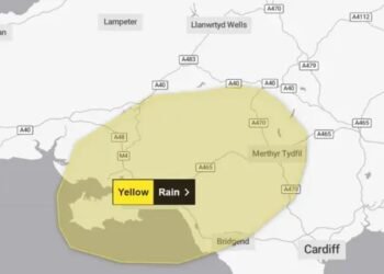
According to the Met Office, a broad “band of rain” will begin advancing eastwards on Tuesday, bringing unsettled weather conditions across England, Wales and Scotland. While sunshine may break through intermittently in the east, scattered showers are expected to dominate northern regions and western coastal areas. The rainfall is predicted to intensify overnight before heavier downpours arrive on Wednesday, moving once again from west to east. In some areas, rainfall rates could peak at an intense 32 millimetres per hour, leaving few places across the UK unaffected.
Meteorologists believe that the sudden change in conditions may be linked to the remnants of Hurricane Erin, which struck the United States last week. The storm has since weakened into a low-pressure system and is expected to descend on the British Isles, driving showers and prolonged periods of rain across much of the country. The Met Office has cautioned that from Saturday onwards, “showers or longer spells of rain will affect the majority of the UK at times,” signalling a decisive shift from the extended hot spell into a more autumnal climate pattern.
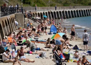
The return of unsettled conditions will bring an end to the elevated temperatures that characterised much of August. After highs of around 25°C on Tuesday, forecasters predict temperatures will fall below 20°C as September begins, aligning more closely with seasonal averages. This drop follows a holiday weekend in which parts of the country basked in near-record warmth. The Welsh village of Hawarden in Flintshire saw temperatures climb to 29.1°C, surpassing the nation’s previous August record of 26.5°C set in 1991. In Northern Ireland, Magilligan in Londonderry reached 24.5°C, exceeding its former record of 23.8°C.

Communities across Britain can therefore expect a noticeable change in both temperature and conditions in the days ahead. The Met Office’s extended outlook describes the period from Thursday to Saturday as “changeable,” with frequent showers particularly concentrated in western regions. Some of these will bring risks of thunder and gusty winds, making outdoor activities and travel more difficult. Meanwhile, eastern and southern parts of the country may experience slightly milder weather, but even there, rainfall and cooler air will be unavoidable.
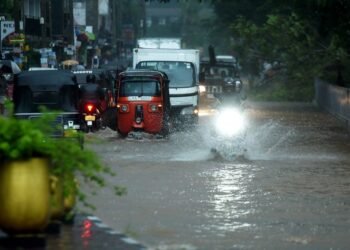
The unsettled forecast brings an end to a summer marked by contrasts—long spells of heat followed by abrupt storms. For farmers and businesses that depend on consistent weather, the arrival of heavy rain could prove both a blessing and a disruption. While the rainfall will provide much-needed relief for parched land after weeks of intense heat, the prospect of thundery showers and sudden downpours may also raise concerns about localised flooding, particularly in areas already experiencing strain on drainage systems.
Forecasters continue to monitor the shifting Atlantic weather patterns, with indications that the start of September could remain unsettled. While some respite from the rain is expected at intervals, meteorologists suggest that a sustained return to stable summer warmth is unlikely. As Britain braces for the transition into autumn, the coming week is expected to mark the definitive end of the season’s heatwave and the beginning of wetter, windier days ahead.
Related News:
 Severe Thunderstorms Lash England and Scotland: Met Office Issues Amber and Yellow Warnings Amid Flooding Risks
 UK Weather Update: Hottest Day of Heatwave Forecast with Chance of Temperatures Reaching 35°C
UK Weather: Heat Alerts Extended as Temperatures Set to Reach 30°C This Weekend
UK Weather Update: Hottest Day of Heatwave Forecast with Chance of Temperatures Reaching 35°C
UK Weather: Heat Alerts Extended as Temperatures Set to Reach 30°C This Weekend
 Typhoon Ragasa Batters Taiwan, Hong Kong and China
 Storm Amy Ravages UK: Fatalities, Widespread Travel Chaos, and Power Outages
 Storm Amy Wreaks Havoc Across UK and Ireland, Claims One Life
 Commuters warned as yellow snow and ice alert hits Northern Ireland
 Snow and Ice Cause Travel Chaos in North Yorkshire
 UK Energy Bills to Rise Slightly in January
 Trump EPA Moves to Roll Back Soot Pollution Limits
 Sri Lanka Floods Leave 56 Dead, Dozens Missing
 Kinnock’s Rebuke Echoes Loudly as Corbyn Allies Launch Left-Wing Breakaway: “A Gift to Farage”
 Post Office Scandal Compensation Tops £1 Billion as Victims Finally See Justice
 UK and Norway Forge Stronger Ties Through Joint Sanctions and Enhanced Defence Cooperation
 Exclusive: Leaked Documents Reveal Khan’s Controversial Road Policy Overhaul – Drivers Warn of ‘Final Nail in Coffin’
 UK Banks Granted Reprieve as BoE Delays Basel III Capital Rules Until 2028
 Trump Administration Dismisses 17 Immigration Judges, Sparking Debate Over Judicial Independence
 England Grapples with Unprecedented Bluetongue Virus Outbreak: Entire Nation Declared Infected Zone
 Justice Deferred, Not Denied: Government Orders Full Statutory Inquiry into Orgreave Clash Four Decades On
 Scorching Skies: England Gripped by Record-Breaking Heatwave Amid National Alerts
 Northern Ireland Family of Three Shot Dead in Maguiresbridge Home Incident
 Singapore Corruption Scandal: Details Emerge on Iswaran’s Luxury Flight and Ties to Tycoon Ong Beng Seng
 Fire Contained at Edinburgh’s Arthur’s Seat After Overnight Battle by Firefighters
 UK Heatwave Continues with Temperatures Soaring, Thunderstorms Forecast Across the Country
 Mystery Wallaby Spotted on Norfolk-Suffolk Border Sparks Police Appeal
 Peter Andre Breaks 16-Year Silence with Scathing Statement Against Katie Price
 Access to Iconic Cornish Beach Cut Off by National Trust Amid Safety Concerns
 Costa Blanca Holiday Horror as Food Poisoning Outbreak Hits Four-Star Hotel
 Hundreds of Swimming Pool Closures Leave Children ‘At Risk of Drowning’, Union Warns
 British Holidaymaker’s Tragic Death in Greece Confirmed as Drowning
 Denmark Investigates Professional Drone Incursions Across Multiple Airports, No Evidence of Russian Involvement
 Aston Villa Fight Back to End Winless Run with Convincing Victory over Fulham
 Arsenal Showcase Depth and Flexibility as Arteta Eyes Title Challenge
 UK Affirms No Relaxation of Visa Rules for India Amid Trade Push
 Women Challenge Meta Over Targeted Ads After Miscarriage
 Vice President Vance Warns of ‘Painful’ Job Cuts as U.S. Government Shutdown Deepens
 Japanese Court Sentences Man to Death for 2023 Quadruple Murder in Rare Gun and Knife Attack
 Zelensky to Urge Missile Aid as Trump and Putin Plan Summit
 Gibbs-White Inspires Forest to Thrilling Win Over Porto
 Manchester United triumph as Mbeumo brace seals thrilling win
 Hospice Cuts Raise Alarm Across England Amid Funding Crisis
 Tragedy on Lizard Island: Cruise Passenger Dies
 Fed Cuts US Interest Rates Again Amid Labour Market Uncertainty
 Zarah Sultana Launches Party to Change Politics
 Ex-Army Sergeant Jailed for Assault on Soldier Who Later Died
 US Senate Passes Funding Bill to End Historic Shutdown
 UK Faces Arctic Blast as Polar Vortex Disruption Brings Heavy Snow
 Mary Earps’s Manchester United Return Faces Mixed Reception
 Son Reveals UK Couple in Iran Resort to Hunger Strike for Help
 New weather warning issued with risk of flooding
 Pressure Mounts on Starmer to Sack Chief of Staff Over Briefing Row
 US Justice Department Files Lawsuit Against California Over Partisan Voting Maps
 Former Lion Heskey Warns of Shortage of England Strikers
 How Cultures Interpreted the Aurora Through History
 Orban Says Ukraine Has ‘No Chance’ as EU Support Continues
 Mother Watches in Horror as Teen Daughter Dies on Tracks
 Seven Countries, One Winner: Europe’s Best Christmas Market
 Israeli Strike Kills 13 Near Palestinian Camp in Lebanon
 Haiti Qualifies for World Cup Despite Coach Never Visiting Country
 US Judge Says Meta Did Not Hold Illegal Social Media Monopoly
 Serial Rapist and Former Cop Found Guilty Again
 Pentagon Officials in Ukraine to Discuss War End
 Ex-Harvard President Pauses Teaching Over Epstein Emails
 Vietnam Battles Deadly Floods as Rains Continue
 Scottish Families Take Legal Action Over School CO Leak
 Venezuela Threatens Nobel Winner Machado with Fugitive Status
 At Least Three Dead in Bangladesh Earthquake
 Vicki Fears Losing Motability Car
 Israel Confirms Hamas Returned Dror Or’s Body
 Millions Face Higher Taxes Under Reeves New Budget
 Two National Guard Soldiers Critically Injured Near White House
 Delhi’s Toxic Air Crisis Leaves Children Sick and Vulnerable
 Mbappe Scores 4 as Real Madrid Edge Olympiakos
 Scotland Gains 33 New Towns – Life in Growing Communities
 Jordan Bardella: France’s Young Presidential Contender
 AI Actress Creator Says Tilly Norwood Won’t Replace Actors
 Search underway for British man overboard off Tenerife
 Pavarotti statue frozen in Italian ice rink sparks backlash
 Barcelona, Atletico set for decisive La Liga showdown


