

Published: 11 September 2025. The English Chronicle Desk
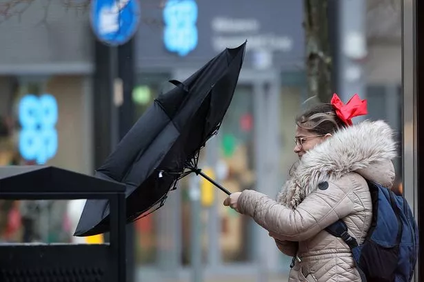
The UK Met Office has issued a severe weather warning as large parts of southern England, south-west England, Wales, and sections of the north-west prepare to face gale-force winds reaching up to 80 miles per hour. The yellow weather warning, which will be in effect for a prolonged 20-hour period from 8pm on Sunday until 6pm on Monday, is expected to affect millions of people and cause significant disruption across dozens of counties and major cities.
Forecasters have described the weather pattern as “unsettled,” with thunderstorms, heavy showers, and strong winds likely to sweep through much of the country as the weekend transitions into next week. The Met Office has cautioned residents in the affected regions to remain alert to changing conditions, with coastal areas particularly vulnerable to high winds and the risk of dangerous waves. While no named storm has yet been declared, the ferocity of the predicted gusts is causing widespread concern among emergency services, transport authorities, and local councils.

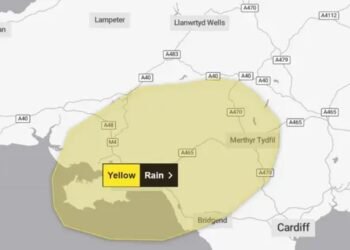
The warning stretches across a broad swathe of the country, from London and the South East through to the coastal counties of the South West and deep into Wales, with the North West of England also bracing for significant impact. Major urban centres including London, Cardiff, Bristol, Southampton, and Liverpool fall within the advisory zone. In total, 49 areas have been identified by the Met Office as likely to experience severe conditions, covering much of the country’s southern and western seaboard.
In addition to the looming threat of gale-force winds, the Met Office has predicted that showers will intensify on Friday evening, particularly in western coastal regions, before spreading more widely across England and Wales overnight. Saturday may bring heavy rainfall and even isolated thunderstorms, increasing the risk of localized flooding and travel disruption. The strongest winds are expected to develop late on Sunday, persisting into Monday, with coastal communities warned of possible structural damage, hazardous sea conditions, and delays to transport services both by road and rail.
Forecasters have also noted that in the far north-west of Scotland, the coming days are likely to bring spells of heavy rain combined with gusty conditions, although the most dangerous weather is expected further south. Across the rest of the UK, conditions will remain highly changeable, with brief spells of sunshine likely to be interrupted by intense showers, some accompanied by hail and thunder.
Authorities are urging residents in vulnerable regions to take precautions ahead of the stormy period, including securing outdoor furniture, checking travel updates, and exercising caution when travelling on exposed routes such as coastal roads, bridges, and elevated railways. Ferry services between the south coast of England and the Isle of Wight, as well as crossings into Wales, may also face disruption depending on the severity of conditions.
Despite the warnings, the Met Office has stopped short of declaring a named storm, emphasising that while the winds will be severe, they do not yet meet the threshold of the most destructive systems witnessed in recent years. Nonetheless, the strength of the forecast gusts, particularly along the coasts of Cornwall, Devon, Dorset, and Pembrokeshire, has prompted concerns over power outages, fallen trees, and potential delays to flights from regional airports.

The coming weekend therefore promises to be a test of resilience for many communities already accustomed to the erratic nature of the UK’s weather. With millions of households and businesses lying within the warning area, the next few days will demand vigilance, preparation, and patience as the country braces for what may be one of the most turbulent spells of weather seen this year.
Related News:
 Severe Thunderstorms Lash England and Scotland: Met Office Issues Amber and Yellow Warnings Amid Flooding Risks
 Scorching Skies: England Gripped by Record-Breaking Heatwave Amid National Alerts
 Tsunami Panic Grips Pacific Rim After One of Century’s Strongest Quakes Shakes Russia, Sparks Global Evacuations
 Storm Alert: Met Office Issues Thunderstorm Warning Across London and Southern England
 Massive Earthquake Off Russia’s Kamchatka Coast Sparks Widespread Tsunami Alerts and Volcanic Eruption
 Storm Floris Sparks Amber Alert in Scotland Amid ‘Danger to Life’ Wind Forecast
 Storm Floris Batters Northern UK With Ferocious Winds and Disrupts Travel Nationwide
 Storm Floris Slams the UK,‘Danger to Life’ Warnings as Ferocious 90mph Winds Cause Chaos Nationwide
 A Delicate Dance of Sunshine and Storms: UK’s Summer Forecast Holds Mixed Fortunes for Holidaymakers
 UK Weather Update: Hottest Day of Heatwave Forecast with Chance of Temperatures Reaching 35°C
 Fire Contained at Edinburgh’s Arthur’s Seat After Overnight Battle by Firefighters
 England Braces for Prolonged Dry Spell as National Drought Group Urges Urgent Water-Saving Measures
 England Faces “Nationally Significant” Water Shortfall as Fourth Heatwave of 2025 Strikes
 Europe Swelters Under Historic Heatwave as Wildfires Rage Across the Continent
 UK Heatwave Continues with Temperatures Soaring, Thunderstorms Forecast Across the Country
UK Weather: Heat Alerts Extended as Temperatures Set to Reach 30°C This Weekend
UK Heatwave Continues with Temperatures Soaring, Thunderstorms Forecast Across the Country
UK Weather: Heat Alerts Extended as Temperatures Set to Reach 30°C This Weekend
 Search Underway for Missing After Pakistan Flash Floods Kill Over 330
 K Braced for 600-Mile Rainstorm with Eight Counties Set to Escape Downpours
 UK Faces One of Its Warmest Summers on Record, Met Office Confirms
 UK Rocked by Two Earthquakes in Three Hours as Tremors Strike Cumbria and Iconic Welsh Landmark
 UK Weather Forecast: Rain and Storms to Break Summer Heatwave Across Britain
 Met Office Issues Urgent Rain Warning for Southeast England, Advises Residents to Prepare Emergency Kit
 Massive 641-Mile Storm Set to Batter UK with 15 Hours of Rain and Strong Winds
 UK Weather: Rain Expected Above Average This Autumn, but Drought Likely to Persist
 Yellow Weather Warning Issued as UK Braces for Winds Up to 80mph
 Typhoon Ragasa Batters Taiwan, Hong Kong and China
 Storm Amy set to disrupt travel across UK with winds reaching 95mph
Storm Amy Ravages UK: Fatalities, Widespread Travel Chaos, and Power Outages
Storm Amy Wreaks Havoc Across UK and Ireland, Claims One Life
Storm Amy set to disrupt travel across UK with winds reaching 95mph
Storm Amy Ravages UK: Fatalities, Widespread Travel Chaos, and Power Outages
Storm Amy Wreaks Havoc Across UK and Ireland, Claims One Life
 Everest Blizzard Chaos: Hundreds Stranded as Rescuers Battle Deadly Snowstorm
 What is anticyclonic gloom and why is it making the weather?
 UK braces for wet weekend as Met Office issues NI rain warning
 Hermer to face questions on alleged China spy case intervention
 Storm Benjamin Set to Lash UK with Heavy Rain and Strong Winds
 Biggest Supermoon of the Year to Dazzle Sky on Wednesday
 Delhi Tightens Curbs as Citizens Protest Over Toxic Air
 Northern Lights May Illuminate UK Skies Amid Strong Solar Storm
 UK Faces Arctic Blast as Polar Vortex Disruption Brings Heavy Snow
 Northern Lights may illuminate UK skies this week
 New weather warning issued with risk of flooding
Storm Claudia: Torrential Rain to Batter England and Wales
New weather warning issued with risk of flooding
Storm Claudia: Torrential Rain to Batter England and Wales
 Cold Snap Brings Snow Risk as Flood Recovery Continues
 Snow and Ice Warnings Affect Scotland and Northern England
 Thousands at Risk in Gaza Amid Winter Flooding
 Witnesses Recall Tragedy as Couple Die in Flood
 Commuters warned as yellow snow and ice alert hits Northern Ireland
 Arctic Blast Hits UK as Snow and Ice Warnings Trigger Travel Disruption
 West Councils Falling Behind on Climate Goals
 Africa Demands Climate Justice Linked to Colonial Past
 Snow and Ice Cause Travel Chaos in North Yorkshire
 Turkey to Host COP31 After Breakthrough Deal with Australia
 UK Energy Bills to Rise Slightly in January
 Trump EPA Moves to Roll Back Soot Pollution Limits
 Delhi’s Toxic Air Crisis Leaves Children Sick and Vulnerable
 Australia Launches Major Environmental Law Reforms
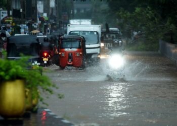 Sri Lanka Floods Leave 56 Dead, Dozens Missing
 Families wait in agony for missing after Hong Kong tower blaze
 Rare shark attack kills woman, injures man at remote NSW beach
 Delhi’s Toxic Air Drives Spike in Respiratory Illnesses
 ‘Extinct’ Antelope Returns to Sahara, Bringing Hope


