


Published: 29 August 2025.The English Chronicle Desk
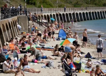
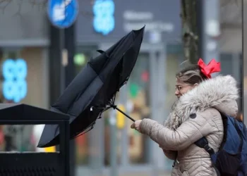
The Met Office has issued a stark warning to residents in 30 areas across the southeast of England, urging them to prepare an emergency kit as heavy showers and unsettled weather are set to disrupt the final days of summer. With wet and windy conditions expected to prevail, millions of people are bracing for intense downpours that could cause localised flooding and travel disruption.

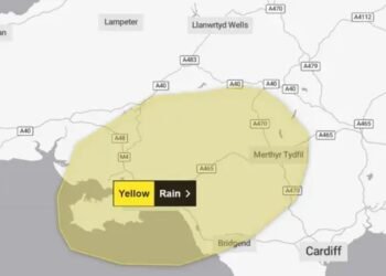
A yellow rain warning was in effect early Thursday morning, with forecasters also anticipating occasional thunder and hail in isolated areas. In the most affected regions, rainfall could reach 10 to 20 millimetres in less than an hour, while coastal areas may experience 50 to 70 millimetres over a few hours if heavy showers persist.
The Met Office cautioned: “Some flooding in these wetter areas is possible. A few showers could be accompanied by the odd rumble of thunder, more likely near the coasts. Heavy showers and rain should clear into the North Sea by early afternoon.”
Residents concerned about the potential impact of flooding have been advised to prepare both a flood plan and an emergency flood kit. Recommended items include torches with spare batteries, a mobile phone power pack, and other essential supplies to help households cope with possible power cuts or travel delays. The Met Office emphasised that early preparation can significantly reduce the disruption caused by severe weather.

The warning affects East England, London and the South East, and South West England. Forecasters predict that while heavy rain will gradually clear from the southeast through the morning, other parts of the country may see sunny spells interspersed with scattered, occasionally heavy, blustery showers.
Regarding tonight’s forecast, the Met Office reported: “Showers will ease away from the northwest, although some may continue along western coasts. Clear spells are expected across central and eastern areas, feeling cool under clear skies.”
Looking ahead to the weekend, showers are expected to continue affecting some coastal areas, while other regions should remain relatively dry. Saturday will see strong coastal winds and increasing cloud as heavy rain moves into the west. On Sunday, unsettled weather is likely to continue, with further rain and showers interspersed with sunny spells, accompanied by windy conditions and the risk of isolated thundery outbreaks. Temperatures are expected to remain near average.

The Met Office continues to monitor the situation closely, urging residents in vulnerable areas to remain vigilant, check local road and transport conditions, and ensure that emergency preparations are in place. As the UK faces a period of changeable late-summer weather, preparedness remains key to mitigating the impact on homes, travel, and daily life.
Related News:
 Severe Thunderstorms Lash England and Scotland: Met Office Issues Amber and Yellow Warnings Amid Flooding Risks
 Scorching Skies: England Gripped by Record-Breaking Heatwave Amid National Alerts
 Tsunami Panic Grips Pacific Rim After One of Century’s Strongest Quakes Shakes Russia, Sparks Global Evacuations
 Storm Alert: Met Office Issues Thunderstorm Warning Across London and Southern England
 Massive Earthquake Off Russia’s Kamchatka Coast Sparks Widespread Tsunami Alerts and Volcanic Eruption
 Storm Floris Sparks Amber Alert in Scotland Amid ‘Danger to Life’ Wind Forecast
 Storm Floris Batters Northern UK With Ferocious Winds and Disrupts Travel Nationwide
 Storm Floris Slams the UK,‘Danger to Life’ Warnings as Ferocious 90mph Winds Cause Chaos Nationwide
 A Delicate Dance of Sunshine and Storms: UK’s Summer Forecast Holds Mixed Fortunes for Holidaymakers
 UK Weather Update: Hottest Day of Heatwave Forecast with Chance of Temperatures Reaching 35°C
 Fire Contained at Edinburgh’s Arthur’s Seat After Overnight Battle by Firefighters
 England Braces for Prolonged Dry Spell as National Drought Group Urges Urgent Water-Saving Measures
 England Faces “Nationally Significant” Water Shortfall as Fourth Heatwave of 2025 Strikes
 Europe Swelters Under Historic Heatwave as Wildfires Rage Across the Continent
 UK Heatwave Continues with Temperatures Soaring, Thunderstorms Forecast Across the Country
UK Weather: Heat Alerts Extended as Temperatures Set to Reach 30°C This Weekend
UK Heatwave Continues with Temperatures Soaring, Thunderstorms Forecast Across the Country
UK Weather: Heat Alerts Extended as Temperatures Set to Reach 30°C This Weekend
 Search Underway for Missing After Pakistan Flash Floods Kill Over 330
 K Braced for 600-Mile Rainstorm with Eight Counties Set to Escape Downpours
 UK Faces One of Its Warmest Summers on Record, Met Office Confirms
 UK Rocked by Two Earthquakes in Three Hours as Tremors Strike Cumbria and Iconic Welsh Landmark
 UK Weather Forecast: Rain and Storms to Break Summer Heatwave Across Britain
 Massive 641-Mile Storm Set to Batter UK with 15 Hours of Rain and Strong Winds
 UK Weather: Rain Expected Above Average This Autumn, but Drought Likely to Persist
 Met Office Issues Urgent Weather Warning as 80mph Winds Threaten Millions Across the UK
 Yellow Weather Warning Issued as UK Braces for Winds Up to 80mph
 Typhoon Ragasa Batters Taiwan, Hong Kong and China
 Storm Amy set to disrupt travel across UK with winds reaching 95mph
Storm Amy Ravages UK: Fatalities, Widespread Travel Chaos, and Power Outages
Storm Amy Wreaks Havoc Across UK and Ireland, Claims One Life
Storm Amy set to disrupt travel across UK with winds reaching 95mph
Storm Amy Ravages UK: Fatalities, Widespread Travel Chaos, and Power Outages
Storm Amy Wreaks Havoc Across UK and Ireland, Claims One Life
 Everest Blizzard Chaos: Hundreds Stranded as Rescuers Battle Deadly Snowstorm
 What is anticyclonic gloom and why is it making the weather?
 UK braces for wet weekend as Met Office issues NI rain warning
 Hermer to face questions on alleged China spy case intervention
 Storm Benjamin Set to Lash UK with Heavy Rain and Strong Winds
 Biggest Supermoon of the Year to Dazzle Sky on Wednesday
 Delhi Tightens Curbs as Citizens Protest Over Toxic Air
 Northern Lights May Illuminate UK Skies Amid Strong Solar Storm
 UK Faces Arctic Blast as Polar Vortex Disruption Brings Heavy Snow
 Northern Lights may illuminate UK skies this week
 New weather warning issued with risk of flooding
Storm Claudia: Torrential Rain to Batter England and Wales
New weather warning issued with risk of flooding
Storm Claudia: Torrential Rain to Batter England and Wales
 Cold Snap Brings Snow Risk as Flood Recovery Continues
 Snow and Ice Warnings Affect Scotland and Northern England
 Thousands at Risk in Gaza Amid Winter Flooding
 Witnesses Recall Tragedy as Couple Die in Flood
 Commuters warned as yellow snow and ice alert hits Northern Ireland
 Arctic Blast Hits UK as Snow and Ice Warnings Trigger Travel Disruption
 West Councils Falling Behind on Climate Goals
 Africa Demands Climate Justice Linked to Colonial Past
 Snow and Ice Cause Travel Chaos in North Yorkshire
 Turkey to Host COP31 After Breakthrough Deal with Australia
 UK Energy Bills to Rise Slightly in January
 Trump EPA Moves to Roll Back Soot Pollution Limits
 Delhi’s Toxic Air Crisis Leaves Children Sick and Vulnerable
 Australia Launches Major Environmental Law Reforms
 Sri Lanka Floods Leave 56 Dead, Dozens Missing
 Families wait in agony for missing after Hong Kong tower blaze
 Rare shark attack kills woman, injures man at remote NSW beach
 Delhi’s Toxic Air Drives Spike in Respiratory Illnesses
 ‘Extinct’ Antelope Returns to Sahara, Bringing Hope


