


Published: 19 August 2025 | The English Chronicle Desk
The United Kingdom is preparing for what forecasters are describing as a vast 600-mile rainstorm expected to sweep across much of the country towards the end of the month. According to the Met Office and supporting data from WXC Charts, the storm system is due to begin around August 27, threatening to bring widespread downpours and unsettled conditions just as many people look ahead to the August bank holiday.
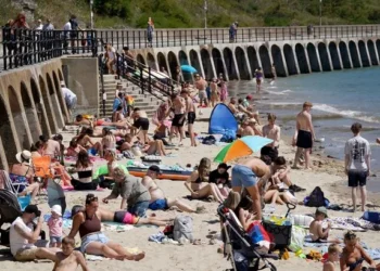
The Met Office’s latest forecast suggests a split in conditions across the country leading up to the storm. Sunday, August 17, was predicted to bring cloudier skies in the east while much of the west enjoyed brighter spells. The forecasters noted that low cloud would gradually clear inland, though some patches might linger along North Sea coasts. Sunshine elsewhere was likely to feel hazy at times, while strong gusty winds continued to affect the far southwest. Warm conditions were expected under the sun, though eastern regions were forecast to feel fresher where the cloud persisted.

As for the nights, clear skies were anticipated in the west, but the east and central parts of England were warned of occasional drizzle as low cloud returned. The southwest, meanwhile, was set to experience gusty conditions, especially over the Moors, a pattern which the Met Office said could continue in the coming days.
Looking further ahead, the final week of August carries a high degree of uncertainty, but the models suggest that Atlantic weather systems could dominate, particularly across northern and western parts of the country. This raises the prospect of widespread wind and rain, with the possibility of heavier and more prolonged downpours. The timing could not be more frustrating for those hoping for settled weather over the bank holiday weekend, as barbecues and outdoor gatherings may well be washed out.
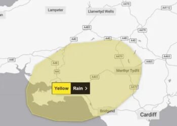
According to WXC Charts, the storm is expected to strike hardest in southern Scotland and the East Midlands, with those regions bearing the brunt of heavy rainfall and unsettled conditions. However, not all parts of the UK will be equally affected. Eight counties are forecast to escape the worst of the weather: Aberdeenshire, Somerset, Middlesex, Kent, Essex, Suffolk, Norfolk, and Cambridgeshire. These areas, for now, appear likely to miss the heaviest of the downpours that could stretch across hundreds of miles elsewhere.

The looming storm follows closely on the heels of yellow thunderstorm warnings issued just days ago. The warnings, which were put in place for several of the same counties now predicted to avoid the incoming storm, underlined the volatility of the current weather patterns as the UK shifts from summer into autumnal conditions.
As the date approaches, forecasters stress that the exact path and impact of the 600-mile rainstorm remain uncertain, with models still evolving. Nevertheless, the message from meteorologists is clear: large parts of the UK should prepare for a spell of unsettled, wet, and windy weather at a time of year when many had hoped for a final burst of summer warmth.
Related News:
 Storm Floris Sparks Amber Alert in Scotland Amid ‘Danger to Life’ Wind Forecast
 Storm Floris Batters Northern UK With Ferocious Winds and Disrupts Travel Nationwide
 Storm Floris Slams the UK,‘Danger to Life’ Warnings as Ferocious 90mph Winds Cause Chaos Nationwide
 A Delicate Dance of Sunshine and Storms: UK’s Summer Forecast Holds Mixed Fortunes for Holidaymakers
 Fire Contained at Edinburgh’s Arthur’s Seat After Overnight Battle by Firefighters
 England Braces for Prolonged Dry Spell as National Drought Group Urges Urgent Water-Saving Measures
 England Faces “Nationally Significant” Water Shortfall as Fourth Heatwave of 2025 Strikes
 UK Heatwave Continues with Temperatures Soaring, Thunderstorms Forecast Across the Country
 UK Weather: Heat Alerts Extended as Temperatures Set to Reach 30°C This Weekend
 UK Faces One of Its Warmest Summers on Record, Met Office Confirms
 UK Rocked by Two Earthquakes in Three Hours as Tremors Strike Cumbria and Iconic Welsh Landmark
 UK Weather: Rain Expected Above Average This Autumn, but Drought Likely to Persist
 Yellow Weather Warning Issued as UK Braces for Winds Up to 80mph
 Storm Amy set to disrupt travel across UK with winds reaching 95mph
Storm Amy Ravages UK: Fatalities, Widespread Travel Chaos, and Power Outages
Storm Amy Wreaks Havoc Across UK and Ireland, Claims One Life
Storm Amy set to disrupt travel across UK with winds reaching 95mph
Storm Amy Ravages UK: Fatalities, Widespread Travel Chaos, and Power Outages
Storm Amy Wreaks Havoc Across UK and Ireland, Claims One Life
 What is anticyclonic gloom and why is it making the weather?
 UK braces for wet weekend as Met Office issues NI rain warning
 Hermer to face questions on alleged China spy case intervention
 Storm Benjamin Set to Lash UK with Heavy Rain and Strong Winds
 Northern Lights May Illuminate UK Skies Amid Strong Solar Storm
 Northern Lights may illuminate UK skies this week
 New weather warning issued with risk of flooding
Storm Claudia: Torrential Rain to Batter England and Wales
New weather warning issued with risk of flooding
Storm Claudia: Torrential Rain to Batter England and Wales
 Cold Snap Brings Snow Risk as Flood Recovery Continues
 Witnesses Recall Tragedy as Couple Die in Flood
 Commuters warned as yellow snow and ice alert hits Northern Ireland
 UK Energy Bills to Rise Slightly in January
 UK Must Act with Courage and Clarity on Israel-Palestine Conflict, Says Foreign Affairs Committee Report
 London Set to Honour Euro 2025 Champions as Lionesses Take Victory Parade Through the Capital
 Targeted Attack in Bury Sparks Murder Investigation as Community Awaits Justice
 Princess of Wales Launches Animated Video Series to Support Early Childhood Development
 Heartbreak in the New Forest as Shetland Ponies Vanish, Community on Edge
 Premier League Supercomputer Predicts Tough Season for Man Utd Amid Three-Team Title Battle
 Palestine Action Ban Protesters Plan Tactic to Overwhelm Police at Next London Demonstration
 Grimsby Stun Manchester United in Dramatic Penalty Shootout
 Why E-Bikes and E-Scooters Are Making Streets a ‘Nightmare’ for Blind People
 Millions in the UK at Higher Risk of Heart Failure and Stroke Due to Air Pollution, Study Warns
 Prime Suspect in Madeleine McCann Case Declines Metropolitan Police Interview Ahead of German Prison Release
 Growing Crisis in UK Schools: One in Three Parents Seek Special Needs Assessments
 Zarah Sultana Seeks Legal Action After Bitter Clash with Jeremy Corbyn Over Party Membership Funds
 Mahmood Pledges Reform of Modern Slavery Laws After Court Blocks Deportation Appeal
 UK Government Backs Return of International Rail Travel to Kent Stations
 Arsenal VS Newcastle Hearts with Dramatic Late Turnaround at St James’ Park
 Ed Miliband Urges Labour to Confront Billionaire-Backed Opposition to Net Zero Goals
 Wetherspoon vows to keep prices low amid soaring energy and tax costs
 Teacher Permanently Banned After Slapping Pupil Over Classroom Incident
 Digital ID Plans Ignite Debate Over £600m Treasury Tax Boost and Privacy Concerns
 Millions in the UK at Risk of Cyber-Attacks as Microsoft Ends Windows 10 Updates, Warns Which?
 Public Trust in SNP Hits Historic Low Amid NHS Concerns
 Yvette Cooper Backs Digital ID Plan for UK Teens
 Strictly Celebs Starstruck as Cynthia Erivo Shines
 Ian Watkins Killed in Prison; Ex-Girlfriend Speaks Out
 Johnson Suggests Mandelson Linked to China Spy Controversy
 Ministry of Justice fails to file £11bn in spending receipts
 Rachel Reeves signals welfare reform ahead of key budget
 Reform UK candidate fined £19,000 after using AI-generated cases to challenge election
 Harry and Meghan join global AI leaders urging superintelligence ban
 William Steps Up Over Prince Andrew Palace Response
 Hospice Cuts Raise Alarm Across England Amid Funding Crisis
 Green Party Surges Past Labour in Latest UK Poll
 Zarah Sultana Launches Party to Change Politics
 Children to Learn Local History in Major Curriculum Overhaul
 Granit Xhaka Rescue Earns Everton Draw at Sunderland
 Prince William Plants Trees with Brazil’s Nature Heroes
 Just Stop Oil Protesters Convicted Amid Climate Defence Row
 King Charles to Lead Nation in Remembrance Sunday Service
 How to get help when a child goes missing – call 999 urgently
 Starmer Faces Growing Dissent as Labour MPs Weigh Leadership Challenge
 UK Faces Arctic Blast as Polar Vortex Disruption Brings Heavy Snow
 Son Reveals UK Couple in Iran Resort to Hunger Strike for Help
 Valve Opens the Door for Android Games on Steam
 Peers Flood Assisted Dying Bill with 942 Amendments
 Former Lion Heskey Warns of Shortage of England Strikers
 ‘Traumatic Wait’: Northern Ireland Women Face Breast Cancer Delays
 Serial Rapist and Former Cop Found Guilty Again
 Most Tories Expect to Support a Farage-Led Government
 Karen Carney Stuns on Blackpool Week, Deserves Strictly Final
 Fibromyalgia Patients Struggle as NHS Fails to Provide Care
 Virgin Media Fined £23.8m Over Telecare Safety Failures


