


Published: 02 May 2026. The English Chronicle Desk. The English Chronicle Online
Australia is set for a dramatic weather shift after an unusual burst of early May warmth that saw temperatures soar well above seasonal averages across several states, before an approaching cold front brings rain, thunderstorms and a sharp drop in conditions across the south-east.
The unseasonal warmth, which has affected New South Wales, Victoria, South Australia and Tasmania, is now expected to give way to a much cooler and more unstable weather pattern as a cold front sweeps in from the Southern Ocean. The change marks one of the most striking early autumn-to-winter transitions in recent years, with meteorologists warning of sudden temperature drops, heavy rainfall and storm activity in multiple regions.
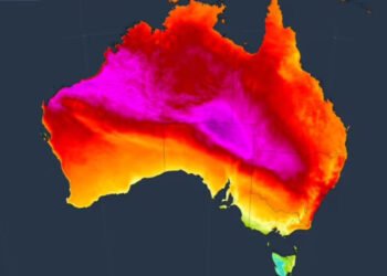
According to Australia’s national weather authority, the Bureau of Meteorology, the warm spell was driven by a strong high-pressure system that funnelled hot northerly winds across the south-east of the continent. This airflow pushed daytime temperatures to levels between 10 and 14 degrees Celsius above the seasonal average in several areas, creating conditions more typical of late summer than early winter.

In Victoria, the warmth was particularly intense, with cities such as Geelong, Shepparton and Bendigo recording their hottest May days on record. Temperatures climbed into the high 20s, surprising residents who had expected significantly cooler autumn weather. Tasmania also experienced record-breaking warmth, with Hobart reaching 26.9C and Launceston recording 24.3C, both setting new benchmarks for early May conditions.
Night-time temperatures also remained unusually high, with parts of South Australia, Queensland, Victoria, Tasmania and New South Wales experiencing overnight readings between eight and twelve degrees above average. This extended warmth contributed to what meteorologists described as a prolonged period of “unseasonably warm conditions,” which have persisted for several weeks leading into the weekend.
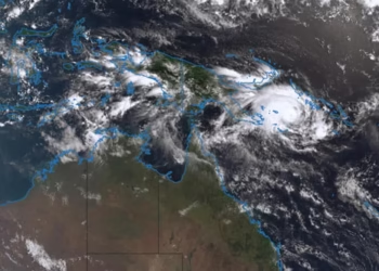
However, this pattern is now shifting rapidly as a cold front moving from the Southern Ocean merges with a cloud band over Western Australia. The combined system has strengthened into a significant weather front that is sweeping across South Australia before pushing towards Victoria and Tasmania, bringing with it a marked change in conditions.
Meteorologist Christie Johnson explained that the transition would be both fast and noticeable, especially after the recent warmth. She noted that cooler air has already begun extending across South Australia and into western Victoria, where maximum temperatures are expected to fall back into the high teens. The full impact of the cold air mass is forecast to reach south-eastern regions by Monday, bringing a significant drop in daytime temperatures and a much colder feel overall.
Johnson emphasised that the sudden shift would feel particularly sharp because of the preceding warmth. The contrast between recent record-breaking temperatures and the incoming cold air is expected to make the change more pronounced for residents, especially in areas that have recently experienced spring-like conditions.
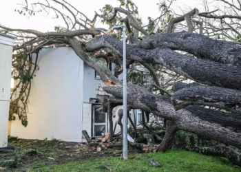
Alongside the temperature drop, the weather system is expected to bring widespread instability. Thunderstorms, heavy rainfall and strong winds are forecast across parts of South Australia, Victoria and Tasmania over the weekend and into the early part of the week. There is also a risk of severe storms in isolated areas, with potential for flash flooding due to intense rainfall in short periods.
Coastal regions may also experience abnormally high tides as the weather system interacts with atmospheric pressure changes. These conditions, combined with strong winds, could lead to hazardous conditions in exposed areas, particularly along southern coastlines.
While the south-east prepares for the cold front, Sydney is expected to remain largely unaffected by the most severe conditions. Forecasts suggest that the city will continue to experience relatively mild autumn weather, with temperatures remaining in the mid-20s for much of the week. Sunday is expected to reach around 26C, while Monday is forecast to bring rain with temperatures around 25C.
In contrast, Melbourne will see a more significant shift. Rain is expected throughout much of the week, with temperatures dropping from a Sunday maximum of around 23C to as low as 13C by Thursday. This rapid decline highlights the strength of the incoming cold air mass and its ability to reshape regional weather patterns within just a few days.
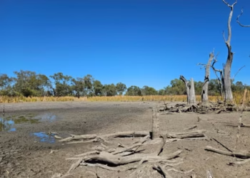
The broader weather pattern comes after Australia experienced its driest April since 2018, adding further complexity to the current transition. Dry conditions combined with sudden temperature swings can increase the risk of extreme weather events, particularly when unstable systems move in quickly after prolonged warmth.

Meteorologists have been closely monitoring the interaction between warm continental air and colder Southern Ocean systems, which has created the conditions for this rapid shift. The merging of these systems often leads to increased storm activity, as well as sharp contrasts in temperature and pressure across relatively short distances.
Experts say such fluctuations are not uncommon during seasonal transitions in Australia, but the intensity and speed of this particular change stand out. The combination of record-breaking warmth followed by a fast-moving cold front highlights the volatility of weather patterns during autumn, especially in southern regions of the country.
As the cold front continues its eastward movement, authorities are urging residents in affected areas to stay informed about local weather warnings, particularly regarding storms and potential flooding. Emergency services have also advised caution in low-lying areas and regions prone to rapid water accumulation during heavy rainfall events.
While the warm spell offered an unexpected taste of summer-like conditions in early May, the incoming cold front is expected to restore more typical seasonal temperatures across much of the south-east. However, the sharp contrast between the two systems is likely to leave a lasting impression, underscoring the increasingly unpredictable nature of weather patterns across Australia.
Related News:
 Ocean Warming Drives Massive Marine Life Loss, Study Warns
 BP’s Influence Sparks Controversy in UK STEM Education
 Record-Breaking Heat Looms Over South-East Australia as Catastrophic Fire Risk Escalates
 How Sandhill Ashes Rebuilt a Bushfire-Hit Rural Community
 AI Climate Claims Face Greenwashing Backlash
 Brace for Trump’s Brave New World of 1.7°C Global Warming
 Scotland’s Climate Plans Face Scrutiny Over ‘Science Fiction’ Targets
 Tropical Flowers Shift Blooming Due to Climate Crisis
 Musk’s xAI Permit Sparks Fury Over Power Plant Expansion
 ‘Drinking from a Fetid Pond’: Superbug Genes in Lough Neagh
 Evacuations Ordered as California Wildfires Spread Fast
 UK Records Earliest Spring as Nature Awakens Fast
 Queensland Braces for Potential Second Severe Cyclone Hit
 Heavier SUVs Accelerate Britain’s Pothole Crisis
 Big Tech Lobbies EU to Hide Massive Datacentre Emissions
 Governments Fail Murray-Darling River Projects
 Chornobyl Still at Risk 40 Years After Disaster
 Older Than Dinosaurs: Secrets of Mayfly Dance Revealed
 Capitalism ‘Suicidal’, Warns Petro at Climate Summit
 Virgin Trains Moves Closer to Challenging Eurostar Monopoly
 UK Bans Fake Numbers: Scammers Lose Their Trick
 Vibe coding’ named Collins dictionary’s word of the year
 Patients to Test Health at Home to Ease NHS Winter Pressure
 Britain deploys RAF specialists to assist Belgium with drone threats
 Stop using ChatGPT to write speeches, AI minister tells MPs
 Northern Lights may illuminate UK skies this week
 New laws to bolster UK’s defences against cyber attacks on NHS, transport and energy
 New AI tool could cut wasted efforts in organ transplants
 Sundar Pichai Cautions on AI Hype and Market Risks
 Google Chief Urges Caution: Don’t Trust AI Blindly
 ‘Extinct’ Antelope Returns to Sahara, Bringing Hope
 Eden Project Founder Celebrates 25 Years of Nature’s Hope
 Adelaide Festival Sparks Widespread Controversy Among Writers
 Storm Goretti leaves Cornwall homes without power
 US Clears Nvidia AI Chip Sales to China in Policy Shift
 Astronomers Prepare for First-Ever Movie of a Black Hole
 Sydney Shark Attack Surge Shocks Australia Beaches
 MPs warn AI financial risks threaten UK stability
 NSW Shark Attacks Surge, Authorities Urge Swimmers to Stay Out
 No Gas Boiler Ban as UK Warm Homes Plan Backs Heat Pumps
 Sussan Ley leadership milestone shakes Liberal future
 Deadly NSW Shooting Leaves Three Dead, Gunman Escapes
 Andrew Hastie Emerges as Leadership Rival to Ley
 Devon hosts first high-density hydro power system
 US-Style Pickup Trucks Surge on UK Roads
 Pornhub blocks new UK users over age checks dispute
 Amazon mistakenly signals new global layoffs to employees
 AI breast screening cuts later cancer diagnoses by 12%, study finds
 UK New Car Discounts Near £6,000 as Prices Are Slashed
 Wigan Dump Crisis Sparks Health and Safety Alarm
 What is Groundwater Flooding and Why Dorset is Seeing ‘Historical Highs’
 Most Statin Side-Effects Are Not Caused by Drugs, Study Confirms
 Gus Lamont Case: Grandmothers ‘Devastated’ by Major Crime Status
 Australia’s Opposition Coalition Reunites After Rift
 Dozens of Flood Warnings in England After Days of Non-Stop Rain
 BT Names New Openreach Chief Amid Major Fibre Expansion
 Tech Trends Set to Transform Life in 2026
 Temperatures Dip Below Freezing as Arctic Air Sweeps Across the UK
 NSW to Introduce Minimum Age for Ebike Riders
 How Do You Modernise Mango Farming? India’s Growers Urged to Innovate as Climate Change Hits
 ‘It’s a horrible feeling’: Loma Bropho’s Struggle to Secure Housing
 Germany Faces Backlash Over Scrapped Renewable Heating Mandate
 Stewart Brand on Musk, Bezos and a Life of Long Thinking
 Facial Recognition Error Leads to Wrongful Arrest in Milton Keynes
 UK’s First Geothermal Plant Powers 10,000 Homes
 Social Media Trial: Woman Says Addiction Began at Six
 Liberal Review Shelved After Historic Election Loss
 Study Says Only Two Nations May Survive Nuclear War
 Social Media Giant Trial Reaches Final Jury Decision
 Miles Jupp: How the Magic of the Ashes Sparked a Bold Blag
 The Toxic Scent Destroying Life in a Lancashire Town
 Tech Giants Condemn EU Over Lapse in Child Abuse Laws
 Southern Skies: High Turnout and Surprise Visitors in Birdwatch 2026
 Moldova River Crisis Exposes War’s Hidden Cost
 Fuel Prices Drop Despite Geelong Refinery Blaze
 Celestial Magic: The Lyrid Meteor Shower Returns
 Labor Reforms NDIS Amidst Mounting Budget Concerns
 Crackdown Backfires on UK Climate Protesters
 Renewable Energy as a Strategic Shield for UK Security
 Senator’s Anzac Day Post Sparks Online Music Controversy


