
Published: 13 August 2026 | The English Chronicle Desk | The English Chronicle Online
A rare combination of extreme ocean warming in the Pacific and a powerful developing El Niño is expected to reshape weather patterns across the western United States this autumn and winter, raising concerns about flooding, drought, wildfires, tropical storms and damage to marine ecosystems.
Scientists are closely watching an immense marine heatwave in the northeast Pacific that has persisted since forming in May 2025. Surface temperatures across parts of the region are already several degrees Celsius above average. At the same time, a major El Niño warming pattern is developing farther south and is forecast to strengthen during the autumn.
The two phenomena occurring together are unusual. Their interaction could amplify some of the effects normally associated with El Niño, while prolonging the ecological consequences of unusually warm ocean temperatures.
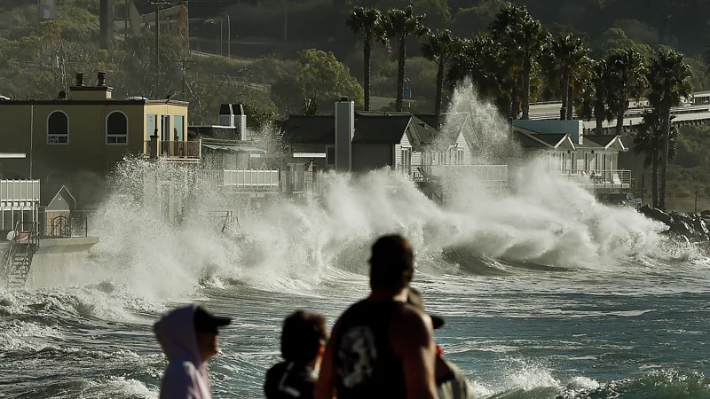
For communities along the US West Coast, the consequences could be particularly significant. Warmer coastal waters can contribute to higher sea levels, increase atmospheric moisture and alter storm behaviour. Inland areas may face heavier rainfall in some locations, while parts of the Pacific Northwest could experience reduced snowfall and worsening drought conditions.

The effects are also expected to extend beyond the atmosphere. Marine species living along the Pacific coast are already being exposed to prolonged periods of unusually warm water, raising concerns about food supplies, fisheries and the wider ocean ecosystem.
California faces heightened flood risks
California is among the regions expected to experience some of the strongest consequences from the combination of ocean warming and El Niño.
The state has already experienced a prolonged marine heatwave along parts of its coast. Researchers say coastal water levels are elevated and could rise further during the peak of the developing El Niño.
Higher background sea levels can significantly increase the frequency and severity of coastal flooding when storms arrive. Even relatively modest additional rises can make storm surges more damaging, particularly in low-lying coastal communities.
Warmer ocean water can also transfer additional heat and moisture into the atmosphere. That additional moisture can contribute to heavier rainfall and increase the likelihood of atmospheric rivers reaching California.
Atmospheric rivers are long, narrow corridors of concentrated water vapour that can deliver enormous amounts of rainfall when they move over land. While they are an important source of water for the western United States, particularly during wet winters, intense atmospheric rivers can also trigger flooding, landslides and mudslides.
The combination of elevated coastal water levels and potentially stronger rainfall therefore creates a complicated risk picture for California. A winter that brings much-needed precipitation could simultaneously create dangerous flooding conditions.
Pacific Northwest could see less snow
Farther north, the consequences may look very different.
Scientists expect El Niño and the marine heatwave to influence atmospheric circulation in ways that could reduce snowfall across parts of the Pacific Northwest and western Canada.
This matters because snowpack is an important source of freshwater. Mountain snow accumulated during winter gradually melts during warmer months, supplying rivers, reservoirs and agricultural systems.
If precipitation that normally falls as snow instead arrives as rain, water can run off more quickly while leaving less stored in the mountains for the following spring and summer.
There is precedent for this type of disruption. During the major Pacific marine heatwave known as “the Blob”, the Pacific Northwest experienced exceptionally low snowpack in 2015.
Scientists have linked the earlier event to changes in storm tracks and unusually warm conditions. The current heatwave has raised concerns that similar mechanisms could again affect the region.
The consequences could be particularly serious in areas already experiencing drought. Reduced snow accumulation could make water shortages more difficult to overcome, with some communities potentially requiring several wetter winters to recover.
Heat and wildfire risks remain a concern
Dryer conditions in the northwestern United States could also increase wildfire risks.
Northern California, eastern Oregon, southern Idaho and parts of the interior West are among the areas being watched as scientists assess the combined influence of the ocean warming and El Niño.
When soils and vegetation remain dry, fires can spread more easily and burn more intensely. Wildfires can also create significant economic costs through property damage, disruption to transport and infrastructure, emergency responses and deteriorating air quality.
Smoke from large fires can travel hundreds or even thousands of kilometres, affecting people far from the original blaze.
California could experience another aspect of the marine heatwave. Warmer waters can influence winds and atmospheric temperatures, potentially contributing to warmer and more humid conditions along and inland from the coast.
Researchers stress that the precise local effects will vary. Climate patterns such as El Niño change the odds of particular weather outcomes rather than determining exactly what will happen in every community.
Atlantic hurricanes could be suppressed
The developing El Niño may have an important effect beyond the Pacific.
In the Atlantic, El Niño generally increases wind shear, making it more difficult for thunderstorms and tropical disturbances to organise into hurricanes.
That could reduce hurricane activity in the Atlantic compared with what might otherwise occur.
The eastern Pacific, however, can experience the opposite effect. Warmer waters can provide additional energy to tropical systems, increasing the potential for stronger storms.
Mexico could therefore face heightened risks from eastern Pacific tropical cyclones during the season.
There is also a possibility that powerful storms could help weaken the marine heatwave itself. Strong winds can increase evaporation and bring cooler water into the upper ocean, reducing surface temperatures.
Researchers have previously observed major Pacific storms rapidly weakening marine heatwaves. Whether the current heatwave follows the same trajectory remains uncertain.
Marine life faces prolonged stress
The most severe long-term consequences may occur beneath the ocean surface.
Marine heatwaves can disrupt the normal movement of nutrients through the ocean. In the Pacific, seasonal upwelling normally brings colder, nutrient-rich water towards the surface, supporting plankton and the food chains that depend on them.
Excessively warm conditions can interfere with that process while reducing oxygen availability in parts of the water column.
Fish and shellfish may respond by moving into deeper or cooler waters. Others may experience increased stress or mortality.
The effects can spread throughout the ecosystem. Changes in the availability and distribution of prey can affect larger fish, marine mammals and seabirds.
Not every species loses from warmer water. Some warm-water species can expand their range or become more abundant. But researchers say the overall effect of a prolonged heatwave can be negative because ecosystem productivity may decline.
The experience of the previous Pacific “Blob” illustrates the scale of possible disruption. That event, which persisted for several years, produced major changes in marine ecosystems across the northeastern Pacific.
Scientists are particularly concerned about the duration of the current warming. Marine organisms have already been exposed to unusually warm conditions for an extended period, and the arrival of El Niño could expose them to another period of elevated temperatures.
Climate change is changing the background conditions
The emergence of major marine heatwaves with increasing frequency has also strengthened scientists’ focus on the role of climate change.
The ocean has absorbed more than 90% of the excess heat associated with human-driven global warming. Sea surface temperatures have risen substantially over recent decades, creating a warmer baseline from which extreme marine events can develop.
Researchers say marine heatwaves have become more frequent and intense as the world’s oceans continue to warm.
The current Pacific event is therefore not being considered in isolation. Scientists are examining whether what once appeared to be unusually rare ocean conditions are becoming a more persistent feature of the climate system.
At the same time, the precise relationship between climate change and individual El Niño events remains an area of active research. Scientists agree that global warming is altering the conditions in which these natural climate cycles occur, but determining how it will change the strength and frequency of particular events is more complicated.
An unusual combination to watch
The simultaneous presence of a major northeast Pacific marine heatwave and a powerful El Niño makes the coming months particularly important for climate scientists.
El Niño events typically persist for several months, and forecasts suggest the current warming pattern could reach its peak later in 2026 before gradually weakening.
The marine heatwave is more difficult to predict. Some marine heatwaves disappear relatively quickly when weather and ocean circulation change, while others can persist for years.
The uncertainty means that communities cannot assume that every predicted impact will occur with the same intensity. Instead, scientists are assessing the changing probabilities of extreme rainfall, coastal flooding, drought, wildfire and marine disruption.
For residents along the western coast of North America, the warning is less about a single catastrophic event than about a potentially unusual season in which several risks overlap.
Preparing for a changing Pacific
The coming autumn and winter will provide scientists with another important opportunity to understand how large-scale ocean warming and El Niño interact.
For policymakers and communities, the immediate challenge is preparation. Coastal authorities must account for elevated water levels when assessing storm and flood risks, while water managers in the Pacific Northwest must consider the possibility of reduced snowpack.

Fire agencies may also face difficult conditions if dry weather and heat persist across vulnerable parts of the West.
Meanwhile, fisheries and marine conservation authorities will continue monitoring changes in species distribution, ocean temperature and ecosystem productivity.
The broader lesson is that the Pacific Ocean is not simply a distant body of water influencing weather elsewhere. Changes in its temperature and circulation can affect rainfall, snowfall, wildfire conditions, tropical storms, freshwater supplies and marine ecosystems across a vast region.
As the developing El Niño strengthens, scientists will be watching closely to determine how the two warming patterns evolve and whether they reinforce or eventually weaken one another.
For now, the unusually warm Pacific represents a warning of how interconnected the climate system has become. The effects may be felt on beaches, in mountain snowfields, across wildfire-prone landscapes and deep beneath the ocean surface, making the months ahead a critical period for both weather forecasting and climate research.
Related News:
 Evacuations Ordered as California Wildfires Spread Fast
 Nearly 90,000 ordered to flee Reno wildfire
 Queensland Braces for Potential Second Severe Cyclone Hit
 Cyclone Vaianu Forces Mass Evacuations in New Zealand
 Sydney Records Hottest June Since 1859 as Expert Warns New High a ‘Signature’ of Global Warming
 Wildfires rage across Europe as hundreds arrested in France
 Heavy Casualties Feared as Flash Flood Sweeps Nepal-Tibet Border
 Australia Races to Find Tourists Missing in Nepal
 Nepal Flood Death Toll Tops 300 as Second Flood Feared
 Drought Raises Flood Risk as UK Autumn Approaches
 Nepal Rescuers Race to Save Hundreds Trapped Underground
 Nepal Flood Death Toll Tops 1,000 as Tunnel Search Intensifies
 Two National Guard Soldiers Critically Injured Near White House
 US National Guard Member Killed in DC Shooting
 American Mother Extradited From UK to U.S. on Murder Charges
 Federal Immigration Shift: Officers Leave Louisiana for Minneapolis
 Trump press secretary attacks reporter over ICE question
 Kyrsten Sinema Faces High-Profile Lawsuit Over Marriage Interference
 Greenland Crisis Forces Europe to Draw a Line With Trump
 China Halts Nvidia H200 Chips Despite US Export Approval
 Trump Fed bid heads to Supreme Court
 Historic Abu Dhabi Talks Bring US, Ukraine and Russia Together
 Partial US Government Shutdown Hits Homeland Security Funding
 Thousands Protest ICE Operations in Nationwide US Day of Action
 Sinema payment row deepens after $9,000 transfer claim
 US-Cuba Negotiations Shift as Oil Blockade Looms
 Nurses’ families fear breakup under UK immigration crackdown
 California Democrats Vow Trump Reckoning
 Trump’s Surgeon General Pick Evades Vaccine Questions
 Buffalo Refugee Tragedy: Border Patrol Neglect Leads to Death
 Ocean Warming Drives Massive Marine Life Loss, Study Warns
 New Poll Reveals Reform UK Stance on British Citizenship
 Adelaide University Faces Backlash Over Event Cancellation
 Ukraine war briefing: Zelenskyy offers help to Saudi Crown prince on combatting Iranian drones
 Utah Woman Found Guilty of Poisoning Husband for Inheritance
 UK Energy Reform Could Cut Bills by £200
 Trump Signals Hope for New Iran Talks as Ceasefire Fades
 Trump’s Presidency: A House of Cards Collapsing?
 Louisiana Tragedy: Eight Children Die in Mass Shooting
 Trump Starts $166bn Tariff Refund Process
 UK Stands Firm on Falklands Amid US Rift
 Crackdown Backfires on UK Climate Protesters
 Investigation Into Anti-Trump Motives After Gala Shooting
 Trump Defiant After Washington Hotel Shooting
 Identity Revealed: Suspected Washington Gunman Named
 Coalition pushes fossil fuel phaseout plan
 Trump orders US troop pullout from Germany
 Trump approval plunges amid Iran war fears
 Ohio’s Battle for Trust: Democrats Vying to Flip the Buckeye State
 US ‘Narco Boat’ Strikes Draw Global Outcry
 US Awaits Iran Reply on New Ceasefire Proposal
 Fear and Betrayal: The Chilling Case of Kouri Richins
 UK Faces Mass Water Shortages by 2055, Lords Warn
 Trump Sends 5,000 More US Troops to Poland
 Kevin Warsh sworn in as Fed chair amid economic backlash
 US green card applicants must apply from abroad, DHS says
 Pope Meets Families in Italy Toxic Waste Zone
 DeSantis’s ‘Alligator Alcatraz’ Faces Final Shutdown
 Trump’s Grip on the GOP Tested in Texas Senate Battle
 Trump Urged to Condemn UFC Fighter Over Obama Slurs
 US Military Pacific Boat Strike Kills Three People
 Is JD Vance the Ultimate Fall Guy for Trump’s Shaky Iran Deal?
 AOC Backs El-Sayed in Tight Michigan Senate Primary
 US Courts Back Trump on Park Signage Removals
 Trump’s Mount Rushmore Speech: A Divisive Anniversary
 Trump Intervenes in Fifa World Cup Balogun Ban
 US Airman Avoids British Court in Indecent Exposure Case
 UK Heatwaves Ignite Crisis of Sleep and Public Safety
 UK Schools Struggle as Classrooms Top 40C
 London Tube Heat Reaches Dangerous Levels
 Florida Executes One of Its Oldest Death Row Prisoners
 Olympus Awaits Unesco Heritage Recognition
 Houthis Strike Saudi Arabia as Middle East Tensions Rise
 Wildfires Force Mass Evacuations in France And Spain
 Powerful 7.7-Magnitude Earthquake Hits Eastern Indonesia
 Burnham unveils £65m drought aid for farmers
 Gen Z turns to BirdTok for a gentler digital escape
 Rain to return with thunderstorms and flood risk
 Families Fly to Nepal in Search of 33 Missing Britons
 Judge rules Trump administration unlawfully targeted Anthropic