
Published: 26 May 2026. The English Chronicle Desk. The English Chronicle Online.
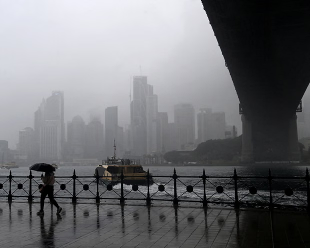
A severe weather system is gathering strength across the southern and eastern regions of Australia this week. The Bureau of Meteorology has issued urgent warnings regarding intense thunderstorms and extensive rainfall across multiple states. A significant low-pressure system is currently developing over South Australia and drawing heavy tropical moisture downwards. This powerful atmospheric combination is expected to trigger flash flooding and destructive winds over coming days. Residents across the eastern seaboard are preparing for volatile conditions after an unseasonably dry autumn period. Emergency services are advising local communities to monitor rapidly changing local forecasts and secure properties. The impending deluge highlights the volatile nature of transition periods within contemporary global weather patterns.
The immediate threat focuses heavily on Tasmania where severe weather warnings are actively in place. Meteorologists anticipate the most intense downpours will impact eastern parts of the island on Wednesday. The dangerous system is driven by a developing trough creating a strong easterly airflow pattern. This atmospheric structure effectively funnels massive amounts of coastal moisture directly into the regional environment. Rivers and local drainage networks face significant pressure as the ground quickly becomes completely saturated. Authorities are particularly concerned about localized flash flooding cutting off vulnerable rural transit routes overnight. The mountainous terrain of eastern Tasmania typically amplifies the velocity of sudden surface water runoff. Emergency teams have already positioned essential rescue equipment in high-risk areas across the state.
Beyond the southern island state the turbulent weather is tracking across New South Wales significantly. The central west regions will experience severe thunderstorms before the front moves steadily southward towards Victoria. These fast-moving storm cells are expected to impact communities late on Thursday evening across borders. Forecasters warn that the upper levels of the atmosphere are enhancing these unstable air masses. This internal atmospheric dynamic ensures that rainfall totals will accumulate much faster than normally expected. Some inland areas could see rainfall amounts exceeding one hundred millimetres over a short period. This sudden moisture provides some relief to agricultural sectors suffering from prolonged dry autumn soil. However the sheer intensity of the forecast drops poses an immediate threat to infrastructure stability.
Northern regions are also facing severe environmental challenges as the system expands across state borders. Southern Queensland is currently bracing for dangerous supercell storms capable of producing large destructive hail. Coastal areas and the inland Darling Downs region could see up to one hundred millimetres. Meteorologist Ilana Cherny confirmed that damaging winds remain a primary hazard for these northern communities. The focus of these severe storms will contract eastward toward the coast by Thursday afternoon. This shifting pattern places major metropolitan areas under direct threat of significant flash flooding events. Commuters are being warned to expect major travel disruptions on key transport corridors during peak hours. Local councils are clearing stormwater infrastructure to mitigate the impact of sudden intense downpours.
The true scale of this weather event becomes clear when examining regional rainfall accumulations. The New South Wales western slopes are anticipating between fifty and one hundred millimetres total. Meanwhile the coastal strips of New South Wales could experience up to one hundred fifty millimetres. This heavy coastal accumulation depends heavily on a low-pressure system forming just offshore on Friday. Even as the primary front moves out to sea moisture will continue wrapping around it. This circular movement ensures that coastal downpours will persist well into the upcoming weekend period. The prolonged nature of the event increases the likelihood of significant riverine flooding along coasts. Civil defence authorities are urging residents to avoid driving through any flooded roadways under circumstances.
The current extreme weather coincides with a significant update regarding global climate indicators this month. The Bureau of Meteorology has observed clear signs of El Niño development across the Pacific. Sea surface temperatures within the central tropical Pacific have shown substantial warming over recent weeks. Every sophisticated climate model reviewed by international scientists confirms this steady upward temperature trend. The data suggests that official El Niño thresholds will be reached before the winter concludes. This climate pattern typically suppresses rainfall across eastern Australia while driving up baseline daytime temperatures. The transition into this phase usually signals an increased risk of severe spring bushfires locally. Finding such intense current rainfall alongside an emerging El Niño presents a fascinating meteorological paradox.
Global scientists emphasize that the strength of an El Niño event remains somewhat uncertain today. Current predictive models indicate the phenomenon will register as at least moderate in overall strength. There is a distinct possibility of a strong event developing based on current metrics. The extent of central Pacific warming remains the primary metric used to calculate these projections. However authorities stress that sea surface temperatures do not automatically translate to predictable onshore impacts. Multiple competing climate drivers simultaneously influence the complex day-to-day weather patterns across the continent. This complexity explains why a drying climate signal can coexist with immediate extreme flood threats. The interaction between localized low-pressure systems and macro climate drivers remains difficult to map perfectly.
The preceding twenty-four hours have already delivered significant rainfall totals to several impacted states. New South Wales recorded up to sixty millimetres of rain during the initial storm phase. Meanwhile parts of Tasmania experienced seventy millimetres as the easterly trough began to settle in. South-east South Australia noted forty millimetres while Victoria received a more modest twenty millimetres total. These initial figures illustrate the widespread geographic footprint of this complex multi-state weather event. The unseasonal nature of these storms has caught some regional communities relatively underprepared for flooding. Insurance bodies are already advising property owners to document any early storm damage for claims. The economic impact of localized infrastructure damage could affect regional council budgets for months.
International climate agencies are watching the situation unfold with great interest from the northern hemisphere. The dramatic swing from extreme dry conditions to sudden flooding reflects broader global environmental trends. Heavy tropical moisture tracking so far south indicates highly active atmospheric rivers operating globally now. These systems transport vast quantities of water vapour outside traditional tropical zones with increasing frequency. The resultant rainfall events frequently overwhelm traditional civil engineering structures designed for historical climate norms. Australian authorities are continually updating long-term infrastructure designs to accommodate these increasingly erratic weather swings. The current storm cycle serves as a practical testing ground for these updated emergency protocols.
As the week progresses emergency agencies will maintain a high state of operational readiness. The Bureau of Meteorology will issue updated rolling warnings as new satellite data arrives hourly. Residents living in low-lying coastal valleys are being told to prepare basic evacuation packs. The combination of high tides and heavy coastal rain could create dangerous storm surge conditions. Local media outlets are broadcasting regular safety updates to ensure public awareness remains exceptionally high. The immediate focus remains on preserving human life and minimizing preventable damage to property. This major weather event will likely dominate regional news headlines as the cleanup begins. Australia faces a challenging dynamic period as it balances immediate floods against long-term warming trends.
Related News:
 Saudi Officials Report Zubaidi Flee Before Yemen Peace Talks
 UK Targets in New York Bomb Threat Hoax: Man Jailed
 Gambia Supreme Court Hears Case to Overturn FGM Ban
 Trump targets Iran trade with 25% tariff warning
 US Senate rejects resolution limiting Trump military powers
 Gulf states warn Trump Iran strikes risk wider Middle East war
 Machado Trump medal gesture reshapes Venezuela power struggle
 Geopolitical football: Iran, Trump and the World Cup clash
 Canada-China trade gains momentum in new strategic partnership
 Syria President Declares Victory as Ceasefire Reached with SDF
 Shinzo Abe’s killer receives life sentence in Japan
 China General Under Investigation Amid Leadership Purge
 Philippines ferry disaster leaves 15 dead, dozens missing
 Cambridge Faces Scrutiny Over Arms Investment Transparency
 Epstein UAE Emails Shake British Royal Andrew’s Legacy
 Christchurch gunman seeks to vacate guilty plea
 Concerns rise for Canberra boy amid Iran detention fears
 Ukraine Sends Drone Experts to Defend US Bases in Jordan
 Abramovich Chelsea Sale Cash Faces Jersey Probe
 Yvette Cooper: UK Must Follow Principles, Not US Pressure
 Jury Rules Meta and YouTube Liable for Addictive Design
 The Woman Guarding Earth From the Threat of Asteroids
 Exiled Tycoon Warns of New Russian Attacks on UK Soil
 LA 2028: Millions of Affordable Olympic Tickets Announced
 Trump Slams Europe as Transatlantic Tensions Boil Over
 Inside the Deceptive Machine: A Former Producer Speaks Out
 Spain Faces Backlash Over Xenophobic Chants in Egypt Draw
 A Global Voice For Justice: Stephen Lewis Dies At Age 88
 Hope and Fear as Iranians Flee Across the Turkish Border
 Reform UK Pledges To Halt Visas Over Reparations Demands
 US and Iran Agree to Two-Week Provisional Ceasefire
 Starmer visits Gulf as US and Iran agree ceasefire
 Gaza Child Arrives in UK for Life-Changing Care
 Pakistan Brokers Historic Peace Deal Amid Rising Tensions
 UK Holds Firm on Strait of Hormuz Amid Trump Pressure
 Trump Signals Hope for New Iran Talks as Ceasefire Fades
 Reeves Slams Trump Over Iran War Lack Of Exit Plan
 US and Iran Pursue Extension of Ceasefire via Pakistan
 Trump’s Islamabad Gamble: The High Stakes of a New Iran Deal
 Ian Katz to Step Down as Channel 4 Content Chief
 The General’s Gambit: Pakistan’s New Role in Global Peace
 Mexico, Spain and Brazil call for Cuba dialogue amid crisis
 Pakistan’s Ambitious Bid for Middle East Peace
 Israeli Soldiers Jailed Over Vandalism of Lebanese Statue
 Trump Weighs Sending Afghan Allies to the Congo
 Pentagon Shakes Up Navy Leadership Amid Hormuz Blockade
 Trump Threatens UK With Big Tariff Over Tech Tax
 Prominent Voices Challenge Palestine Action Ban
 Security Scrutiny After Washington Shooting Incident
 Merz Criticises US Approach in Iran Conflict
 UK Envoy Sparks Controversy Over Special Relationship Claims
 Ukraine Urges UK to Seize Russian Oil Tankers
 US Calls Australia Media Law “Foreign Extortion”
 The Billionaire’s Secretary and the £1m Fraud
 Ukraine strikes Tuapse as oil disaster worsens
 Brewing Tension: Taiwan Baristas Rebrand for World Stage
 Tensions Emerge in Netanyahu-Trump Alliance
 Mission to the World’s Edge: A Heroic Rescue in Tristan
 US and Mexico Face Heatwave as Floods Batter South Africa
 Mexico’s Missing: State Complicity in a Growing Crisis
 French Patient Told Hantavirus Was Just Anxiety
 The Long Way Home: Australia’s High-Stakes Virus Mission
 Putin Signals War End as Russian Momentum Stalls
 Romania’s Judicial Crisis: A System Under Siege
 Lee Lai Makes History with Landmark Stella Prize Victory
 Philippine Senator Flees After Days Under Senate Siege
 Alberta Separatist Bid Blocked by Canadian Court
 Canadian Court Blocks Alberta Independence Referendum Bid
 Big Tobacco Under Fire Over Controversial New Ad Campaign
 Bolsonaro Son Tape Scandal Sparks Massive Brazil Backlash
 Court Upholds Landmark Win for Transgender Rights
 Tragedy in the Maldives: Inside the Deep Sea Rescue
 Liberal Senator Criticises Immigration Rhetoric
 Senate Moves to Restrict Trump’s War Powers on Iran
 ICC Arrest Warrant Threat Sparks West Bank Retaliation
 Taliban Codifies Strict New Marriage and Divorce Legislation
 Tony Abbott Returns as New Liberal Party President
 Tulsi Gabbard exits after turbulent intelligence tenure
 Discontent grows around Putin amid war strain
 Trump Diplomacy Faces Hurdles from Tehran to Tbilisi