

Published: 11 May 2026. The English Chronicle Desk. The English Chronicle Online.
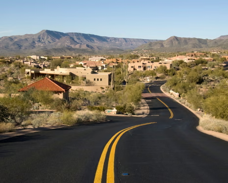
The natural world appears to be displaying its most extreme tendencies this week across two very different continents. Western regions of the United States and large swathes of Mexico are currently preparing for a significant heatwave. This atmospheric event is driven by a powerful ridge of high pressure that is settling over the area. Forecasters suggest that daytime highs will likely reach ten to fifteen degrees above the usual seasonal norms. Such sharp increases in temperature represent a significant challenge for residents and local infrastructure in these regions. The US National Weather Service has already acted by issuing heat advisories for California and Arizona. These warnings are particularly urgent for Monday and Tuesday in desert locations like the city of Palm Springs. Mercury levels there are expected to climb between forty and forty-three degrees on the Celsius scale. This intense heat is not expected to remain confined to the southwestern corner of the continent. Projections show the thermal energy will likely drift toward the midwest as the week progresses.
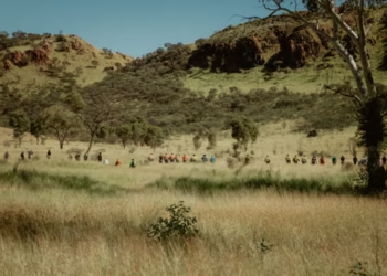
Meanwhile a very different and far more watery crisis is currently unfolding across South Africa. The southern parts of the country are battling severe weather conditions that include incredibly disruptive rainfall. Damaging winds are also sweeping through the region which significantly raises the risk of dangerous flooding. This weather system originally moved in from the Atlantic Ocean and reached the Cape on Sunday. Since then the rainfall has been persistent and has caused widespread concern for the local authorities. Between today and Wednesday some areas of the Western Cape may see two hundred millimetres of rain. The mountainous regions could see even more with totals potentially approaching three hundred millimetres of water. The South African Weather Service has been quick to issue several high level safety warnings. These alerts highlight the very real potential for flash flooding and dangerous local mudslides. Rockfalls are also a major concern along the steep coastal roads and mountain passes this week.

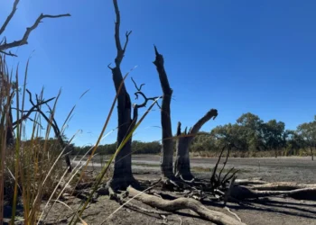
The heavy rainfall is unfortunately coinciding with powerful winds that are expected to cause further damage. Large areas of the southern coast including the Eastern Cape will experience very strong westerly gusts. These winds could exceed sixty miles per hour during the early stages of this current week. Higher ground and the Cape Fold Mountains are likely to see even more ferocious wind speeds. This latest bout of severe weather follows a tragic period of flooding just a few days ago. Between the fifth and seventh of May the region was already reeling from similar weather events. During that time more than three hundred millimetres of rain fell in some specific coastal areas. The Kouga dam exceeded its total capacity which forced many residents to leave their homes quickly. Evacuations in the Gamtoos Valley were necessary to ensure the safety of the local population. Power outages and dozens of road closures have left several small communities completely isolated and alone.
Tragically the human cost of these floods has already begun to manifest in the official reports. One person has died in Knysna which is a popular coastal town in the Western Cape. More than two thousand people have been forced to seek safety in various emergency shelters tonight. These displacement figures highlight the scale of the humanitarian challenge facing the South African government. Emergency services are working around the clock to restore power and clear the many blocked roads. Many of these routes are vital for the delivery of food and essential medical supplies. The combination of saturated ground and rising river levels makes the current situation extremely precarious indeed. Engineers are monitoring dams across the province to prevent any further uncontrolled overflows of water. Local charities are also on the ground to provide blankets and warm meals to those displaced. The resilience of these communities is being tested as the rain continues to fall heavily.
Across the ocean in the United States the focus is on prevention and public safety. Health officials are reminding people to stay hydrated and avoid outdoor activities during the peak heat. The elderly and those without air conditioning are considered to be at the highest risk. Cooling centres are being opened in major cities to provide a safe refuge from the sun. Farmers in Mexico are also worried about the impact of the heat on their seasonal crops. Prolonged exposure to such high temperatures can lead to significant losses in the agricultural sector. The ridge of high pressure creates a dome effect that traps heat near the ground. This phenomenon makes it very difficult for the air to cool down during the night. Lack of nighttime cooling places additional physical stress on the human body and the local environment. Meteorologists are watching the movement of this heat dome with a great deal of scrutiny.
The contrast between the parched landscapes of Arizona and the flooded streets of the Cape is stark. It serves as a reminder of how volatile the global climate has become in recent years. While one region prays for rain another is desperately hoping for the sun to return. In South Africa the focus remains on search and rescue operations in the most affected districts. The damaging winds have also made it difficult for helicopters to reach some of the stranded people. As the winds subside it is hoped that aerial support can be fully utilised once more. In the US and Mexico the primary goal is to manage the peak energy demand. Air conditioning units will be running at full capacity which puts a strain on power grids. Utility companies have urged consumers to be mindful of their electricity usage during the coming days. Everyone is watching the skies closely as these two distinct weather stories continue to develop.
The economic impact of these weather events will likely be felt for many months to come. Rebuilding infrastructure in South Africa will require a significant amount of financial investment and time. Damaged bridges and washed out roads are expensive to repair and vital for the local economy. In the western US the heat could trigger an early start to the wildfire season. Dry vegetation becomes highly flammable when subjected to the kind of heat currently being forecast today. Forestry departments are already on high alert for any signs of smoke in the wilderness areas. The intersection of these two events highlights the global nature of modern meteorological monitoring and reporting. Information is shared rapidly between international agencies to ensure that everyone is as prepared as possible. The English Chronicle will continue to provide updates as these situations evolve on both continents. For now the world watches as nature demonstrates its incredible and often destructive power.
Related News:
 Shock US Raid: Maduro Pleads Not Guilty in Manhattan Court
 UK and France Agree Troop Deployment Plan for Ukraine
 EU Weakens as Trump Targets Venezuela and Greenland
 Venezuela Oil Deal Opens Tensions with US Control
 US Citizens Warned to Venezuela Flee Amid Paramilitary Threats
 Gulf states warn Trump Iran strikes risk wider Middle East war
 Machado Trump medal gesture reshapes Venezuela power struggle
 Greenland defence seen as shared Nato duty amid troop arrivals
 Gulf states warn Trump Iran strikes risk wider Middle East war
 Trump Receives Machado’s Nobel Medal in White House Meeting
 Iran unrest slows under brutal crackdown and global tensions
 Syria President Declares Victory as Ceasefire Reached with SDF
 US Considers Asylum for British Jews Amid Rising Antisemitism
 Russia Strikes Kyiv and Kharkiv as Peace Talks Enter Day Two
 Thousands Protest ICE Operations in Nationwide US Day of Action
 Epstein Files Reveal Trump Officials’ Emails with Financier
 Thousands Protest ICE in New York Against Trump Deportation Campaign
 Christchurch Shooter Seeks to Overturn Guilty Plea in Appeals Court
 Sydney Protest Pepper Spray Clash During Herzog Visit
 Cuba Kills Exiles in Speedboat Attack from US Waters
 Yvette Cooper: UK Must Follow Principles, Not US Pressure
 Saudi Arabia Urging US to Keep Up Iran Attacks
 Washington Enlists Musk to Battle Global Hostility Online
 Teen Girl Charged After Alleged Melbourne Hate Crime Spree
 Macron Urges Stability as Trump Jolts Nato and Iran
 Trump Address Sparks Global Backlash Over Iran War Tactics
 Macron Rebukes Trump Following Mockery of His Marriage
 Trump Sets Tuesday Deadline for Iran to Reopen Vital Strait
 Tragic End to Outback Search as Floods Claim a Life
 Ben Roberts-Smith Arrested Over Alleged War Crimes
 Bondi Nanny Adriana Rivas to Face Extradition to Chile
 Trump and Tehran Find Common Ground in Landmark Ceasefire
 Netanyahu Vows Continued Lebanon Strikes Amid Peace Talks
 Trump Predicts Rapid Return to Peace Talks in Pakistan
 Reeves Slams Trump Over Iran War Lack Of Exit Plan
 US and Iran Pursue Extension of Ceasefire via Pakistan
 Pope Leo Calls for Global Unity Following Trump Criticism
 Trump Brokers Ten Day Ceasefire to Halt Lebanon Conflict
 Mexico, Spain and Brazil call for Cuba dialogue amid crisis
 Tensions Flare as Iran Rejects New Peace Talks with US
 Ukraine Urges UK to Seize Russian Oil Tankers
 US Calls Australia Media Law “Foreign Extortion”
 Oil Prices Surge Above $120 Amid Iran Blockade Fears
 Tragic End to Search for Missing Girl in Alice Springs
 Questions Remain Over The Tragic Bondi Massacre
 Trump orders US troop pullout from Germany
 Activists allege abuse after Gaza flotilla seizure
 Ukraine strikes Tuapse as oil disaster worsens
 Global order shifts amid Trump-era turmoil
 Japan Protests Erupt Over Plans to Revise Constitution
 Australia pushes Pacific security pact amid China tension
 Indiana Republicans Defy Trump in Key Vote Test
 Middle East Crisis Escalates as Oil Routes Shake Markets
 FIFA Confirms Global Ban for Benfica Star Prestianni
 New South Wales Wetland Rescue Legislation Passes
 Tensions Emerge in Netanyahu-Trump Alliance
 Putin Declares Russia Victory at Scaled Victory Day Parade
 BBC to Apologise Over Edited Trump Speech Amid Backlash
 Greene Pushes Epstein Files Amid Trump Fallout
 Zelenskyy Signs Fighter Jet Deal Amid Russian Drone Attacks
 Shadow Fleet at Sea: Europe’s Battle Against Illicit Oil Shipping
 US Suspends Afghan Immigration After White House Shooting
 US Senate rejects resolution limiting Trump military powers
 Sydney Shark Attack Surge Shocks Australia Beaches
 Portugal Election Delivers Socialist Win as Far Right Surges
 Australian Families Leave Syrian Camp for Home
 Drugs, Denial, Stigma: Fiji’s HIV Crisis Hits Children
 Hilary Knight speaks out on Trump’s recent hockey remarks
 Penny Wong silent on Australian crew in sub strike
 Trump Pressures Congress Over Save America Act
 Goma Drone Attack Kills Three as Conflict Escalates
 Queensland Protest Laws Spark Free Speech Backlash
 Trump Nato threats expose Iran strategy vacuum
 Trump Facing Backlash from Epstein Survivors Over Files
 Report Says Pezzullo Acted ‘Recklessly’ in Dealings
 Starmer visits Gulf as US and Iran agree ceasefire
 Tragedy Strikes Outside Melbourne Comic Con
 Prominent Voices Challenge Palestine Action Ban
 US to Escort Trapped Ships Through the Strait of Hormuz
 US Awaits Iran Reply on New Ceasefire Proposal


