
Published: 21 September 2026. The English Chronicle Desk. The English Chronicle Online.
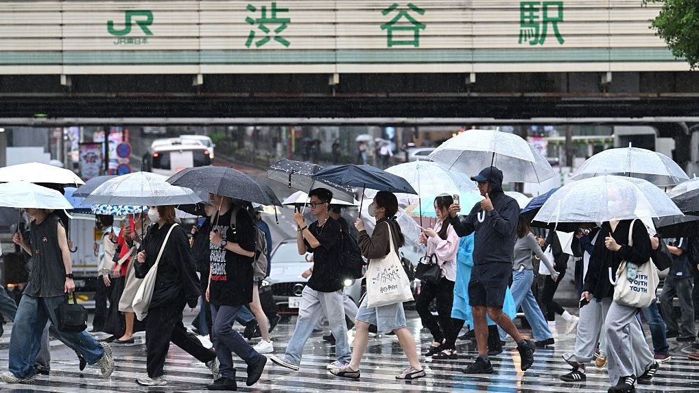
Japan is preparing for another round of dangerous weather as Tropical Storm Dujuan moves close to the country’s Pacific coast and is expected to regain typhoon strength. The storm has already brought heavy rainfall to parts of eastern Japan, while authorities have warned of flooding, landslides, powerful winds and dangerous coastal conditions, particularly across the Izu Islands and the wider Kanto region.
Dujuan briefly reached typhoon strength on Friday before weakening to a tropical storm on Sunday. Forecasts indicate that the system could strengthen again as it approaches eastern Japan, with sustained winds potentially reaching around 80mph and stronger gusts. The storm is expected to continue moving north-eastwards before eventually weakening over the north-western Pacific.
Although the centre of Dujuan is not expected to make a direct landfall on Japan’s main island, its large circulation is capable of producing severe weather over a wide area. The Izu Islands are among the areas facing the greatest immediate danger, with authorities issuing evacuation-related warnings as heavy rain and strong winds move through the region.
The Japan Meteorological Agency has warned of torrential rain, violent winds and a heightened risk of landslides and flooding. Recent rainfall has already exceeded 300mm in some locations, while further intense precipitation is expected as the storm approaches the eastern Pacific coast. The combination of saturated ground and additional rainfall increases the possibility of landslides, river flooding and sudden inundation in vulnerable areas.

Tokyo and surrounding parts of the Kanto region are also being closely monitored. Forecast rainfall totals could become exceptionally high in a short period, raising concerns for urban drainage systems, transport networks and low-lying communities. Southern parts of the Chubu and Kanto regions could receive around 200mm of rain within 24 hours, while some locations may experience particularly intense rainfall over only a few hours.
The Izu Peninsula is also expected to face periods of intense rain. Such concentrated rainfall can rapidly increase the risk of flash flooding, especially where rivers, drainage channels and slopes are already under pressure. Japanese authorities have urged people in affected areas to follow evacuation instructions and avoid unnecessary travel during the most dangerous periods.
High waves represent another major threat. The storm’s large wind field is expected to generate dangerous seas around the Izu Islands and along Japan’s eastern Pacific coastline. Residents and visitors in coastal areas have been warned to stay away from exposed shorelines, as large waves and storm-driven conditions can become hazardous even away from the centre of the cyclone.
The storm is also having wider effects on daily activities. Weather-related disruptions have affected transportation and sporting schedules, with officials monitoring conditions around events being held in Japan. The ongoing Asian Games in Aichi-Nagoya have also faced weather-related disruption, including a postponement of an equestrian event as organisers responded to the approaching storm.
The situation illustrates how tropical systems can affect countries even when their centres remain offshore. A storm does not need to cross directly over a major city to produce damaging rainfall, high winds or coastal hazards. Dujuan’s broad circulation means that communities far from the centre can still experience significant weather impacts.
Japan’s geography adds another layer of vulnerability. Mountainous terrain, densely populated urban areas and extensive coastal development mean that intense rainfall can create several risks at the same time. Heavy rain can destabilise slopes, cause rivers to rise quickly and overwhelm drainage systems, while strong winds and high waves can disrupt transport and coastal activities.
As Dujuan moves north-east, forecasters expect its structure to change and gradually lose its tropical characteristics. The storm is expected to move away from the Japanese mainland before eventually weakening over the Pacific later in the week. However, authorities remain focused on the immediate period of heavy rain and strong winds as the system passes close to eastern Japan.
While Japan confronts Dujuan, the Atlantic hurricane season is presenting a very different picture. Tropical Storm Fay has developed in the eastern Atlantic near the Azores, becoming the sixth named storm of the 2026 Atlantic season. As of Monday, Fay had strengthened to around 70mph in sustained winds but was forecast to begin weakening, with no coastal watches or warnings in effect.
Fay’s development has attracted attention because of the unusually slow pace of the Atlantic hurricane season. No Atlantic hurricane had formed by the middle of September, making the first hurricane formation exceptionally late in the satellite-era record. Fay itself was expected to remain away from major land areas and eventually transition into a post-tropical system.
The contrast between the western Pacific and Atlantic highlights the highly variable nature of tropical cyclone activity. While Japan is dealing with a significant storm threat, the Atlantic has remained comparatively quiet despite the seasonal potential for tropical development.

Meanwhile, another weather pattern is emerging across south-western Europe. Spain and Portugal are expected to experience a late-season spell of unusually warm weather, with temperatures rising well above the September average in several areas. Some parts of the Iberian Peninsula could see temperatures reaching the low to mid-30s Celsius.
Northern and north-western Spain could also experience unusually high temperatures. Santiago de Compostela, for example, could approach 35C, considerably above its typical daytime temperature for September. The warmth is expected to spread towards parts of central Europe later in the week, although forecasts suggest the intensity may be lower than that experienced across the Iberian Peninsula.
Taken together, the weather developments across Japan, the Atlantic and Europe demonstrate the contrasting conditions being experienced across different regions at the same time. Japan is facing the immediate threat of torrential rain, flooding, landslides and powerful winds from Dujuan, while the Atlantic is experiencing a relatively subdued hurricane season and parts of Europe are preparing for another burst of summer-like temperatures.
For Japan, however, the priority remains the storm’s immediate impact. Authorities continue to monitor rainfall, river levels, wind conditions and landslide risks as Dujuan approaches. Residents in vulnerable areas are being urged to remain alert, follow official warnings and prepare for rapidly changing conditions. The storm’s eventual departure from Japan should bring a gradual improvement, but the period surrounding its closest approach remains critical for communities across eastern Japan.
Related News:
 Nepal Rescuers Race to Save Hundreds Trapped Underground
 Nepal seeks $20m climate compensation after deadly floods
 Cyclone Vaianu Forces Mass Evacuations in New Zealand
 Venezuela Quake Death Toll Surpasses 4,000
 Powerful 7.7-Magnitude Earthquake Hits Eastern Indonesia
 Wildfires rage across Europe as hundreds arrested in France
 Heavy Casualties Feared as Flash Flood Sweeps Nepal-Tibet Border
 Australia Races to Find Tourists Missing in Nepal
 Nepal Flood Death Toll Tops 300 as Second Flood Feared
 Nepal-Tibet Flood Death Toll Rises as 2,478 Remain Missing
 UN Warns Record El Niño Could Supercharge Global Heat
 Nepal Flood Survivors Face Unimaginable Loss
 Nepal Tunnel Rescue Offers Hope Amid Flood Devastation
 Typhoon Saudel Triggers Mass Evacuations in China
 Storm Leonardo Triggers Election Delay Calls in Iberia
 Nine Killed in Karachi Consulate Protest
 North Korea Fires Missiles Amid US-South Korea Drills
 Evacuations Ordered as California Wildfires Spread Fast
 Queensland Braces for Potential Second Severe Cyclone Hit
 Chornobyl Still at Risk 40 Years After Disaster
 Southeast Asia Turns to Russia Amid Energy Crisis
 Escobar’s Hippos May Be Moved to India Zoo
 Capitalism ‘Suicidal’, Warns Petro at Climate Summit
 Coalition pushes fossil fuel phaseout plan
 China Fireworks Factory Blast Kills 21 in Hunan
 Australia pushes Pacific security pact amid China tension
 BJP Sweeps West Bengal in Historic Breakthrough
 Norway Doubles Down on Oil and Gas for Europe Energy Security
 Doomsday Clock Nears Midnight Amid Global Crises
 US Awaits Iran Reply on New Ceasefire Proposal
 One Nation Stuns Australia With Historic Farrer Win
 Hormuz Talks Near Critical Stage
 China mine blast death toll rises to 90
 Maldives Cave Diving Tragedy Raises Safety Alarm
 Pope Meets Families in Italy Toxic Waste Zone
 Discontent grows around Putin amid war strain
 UN Issues Urgent Warning: Imminent Return of El Niño
 Germany Summons Chinese Envoy Over Russian Troop Training
 Sydney Records Hottest June Since 1859 as Expert Warns New High a ‘Signature’ of Global Warming
 Millions Gather for Khamenei’s Six-Day State Funeral
 Olympus Awaits Unesco Heritage Recognition
 Houthis Strike Saudi Arabia as Middle East Tensions Rise
 Wildfires Force Mass Evacuations in France And Spain
 Taliban global ties grow as rights fears mount
 Seoul proposes historic peace talks to replace Korean War armistice
 Israeli Strike in Southern Lebanon Kills Seven
 Five Years of Taliban Rule Leave Afghanistan in Crisis
 Families Fly to Nepal in Search of 33 Missing Britons
 Turkmenistan Begins Fixing Major Methane Mega-Leaks
 Nepal Flood Death Toll Tops 1,000 as Tunnel Search Intensifies
 Daughter Finds Bones in Parents’ Burned-Out Car
 North Korea Expands Uranium Facility at Yongbyon
 Saudi Arabia Shuts Oil Pipeline After Drone Attack
 Nearly 50,000 Flee as Houthis Advance in Yemen

 Indonesia Receives First Aircraft Carrier
 South Korea Rules Out Military Role in Iran War
 Saudi Pact Raises Risk of Pakistan Entering War
 Europe Faces Climate Reckoning After Extreme Summer
 Middle powers seek new alliances amid Trump era
 Zelenskyy Signs Fighter Jet Deal Amid Russian Drone Attacks
 Shadow Fleet at Sea: Europe’s Battle Against Illicit Oil Shipping
 US Suspends Afghan Immigration After White House Shooting
 ‘Extinct’ Antelope Returns to Sahara, Bringing Hope
 Irish Beach Tragedy: Irish Drown at Whitehaven Beach in Australia
 UK and US Drop in Global Corruption Index Rankings
 Canberra Poster Seizure Sparks Free Speech Row
 Jacinda Ardern Move Sparks Kiwi Reflection
 Middle East Airspace Crisis Strands Thousands
 Kelly Wilkinson Inquest Reveals Bail Failure
 Injured Mojtaba Khamenei Elevated as Iran Leader
 The Kill Line: A Shifting Vision of the American Dream
 Air Canada CEO Faces Outcry Over Recent Language Misstep
 Extreme Weather: Europe Shivers as Cyclone Narelle Hits
 Britain’s Crowning Butterfly Takes the Nation by Storm
 Fifa Official Under Investigation Over Hand Gesture Controversy
 Grief and Devotion Amidst the Rubble of Nabatieh
 England and Norway Fans Turn Miami Into World Cup Carnival
 Nepal-Tibet Flood Leaves 270 Dead and 1,400 Missing
 Bayeux Tapestry Revives Franco-British Ties