
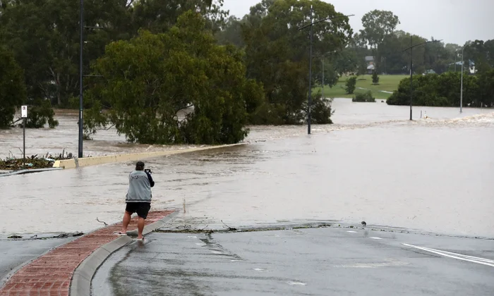
A man has been found dead in floodwaters in Queensland as an unusual weather system brought days of torrential rain, powerful thunderstorms and widespread flooding to parts of eastern Australia, leaving rivers swollen, roads submerged and emergency crews working to rescue stranded residents and travellers.
The man was discovered in Smothering Creek on Boompa Road, in the Fraser Coast region of Queensland, after emergency services received reports shortly after 11am on Monday that someone had been found unresponsive in the water. Queensland police confirmed that the man was declared dead at the scene. Authorities have launched an investigation into the circumstances surrounding his death and will prepare a report for the coroner.
Police have not publicly established the circumstances that led to the man being in the creek. The discovery came as large parts of Queensland continued to experience the consequences of sustained heavy rainfall, with emergency authorities warning that additional rain and flooding remained possible.

The incident highlighted the dangers posed by rapidly rising waterways during prolonged periods of severe weather. Floodwater can conceal submerged obstacles, damage road surfaces and create powerful currents, making creeks, rivers and flooded crossings particularly hazardous even after the heaviest rainfall has passed. Emergency services continued to respond to weather-related incidents across the state as communities assessed the effects of the deluge.
Further south, emergency crews rescued six campers who became stranded by floodwaters at a public campground in Leyburn, in Queensland’s Southern Downs region. Queensland Fire and Rescue swiftwater rescue teams were called to assist at approximately 7.45am on Monday after the group found themselves unable to leave safely because of the rising water.
The rescue operation involved three men aged 71, 47 and 26, and three women, including a 68-year-old and a 26-year-old. The six campers were brought to safety at about 11.15am, according to information released by authorities. Police reported no physical injuries among those rescued.
The incident demonstrated how quickly conditions can deteriorate in camping areas situated near creeks and other waterways. Heavy rainfall upstream can cause water levels to rise rapidly, potentially cutting off access routes and leaving people isolated even when rainfall at their immediate location appears less severe.
Authorities across Queensland were also dealing with flash flooding in the Lockyer Valley, west of Brisbane. Laidley Creek and Glenore Grove were among the areas affected, with some roads closed as floodwaters disrupted local travel. Road closures and inundated crossings added to the challenges facing motorists, emergency personnel and people attempting to reach their homes or workplaces.
The flooding followed torrential downpours that affected parts of Queensland from Thursday through Monday. The prolonged rainfall left numerous rivers and roads flooded across the state’s southern and eastern regions, while meteorologists warned that further precipitation could aggravate existing conditions in areas where waterways were already swollen.
Rainfall totals recorded over four days illustrated the scale of the weather event. Blackdown Tableland, near Rockhampton, received 439.4 millimetres of rain by early Monday, among the highest reported totals in the state. Lower Springbrook, near the Gold Coast, recorded 325.2 millimetres, while Nambour, near the Sunshine Coast, received 314.2 millimetres. Brooweena, inland from K’gari, recorded 299.6 millimetres.
Such substantial rainfall over a short period can place considerable pressure on drainage systems, local roads and river catchments. When rain falls repeatedly over several days, the ground becomes increasingly saturated, reducing its capacity to absorb further water. Runoff can then flow into creeks and rivers, raising water levels and increasing the likelihood of flash flooding and inundation in low-lying areas.
The weather system responsible for the downpours was unusual in its structure and development, according to meteorologist Angus Hines. He explained that widespread rain bands, extensive cloud cover and cooler temperatures were accompanied by thunderstorms driven by atmospheric conditions at higher altitudes.
Thunderstorms were briefly linked across a vast stretch of the country on Sunday evening, extending from southern Queensland towards Bass Strait as a fast-moving weather system travelled towards Australia’s east coast. Strong winds in the upper atmosphere helped propel the storm band across several states.
However, the system’s movement changed overnight as the steering winds weakened over Queensland’s Darling Downs. That change affected how the weather system progressed, although flooding remained a concern because of the large amount of rain that had already fallen.
The combination of prolonged rainfall and thunderstorms created a complex situation for emergency planners. Even where storms moved away, runoff from surrounding catchments could continue flowing into rivers and creeks. As a result, communities may remain vulnerable to rising water levels after the most intense rainfall has ended.
Flood warnings remained in place for several waterways across Queensland. These included Warrill Creek and the Bremer River in the Lockyer Valley, the Macintyre and Moonie rivers in the state’s south, and the Mary River near the Sunshine Coast.
Warnings also remained active in western Queensland, including for the Warrego River at Charleville, the Bulloo River in the Quilpie area and the Barcoo River at Blackall. The geographical spread of these warnings indicated that the consequences of the weather system extended beyond the immediate areas affected by the heaviest coastal and southeastern rainfall.
For residents living near rivers and creeks, the ongoing warnings meant that conditions could change as water moved through catchments. Flooding may develop at locations some distance from where the rain originally fell, while roads that appear passable can become dangerous as water levels rise. The rescue of the campers in Leyburn and the fatal discovery at Boompa underscored the risks associated with entering or remaining near flooded areas.
Queensland’s weather was expected to move gradually towards more typical spring conditions as the week progressed, according to the Bureau of Meteorology. Hot and humid days were forecast to give way to more moderate afternoon showers and thunderstorms.
That forecast offered the prospect of a less intense weather pattern, but it did not immediately remove the risks created by the preceding days of heavy rain. River levels, local drainage and the condition of roads would remain important considerations as water moved through affected areas.

Emergency authorities continued to monitor the situation, with the potential for further rain keeping flood concerns active across several regions. Residents and travellers in affected areas faced the challenge of navigating disrupted transport routes while waiting for water levels to recede.
The death at Smothering Creek remained under investigation, with a report to be prepared for the coroner. Meanwhile, the successful rescue of the six campers provided a positive outcome amid a series of dangerous weather-related incidents.
As Queensland emerged from the prolonged deluge, the immediate priorities remained public safety, monitoring swollen waterways and preventing further emergencies. The events of the past several days served as a reminder that severe weather hazards can persist well beyond the passage of a storm, particularly when extensive rainfall leaves rivers, creeks and surrounding land saturated.
Related News:
 Nepal PM calls deadly flood a global climate warning
 Chornobyl Still at Risk 40 Years After Disaster
 Nepal Flood Survivors Face Unimaginable Loss
 Nepal Tunnel Rescue Offers Hope Amid Flood Devastation
 Typhoon Saudel Triggers Mass Evacuations in China
 Indonesia Faces Lawsuit Over Escalating Wildfire Haze
 NSW Police Bid Delays Inquiry Into Sydney Protest
 Sam Wood Denied Bail Over Alleged Domestic Assault
 Hurricane Isaias Puts FEMA Under New Pressure
 Australian Advocates Seek Subsidised Drugs for PMOS
 Hanson Attacks Taylor as Australian Conservatives Clash
 Iguazu Falls Closed as El Niño Drives Water Surge
 Baby Boy Found Dead at Adelaide Motel: Two Charged
 Elizabeth Struhs Inquest Examines Child Safety Failures
 Camera Discovery Triggers Navy Ship Investigation
 Former RAAF Pilot Accused of Murdering Wife
 Taylor Faces Backlash Over Response to Haines Attack
 Older Than Dinosaurs: Secrets of Mayfly Dance Revealed
 Florida Surgeon ‘Devastated’ Over Fatal Surgery Error
 Barrister Criticises Trial After Suicide Case Verdict
 Immigration Judges Fear Pressure in Trump Era
 Tractor Breakdown Tests Lincolnshire Farmers
 Pope Meets Families in Italy Toxic Waste Zone
 Sydney Records Hottest June Since 1859 as Expert Warns New High a ‘Signature’ of Global Warming
 UK Schools Struggle as Classrooms Top 40C
 London Tube Heat Reaches Dangerous Levels
 Olympus Awaits Unesco Heritage Recognition
 Three-Quarters of England’s Riverbanks Still Off Limits
 Westminster Council Threatens Charing Cross Soup Kitchen
 BBC Warned About Missing Clothes of Murder Victim
 Burnham unveils £65m drought aid for farmers
 Gen Z turns to BirdTok for a gentler digital escape
 Australia Races to Find Tourists Missing in Nepal
 Drought Raises Flood Risk as UK Autumn Approaches
 RAF Barnham Protests Fuel Tensions in Norfolk Town
 British Museum Faces Questions Over Peter Thiel’s Private Bayeux Viewing
 Internal Exclusions Surge in England’s Schools
 UK Subsidence Claims Surge After Record-Breaking Summer
 Councils spend £125m on illegal children’s care
 Man Arrested in Mississippi Woman’s Death
 Australia’s Indigenous Population Was Far Larger Before Colonisation
 2025 Among World’s Driest Years for Rivers
 NHS Breast Care Review Finds Serious Patient Harm
 Lib Dems Prepare for Election Amid Reform Challenge
 Australia Renewables Reach Record 80% Grid Demand
 Democrat Says ICE Restricted Detention Camp Oversight
 Tropics May Wait Longest for Net-Zero Climate Benefits
 GP List Policy Risks Cutting Off Vulnerable Patients
 OpenAI Agent Breaches Medicare Portal in Australia
 Free Speech Emerges as Key UK Election Issue
 Cornell Fraternity Assault Investigation Reopened
 London Facial Recognition Trial Ends With False Alert
 UK University Strikes Spread as Financial Pressure Grows
 Drumcree Talks Falter as Legal Challenge Deepens
 Green Party faces dispute over Zionism motion
 Badenoch Raises Prospect of 2027 UK Election
 New Prosecutor Takes Over Cornell Assault Case
 Experts Warn UK Food Security Is at Risk
 Ghesquière imagines a warmer future for Louis Vuitton
 Britons Demand Greater Honesty on Climate Crisis
 UK Water Firms Earn Millions From Industrial Wastewater
 Gaza War Deepens India’s Strategic Ties With Israel
 Panama Hit by Powerful 7.7-Magnitude Earthquake
 Three Convicted in Mexico Surfing Trip Murders
 Australia Rejects Russian Fuel as Trump Strikes Deal
 British Military School Abuse Victims Denied Justice
 French Students Protest Poor Conditions in Paris Suburbs
 UK Greens Face Crisis Over Zionism and Extremism Row
 Former Students Raise Concerns Over School Culture
 ABC Reporter Faces Possible Disciplinary Action Over Opinion Piece
 Mexico Storms Leave Five Dead as Flooding Worsens
 Greta Thunberg Backs French Students in School Protests
 Millions Face Tougher Medicaid Rules From January
 Ohio Airports Become Key Hubs for ICE Deportation Flights
 UK Shoppers Urged to Avoid Hake and Coley
 Senegal LGBTQ+ Crackdown Drives People Into Hiding
 Gadi Eisenkot: Israel’s Anti-Netanyahu Challenger
 UK Bill Faces Warning Over Fayed Trafficking Victims
 Jenrick Defends Farage Amid Fresh Reform Racism Claims
 Greens Face Leadership Test as Jordon Steele-John Misconduct Claims Leave Party in Limbo